A method for generating slope dem based on ground 3D laser point cloud

A 3D laser, point cloud technology, applied in 3D modeling, geographic information database, image enhancement and other directions, can solve the problem of loss of important features of slope terrain

Active Publication Date: 2022-08-09
JIANGXI UNIV OF SCI & TECH
View PDF0 Cites 0 Cited by
  • Summary
  • Abstract
  • Description
  • Claims
  • Application Information

AI Technical Summary

Problems solved by technology

[0004] The technical problem to be solved by the present invention is: in order to overcome the influence of noise and the loss of important features of slope topography in the process of repairing holes in the 3D laser point cloud on the slope surface, provide a slope DEM generation method based on the 3D laser point cloud on the ground

Method used


Image

  • A method for generating slope dem based on ground 3D laser point cloud
  • A method for generating slope dem based on ground 3D laser point cloud
  • A method for generating slope dem based on ground 3D laser point cloud

Examples


Embodiment Construction

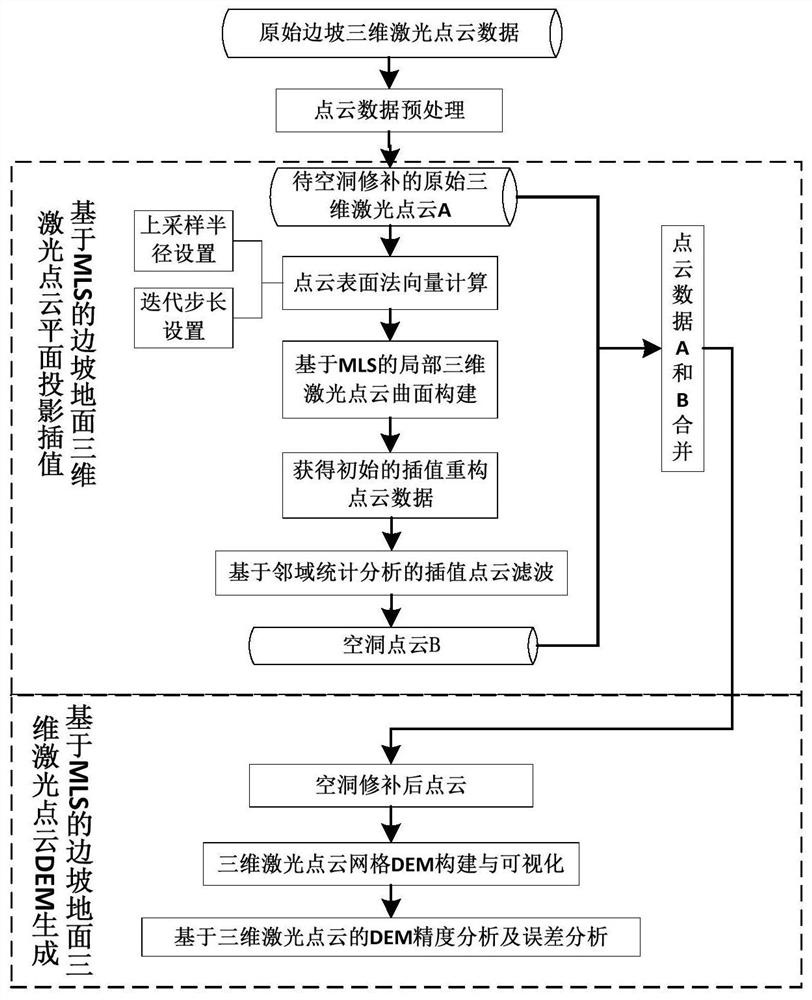
[0023] The following will be combined with the attachment to build a three -dimensional laser dot cloud data grid DEM built as an example of a slope three -dimensional laser point cloud data obtained by the ground three -dimensional laser scanner as an example to illustrate the specific implementation method of the present invention:

[0024] 1. Obtain the slope point cloud through the three -dimensional laser scanning system on the ground, and prepro processing it for it to obtain the original point cloud that is to be repaired by the empty hole.

[0025] Use the RIEGL VZ-1000 three-dimensional laser scanner to collect data to collect a slope, obtain the three-dimensional laser point cloud data of the slope, and set the scanning mode to Panorama_20 to obtain dense laser point cloud data. After the collection of foreign data, the internal industry uses the Riscan Pro software to operate the three -dimensional laser point cloud data obtained by the obtained three -dimensional laser...


PUM


Abstract

The invention discloses a method for generating a slope DEM based on a three-dimensional laser point cloud on the ground. The three-dimensional laser point cloud data reflecting the global characteristics of the slope surface was obtained by using the three-dimensional laser scanning system, and the three-dimensional laser point cloud of the slope ground was projected and interpolated based on the principle of moving least squares to obtain the interpolation and reconstruction of the three-dimensional point cloud of the slope. The 3D point cloud K is adjacent to the average distance, identify the hole repair point cloud from the interpolation and reconstructed 3D point cloud, and fuse the hole repair point cloud into the original 3D laser point cloud, so as to realize the hole adaptive repair of the 3D laser point cloud; Finally, the MLS principle is used to fit the projection plane, and the normal vector of the point cloud is calculated. The DEM triangulation model is constructed using the Delaunay criterion, and the half-edge data structure is used to organize and manage the triangular facets. The invention can use discrete point cloud data to construct a slope DEM, and provide abundant terrain information for digital disaster reduction, resource mining, safe production and the like.

Description

Technical field [0001] The invention involves the field of three -dimensional laser point cloud data processing, which specifically involves a high -efficiency method of DEM -based slope DEM on the ground three -dimensional laser point cloud. Background technique [0002] As a common geological disaster, landslides have brought huge threats to the ecological environment and people's life and property security. The dynamic monitoring and analysis of landslides has become a key issue for public institutions at home and abroad to support disaster response. The traditional slope deformation monitoring method is mainly a local point monitoring. There are shortcomings such as the global characteristics of deformed global features with less sampling points. Based on the monitoring method of three -dimensional laser scanning technology, you can obtain 3D laser dot cloud data reflecting the global characteristics of the slope surface, and use discretely dot cloud data to build a landslide...

Claims


Application Information

Patent Timeline
Patent Type & Authority Patents(China)
IPC IPC(8): G06T17/05G06T5/00G06T3/40G06V10/764G06F16/29
CPCG06T5/002G06T17/05G06T3/4023G06F16/29G06T2207/10028G06F18/24143
Inventor 王永志廖丽霞李辉王宝娟胡晓宇
Owner JIANGXI UNIV OF SCI & TECH
Why Eureka
Try Eureka