A path planning method, device, storage medium and electronic device

A planning and route technology, applied in the field of data processing, can solve the problems of laying ground sense coils, high cost of ground sense coils, and inability to represent the real situation of the road, so as to achieve the effect of accurate current routes and improved travel efficiency

Active Publication Date: 2022-08-02
BEIJING DIDI INFINITY TECH & DEV
View PDF16 Cites 0 Cited by
  • Summary
  • Abstract
  • Description
  • Claims
  • Application Information

AI Technical Summary

Problems solved by technology

[0003] In the traditional technology, when the navigation system plans the driving route for the user, one method is: collect the number of vehicles and driving speed of a certain road section through the laid ground induction coil, and then use the number of vehicles and driving speed to judge the traffic condition of the road section However, the cost of ground induction coils is high, and it is impossible to lay ground induction coils on all road sections. Therefore, there will be missed detections, which will cause the navigation system to be unable to accurately plan the most reasonable driving route.
Another kind of method is: utilize the Global Positioning System (Global Positioning System, GPS) data that floating vehicle collects to judge the traffic condition of road section, but because the quantity of floating vehicle is less, therefore, the GPS data collected is a part of the road on the road. A small number of samples cannot represent the real situation of the road, and it is impossible to accurately plan the most reasonable driving path

Method used


Image

  • A path planning method, device, storage medium and electronic device
  • A path planning method, device, storage medium and electronic device
  • A path planning method, device, storage medium and electronic device

Examples


Embodiment Construction

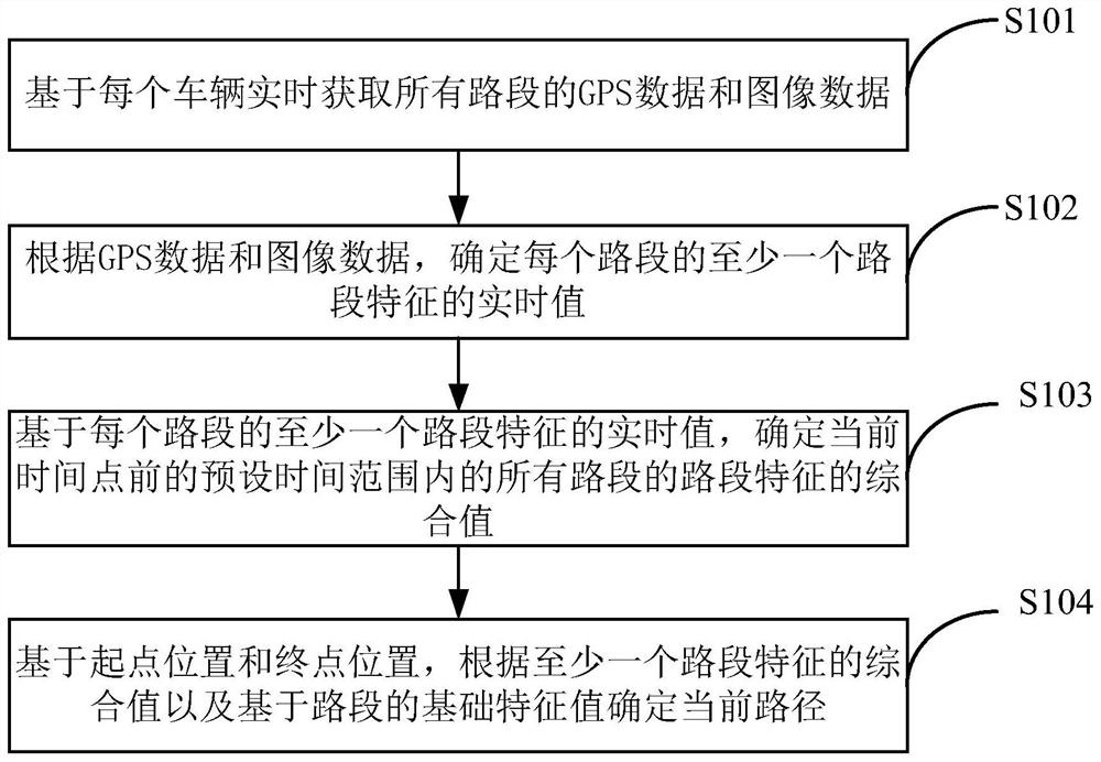
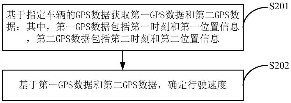
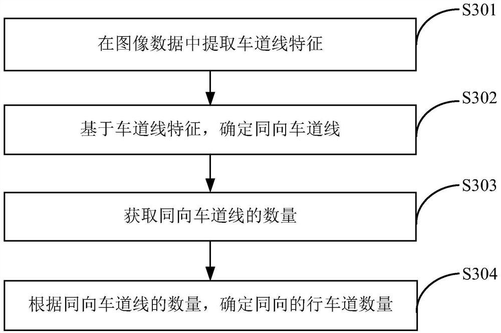
[0075] In order to make the objectives, technical solutions and advantages of the present disclosure clearer, the technical solutions of the present disclosure will be clearly and completely described below with reference to the accompanying drawings of the present disclosure. Obviously, the described embodiments are some, but not all, embodiments of the present disclosure. Based on the described embodiments of the present disclosure, all other embodiments obtained by those of ordinary skill in the art without creative efforts fall within the protection scope of the present disclosure.

[0076] Unless otherwise defined, technical or scientific terms used in this disclosure shall have the ordinary meaning as understood by one of ordinary skill in the art to which this disclosure belongs. As used in this disclosure, "first," "second," and similar terms do not denote any order, quantity, or importance, but are merely used to distinguish the various components. "Comprises" or "co...


PUM


Abstract

The present disclosure provides a path planning method, device, storage medium and electronic device. In the planning method, a vehicle is used to acquire GPS data and image data of a road segment in real time, and at least one road segment of each road segment is determined according to the GPS data and the image data. The real-time value of the feature; then, based on the real-time value of at least one feature of each road segment, determine the comprehensive value of the feature of all the segments within the preset time range before the current time point; After the location, based on the starting point position and the ending point position, the current path is determined according to the comprehensive value of the feature of at least one road segment and the basic feature value based on the road segment, and the current path is recommended to the user. Here, based on GPS data and image data, the road segment characteristics of the road segment can be obtained more comprehensively, thereby making the planned current route more accurate and improving the travel efficiency of the user.

Description

technical field [0001] The present disclosure relates to the technical field of data processing, and in particular, to a path planning method, apparatus, storage medium and electronic device. Background technique [0002] The navigation system on the vehicle not only allows users to know their exact location anytime and anywhere in the process of driving, but also can plan a reasonable driving path for users before driving, which is convenient for users to travel. [0003] In the traditional technology, when the navigation system plans the driving route for the user, one method is to collect the number of vehicles and the driving speed of a road section through the laid ground sensing coil, and then use the number of vehicles and driving speed to judge the traffic condition of the road section. However, the cost of ground sensing coils is high, and ground sensing coils cannot be laid on all road sections. Therefore, there will be missed detections, resulting in the inability...

Claims


Application Information

Patent Timeline
Patent Type & Authority Patents(China)
IPC IPC(8): G01C21/34
CPCG01C21/3492G01C21/3461
Inventor 刘梦瑶车正平史雪凤张新圣
Owner BEIJING DIDI INFINITY TECH & DEV
Why Eureka
Try Eureka