High-resolution remote sensing image newly-added building automatic recognition method

A remote sensing image, high-resolution technology, applied in character and pattern recognition, instrumentation, computing, etc., can solve problems such as low degree of automation, single feature, and high noise.

Active Publication Date: 2020-06-26
浙江明州测绘院
View PDF5 Cites 6 Cited by
  • Summary
  • Abstract
  • Description
  • Claims
  • Application Information

AI Technical Summary

Problems solved by technology

However, the features used in the existing methods are relatively single, and cannot fully express the characteristics of buildings. The integrity and accuracy of identifying buildings

Method used


Image

  • High-resolution remote sensing image newly-added building automatic recognition method
  • High-resolution remote sensing image newly-added building automatic recognition method
  • High-resolution remote sensing image newly-added building automatic recognition method

Examples


Embodiment Construction

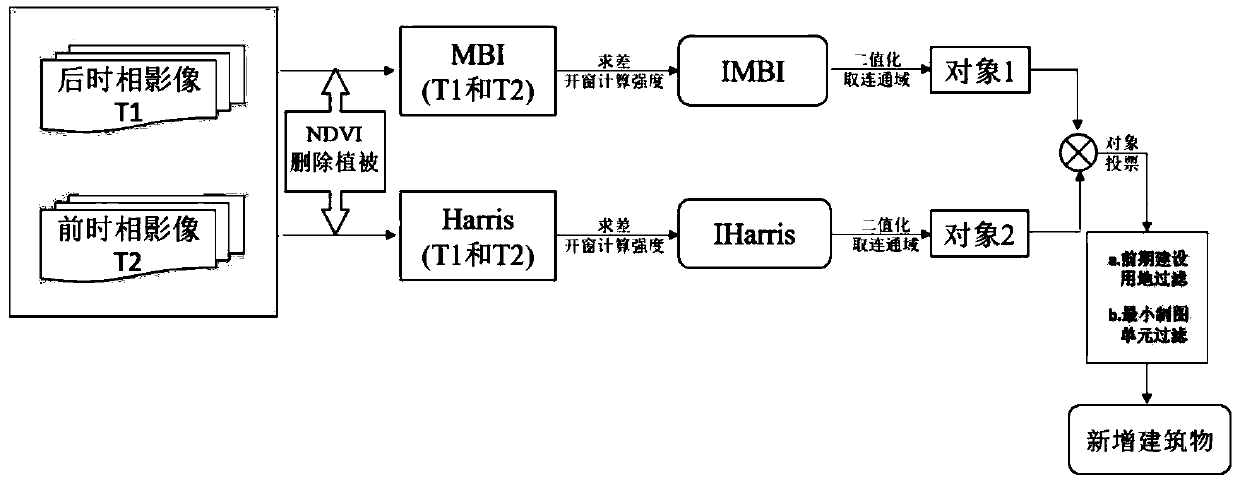
[0108] Step 1. Perform geometric fine correction and relative radiation correction on high-resolution images of different time phases;

[0109] Step 2. Obtain the characteristics of the two temporal images before and after: MBI, Harris, NDVI;

[0110]In step 2, multi-temporal building information is extracted directly through two building indices: Morphological Building Index (MBI) and Harris corner feature. Harris is calculated based on the brightness image (maximum value in the visible light band), and is a method for calculating corner features. Index, using a detection window, detects whether the average energy in the window changes when it moves slightly in all directions, it is a relatively stable feature extraction algorithm; MBI is also calculated from the brightness image, it is an automatic extraction of high-resolution The morphological index of the building on the image is based on the spectral and texture information of the building on the image to perform morphol...


PUM


Abstract

The invention relates to an automatic recognition method for a newly-added building in a high-resolution remote sensing image. The automatic recognition method mainly comprises the following steps: 1)carrying out geometric fine correction and relative radiation correction on high-resolution images of different time phases; 2) calculating and obtaining MBI (morphological building index), Harris and NDVI (normalized difference vegetation index) characteristics of the front and rear time phase images; 3) removing a vegetation area in the building features; 4) calculating a feature hotspot map; 5) taking a threshold value of the feature hotspot map; according to the method, the newly-added building can be automatically extracted based on the remote sensing image, and an effective technical means is provided for land monitoring and management. The method has the advantages that the newly-added building can be automatically extracted based on the remote sensing image;

Description

technical field [0001] The invention belongs to the technical field of remote sensing image processing, and mainly relates to a new building change detection method in land use change detection, in particular to an automatic recognition method for new buildings in high-resolution remote sensing images based on MBI (morphological building index) and Harris . Background technique [0002] Since the expansion of construction land needs to occupy other non-construction areas (such as: cultivated land, forest land, bare land, etc.), land use changes frequently, and the original land survey method in my country, which mainly relies on a large amount of manpower to visually interpret images, can no longer meet the new situation. Under the requirements of land management. The rapid development of remote sensing technology and computer technology has become an important means to monitor land use and find illegal buildings. With the deepening of land and resources management, it is r...

Claims


Application Information

Patent Timeline
IPC IPC(8): G06K9/00G06K9/46G06K9/62
CPCG06V20/176G06V20/41G06V10/40G06F18/2415
Inventor 黄昕常晓宇李家艺曹银霞
Owner 浙江明州测绘院
Why Eureka
Try Eureka