Method for measuring and calculating overground biomass of plant

A biomass and vegetation technology, which is applied in the field of plant biomass measurement and calculation, can solve the problems of low estimation accuracy, time-consuming and laborious, and large spatial variability, and achieve high data reliability, wide application range, and high measurement accuracy. Effect

Inactive Publication Date: 2020-07-14
PEKING UNIV SHENZHEN GRADUATE SCHOOL
View PDF5 Cites 2 Cited by
  • Summary
  • Abstract
  • Description
  • Claims
  • Application Information

AI Technical Summary

Problems solved by technology

Among them, although the ground measurement method has high precision and reliable results, it is time-consuming and laborious, suitable for small scale, and destructive to plants
The remote sensing estimation method mainly relies on satellite remote sensing images and ground measured biomass data, builds biomass models through regression statistics or machine learning algorithms, and then realizes a wide range of biomass estimation and dynamic analysis, but its estimation accuracy is low, and Large spatial variability
[0003] In recent years, the rapid development of UAV remote sensing has produced a method to measure and calculate aboveground biomass using UAV re...

Method used


Image

  • Method for measuring and calculating overground biomass of plant

Examples


Embodiment Construction

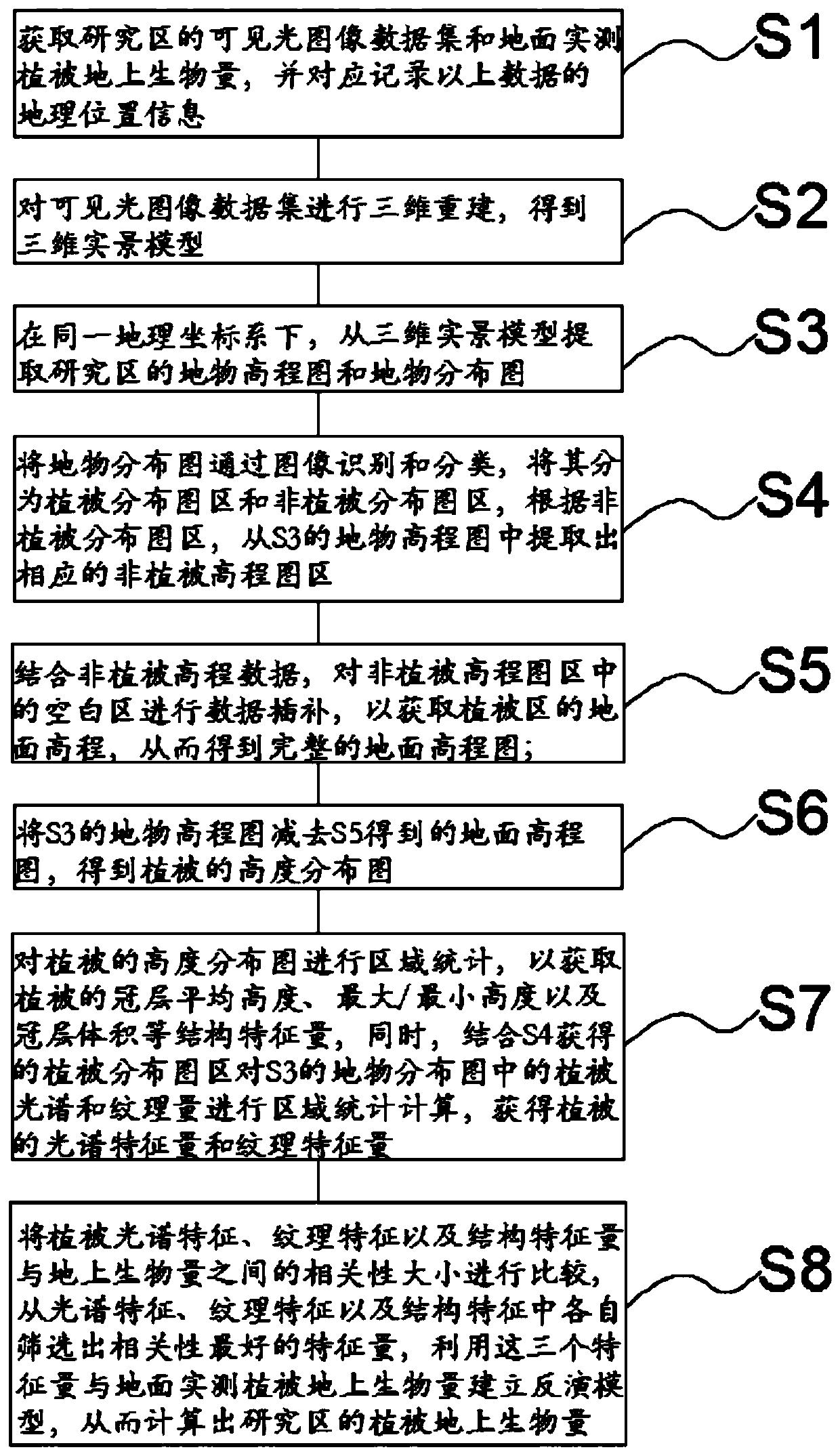
[0025] See figure 1 , the present invention also provides a kind of measuring method of aboveground biomass of plants, comprising the following steps:

[0026] S1: Obtain the visible light image data set and the aboveground biomass of vegetation measured on the ground in the study area, and record the geographic location information of the above data;

[0027] Further, in S1, the visible light image data set is obtained by a visible light sensor, and the visible light sensor is a visible light sensor of a drone or a visible light sensor of a mobile phone.

[0028] S2: Perform 3D reconstruction on the visible light image dataset to obtain a 3D real scene model;

[0029] Specifically, the process of building a three-dimensional real scene model from the visible light image data set is realized by photogrammetry.

[0030] S3: Under the same geographic coordinate system, extract the elevation map and distribution map of the ground features in the study area from the 3D real scen...


PUM


Abstract

The invention relates to a method for measuring and calculating overground biomass of a plant. The method comprises the following steps: S1, acquiring visible light image data and ground measured vegetation aboveground biomass; S2, establishing a three-dimensional realistic picture; S3, extracting a ground object elevation map and a ground object distribution map from the three-dimensional realistic picture, and obtaining geographic position information of the two maps to be consistent; S4, dividing the ground object distribution map into vegetation and non-vegetation distribution map areas, and calculating spectral indexes and texture characteristic quantities of visible light of the vegetation distribution map areas; extracting a corresponding non-vegetation elevation map area from the ground object elevation map; S5, performing data interpolation on a blank area in the non-vegetation elevation map area to obtain a ground elevation map; S6, subtracting the ground object elevation maps in S3 and S5 to obtain vegetation height data distribution; S7, acquiring canopy height data of vegetation, and performing regional statistics on spectral indexes, texture characteristic quantities,canopy heights and the like of visible light to obtain related characteristic quantities; and S8, screening the characteristic quantity, and calculating the vegetation aboveground biomass by combining with the actually measured vegetation aboveground biomass on the ground.

Description

technical field [0001] The invention relates to a method for measuring and calculating the aboveground biomass of plants. Background technique [0002] Terrestrial plant biomass is a very important indicator for the study of ecosystem energy changes and carbon storage changes, so it is very meaningful to measure it accurately. Plant biomass is divided into above-ground biomass and underground biomass. Above-ground biomass refers to the dry weight of plants above the surface per unit area. At present, the main methods for its calculation are ground measurement and remote sensing estimation. Among them, although the ground measurement method has high precision and reliable results, it is time-consuming and laborious, suitable for small scale, and destructive to plants. The remote sensing estimation method mainly relies on satellite remote sensing images and ground measured biomass data, builds biomass models through regression statistics or machine learning algorithms, and th...

Claims


Application Information

Patent Timeline
IPC IPC(8): G06K9/00G06K9/62G06T17/05
CPCG06T17/05G06V20/188G06F18/2113G06F18/24
Inventor 邱国玉毛鹏郝梦宇秦龙君赵文利熊博文罗婕纯一丁俊杰
Owner PEKING UNIV SHENZHEN GRADUATE SCHOOL
Why Eureka
Try Eureka