Method and system for simulating point location data by utilizing road network data

A technology of road network data and location data, applied in the field of data simulation, can solve the problems of matching the actual geographical environment, incomplete points, waste of resources and manual use, etc., and achieve the effect of improving the accuracy of simulation

Pending Publication Date: 2020-07-17
GENEW TECH
View PDF1 Cites 2 Cited by
  • Summary
  • Abstract
  • Description
  • Claims
  • Application Information

AI Technical Summary

Problems solved by technology

[0005] In view of the deficiencies in the prior art, the purpose of the present invention is to provide a method for simulating point data using road network data, aiming to solve the problem that the simulated point does not completely match the actual geographical environment when performing point simulation in the prior art. It is easy to cause waste of resources and manual use

Method used


Image

  • Method and system for simulating point location data by utilizing road network data
  • Method and system for simulating point location data by utilizing road network data
  • Method and system for simulating point location data by utilizing road network data

Examples


Embodiment Construction

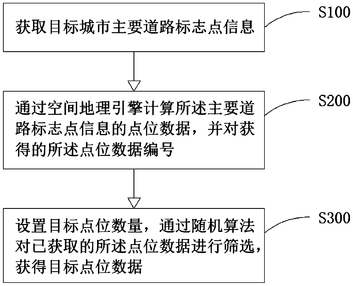
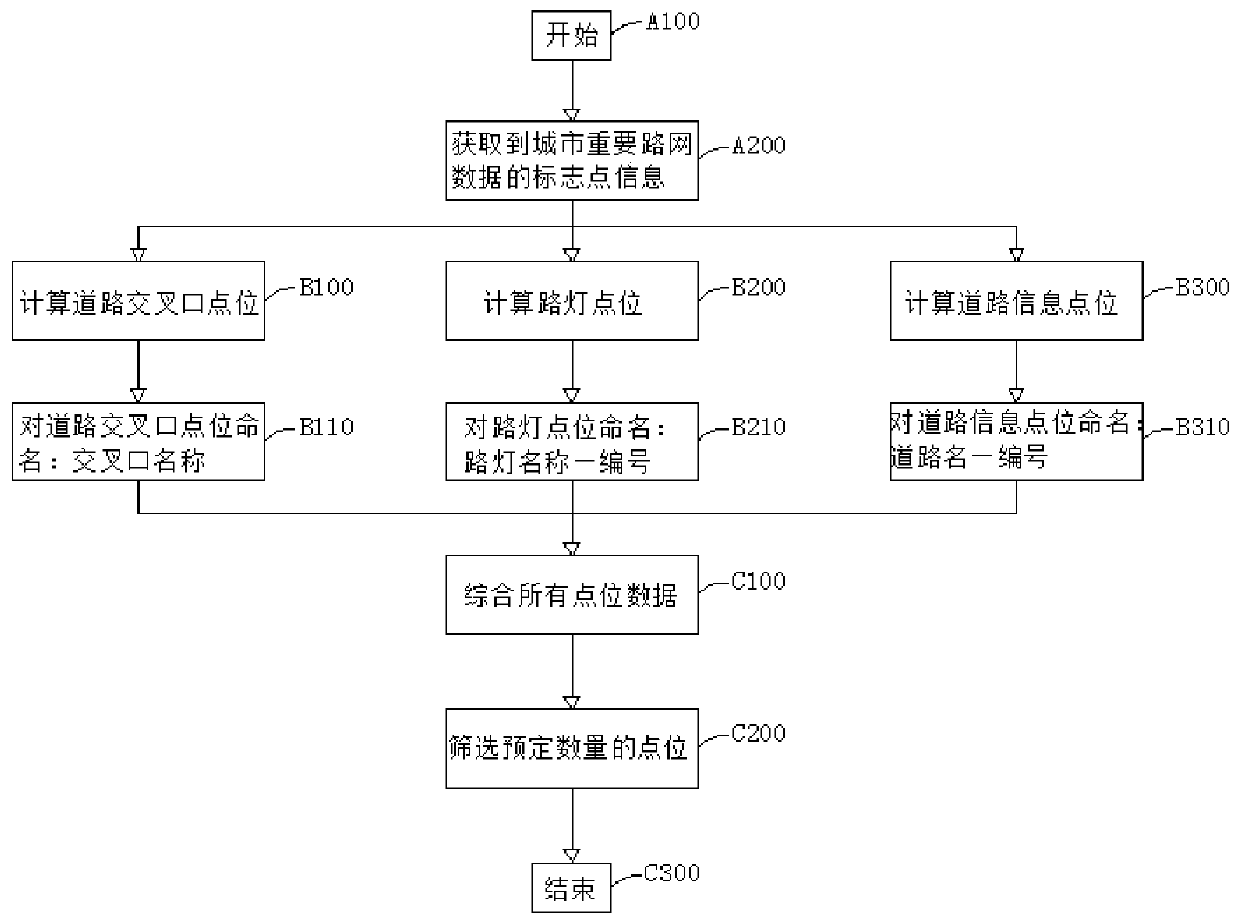
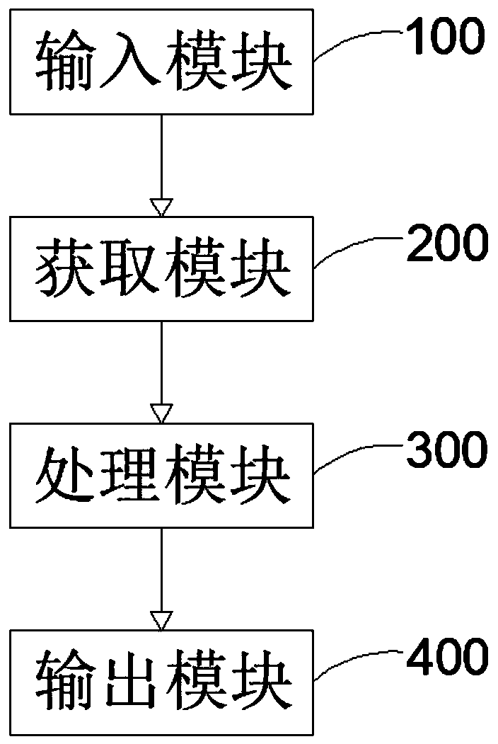
[0028] In order to make the object, technical solution and advantages of the present invention more clear and definite, the present invention will be further described in detail below with reference to the accompanying drawings and examples. It should be understood that the specific embodiments described here are only used to explain the present invention, not to limit the present invention.

[0029] It should be noted that if there are directional indications (such as up, down, left, right, front, back...) in the embodiment of the present invention, the directional indications are only used to explain the position in a certain posture (as shown in the accompanying drawing). The relative positional relationship and movement conditions among the various components shown in ) below, if the specific posture changes, the directional indication will also change accordingly.

[0030] In addition, if there are descriptions involving "first", "second", etc. in the embodiments of the p...


PUM


Abstract

The invention provides a method and a system for simulating point location data by utilizing road network data. The method comprises the following steps: acquiring main road sign point information ofa target city; calculating point location data of the main road sign points through a spatial geography engine, and numbering the obtained point location data; and setting the number of target point locations, and screening the obtained point location data through a random algorithm to obtain target point location data. The method comprises the following steps: acquiring mark points in an urban road network; converting all the mark points into point position data; randomly screening the number of actually required point locations in the obtained point location data; the geographic positions ofthe simulation point positions obtained through the method are all located in a reasonable construction range, the method conforms to a real application scene, the situation that invalid point positions are generated is avoided, it is ensured that simulated data are closer to real application, and the development efficiency and the interface effect are improved.

Description

technical field [0001] The invention relates to the field of data simulation, in particular to a method and system for simulating point data using road network data. Background technique [0002] In emergency construction based on GLS maps such as urban infrastructure layout and urban dynamic monitoring, it is often necessary to simulate a large amount of urban data as the basis for setting point data, and use the simulated point data as the basis for actual facility construction. [0003] The existing point data simulation method is to draw an area similar to the city outline, and use a random algorithm to put the point into the outline area, so as to obtain evenly distributed point data. For example, when laying urban cameras, First draw the outline of the area to be laid, and then use a random algorithm to simulate the point. The position of the simulated point is the position where the camera needs to be set up. However, in actual operation, there are often situations wh...

Claims


Application Information

Patent Timeline
Patent Type & Authority Applications(China)
IPC IPC(8): G06F16/29
CPCG06F16/29
Inventor 陈志芬卫宣安姜坤吴闽华
Owner GENEW TECH
Why Eureka
Try Eureka