
Real-time trajectory prediction method for unmanned aerial vehicle

A trajectory prediction, UAV technology, applied in neural learning methods, biological neural network models, instruments, etc., can solve the problems of slow trajectory prediction, difficult identification of UAV flight status, and low trajectory prediction accuracy. Prediction accuracy, avoidance of dynamic modeling, and the effect of improving management systems

Active Publication Date: 2020-07-28
NANJING UNIV OF AERONAUTICS & ASTRONAUTICS
View PDF5 Cites 5 Cited by
  • Summary
  • Abstract
  • Description
  • Claims
  • Application Information

AI Technical Summary

Problems solved by technology

[0005] In view of the deficiencies in the prior art above, the purpose of the present invention is to provide a real-time trajectory prediction method for UAVs to solve the problems in the prior art that the flight status of the UAV is difficult to identify, the trajectory prediction accuracy is low, and the trajectory prediction speed is slow. The method of the present invention can capture the flight state of the drone, make full use of the historical track point information, avoid the conflict and collision of the drone, and ensure that many drones fly safely and orderly in the low-altitude airspace

Method used


Image

  • Real-time trajectory prediction method for unmanned aerial vehicle
  • Real-time trajectory prediction method for unmanned aerial vehicle
  • Real-time trajectory prediction method for unmanned aerial vehicle

Examples


Embodiment Construction

[0063] In order to facilitate the understanding of those skilled in the art, the present invention will be further described below in conjunction with the embodiments and accompanying drawings, and the contents mentioned in the embodiments are not intended to limit the present invention.

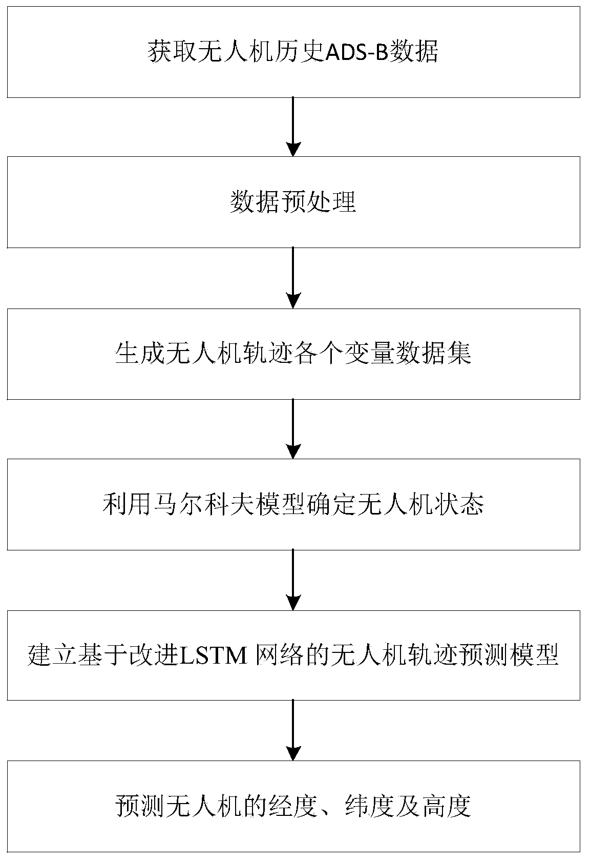
[0064] refer to figure 1 , image 3 Shown, a kind of unmanned aerial vehicle real-time trajectory prediction method of the present invention, the steps are as follows:

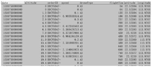
[0065] (1) Obtain data: collect historical ADS-B data of drones, see figure 2 As shown, the data information of drone timestamp, drone ID, latitude, longitude, altitude, horizontal speed, and flight time are obtained.

[0066] (2) Data preprocessing: sort the above-mentioned acquired data information by flight time, convert latitude and longitude into Cartesian coordinates; and delete data with non-fixed time intervals and non-obvious location information in the acquired data.

[0067] (3) Generate variable data sets of ...


PUM


Abstract

The invention discloses a real-time trajectory prediction method for an unmanned aerial vehicle. The method comprises the following steps: (1) acquiring data; (2) carrying out data preprocessing; (3)generating each variable data set of the unmanned aerial vehicle trajectory; (4) determining the state of the unmanned aerial vehicle by using a Markov model; (5) adding a BN layer according to the state of the unmanned aerial vehicle, and establishing an unmanned aerial vehicle trajectory prediction model based on an LSTM network; and (6) predicting the longitude, latitude and height of the unmanned aerial vehicle. According to the method, the flight state of the unmanned aerial vehicle can be captured, historical track point information is fully utilized, conflict and collision of the unmanned aerial vehicle are avoided, and safe and orderly flight of numerous unmanned aerial vehicles in a low-altitude airspace is guaranteed.

Description

technical field [0001] The invention belongs to the technical field of air traffic flow management, and in particular relates to a real-time track prediction method of an unmanned aerial vehicle. Background technique [0002] Unmanned aircraft, referred to as "unmanned aerial vehicle", or "UAV" in English, is an unmanned aircraft that is controlled by radio remote control equipment and its own program control device, or is completely or intermittently operated autonomously by an on-board computer. [0003] UAVs have simple structure, strong maneuverability, and changeable flight states. Therefore, their flight states and trajectories are difficult to predict. With the increasing demand and number of UAVs, in order to avoid conflicts and collisions between UAVs and ensure the safe and orderly flight of many UAVs in low-altitude airspace, further research on UAV trajectory prediction methods is required. , so as to provide decision support for UAV conflict detection, abnormal...

Claims


Application Information

Patent Timeline
Patent Type & Authority Applications(China)
IPC IPC(8): G06N3/04G06N3/08G06N7/00
CPCG06N3/08G06N7/01G06N3/044G06N3/045Y02T10/40
Inventor 羊钊陆佳欢唐荣刘皞张洪海王兵张颖
Owner NANJING UNIV OF AERONAUTICS & ASTRONAUTICS
Learn More