Slope leveling method, device and equipment based on GNSS single-antenna satellite

A single-antenna, satellite technology, applied in the field of land survey and improvement, can solve problems such as too much data, multiple antenna satellites, etc.

Active Publication Date: 2020-08-07
SHANGHAI ALLYNAV TECH CO LTD
View PDF7 Cites 0 Cited by
  • Summary
  • Abstract
  • Description
  • Claims
  • Application Information

AI Technical Summary

Problems solved by technology

[0005] The purpose of the present invention is to provide a method, device, equipment and computer-readable storage medium for slope adjustment based on GNSS single-antenna satellites, so as to solve the problem of too much data and the need for multiple satellites to determine the points that the slope equation needs to collect in the prior art. Antenna Satellite Problems

Method used


Image

  • Slope leveling method, device and equipment based on GNSS single-antenna satellite
  • Slope leveling method, device and equipment based on GNSS single-antenna satellite
  • Slope leveling method, device and equipment based on GNSS single-antenna satellite

Examples


specific Embodiment approach

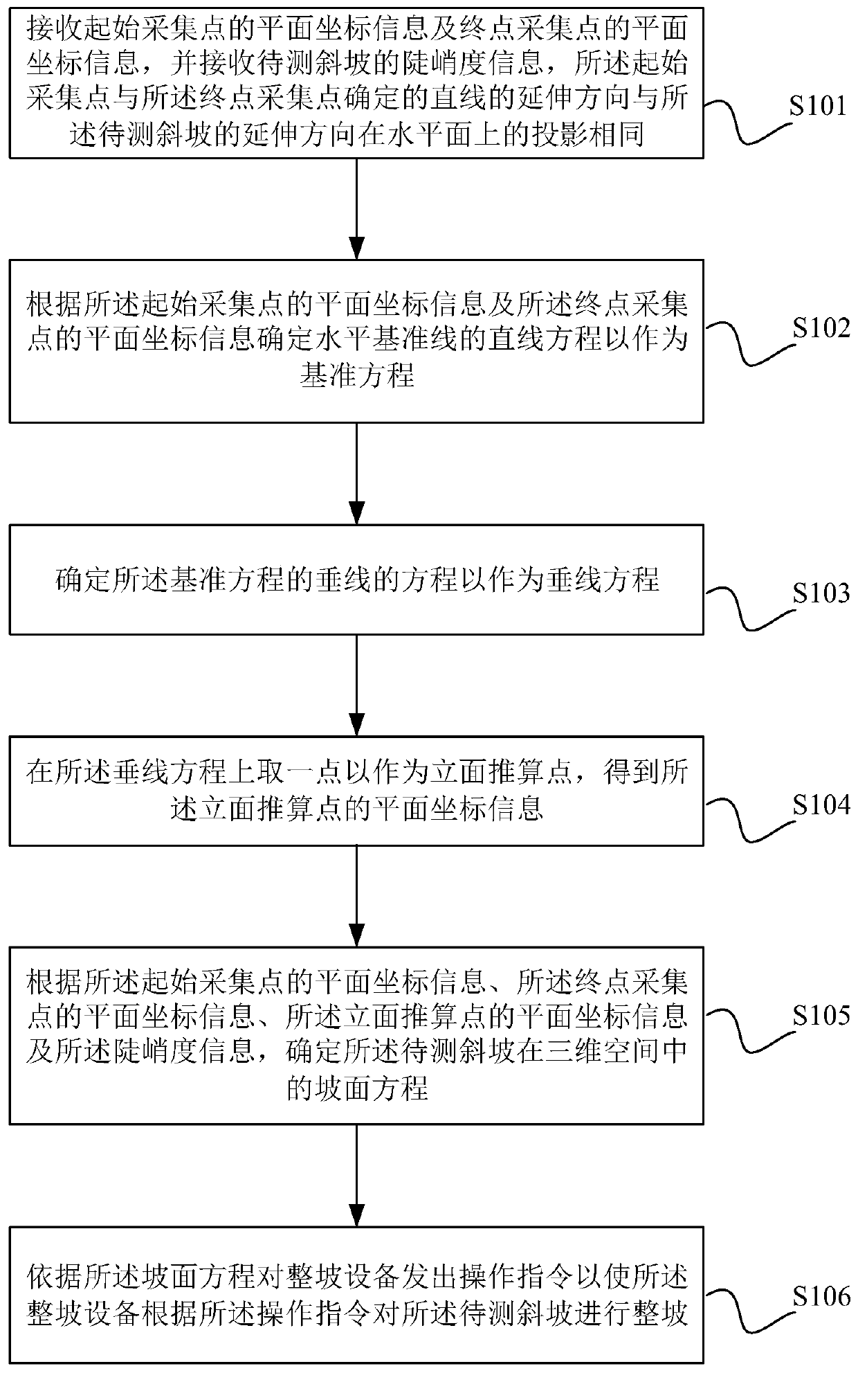
[0047] The core of the present invention is to provide a kind of whole slope method based on GNSS single-antenna satellite, and the schematic flow chart of its a kind of specific implementation is as figure 1 As shown, it is called the first specific implementation mode, including:

[0048] Step S101: receiving the plane coordinate information of the start collection point and the plane coordinate information of the end point collection point, and receiving the steepness information of the slope to be measured, the extension direction of the straight line determined by the start collection point and the end point collection point is consistent with The projections of the extending direction of the slope to be measured on the horizontal plane are the same.


PUM


Abstract

The invention discloses a slope shaping method based on a GNSS single-antenna satellite. The method comprises the steps of: receiving plane coordinate information of a starting collection point and plane coordinate information of an end point collection point, receiving steepness information of a slope to be measured, wherein the extension direction of a straight line determined by the starting collection point and the end point collection point is the same as the projection of the extension direction of the slope to be measured on the horizontal plane; determining a reference equation; determining a vertical line equation; obtaining plane coordinate information of a facade reckoning point; and determining a slope equation according to the plane coordinate information of an initial acquisition point, the plane coordinate information of an end point acquisition point, the plane coordinate information of the facade reckoning point and the steepness information, and carrying out slope preparation. According to the invention, the process is simplified, and the requirement of measurement on a GNSS system is reduced. The invention further provides a slope shaping method, device and equipment based on the GNSS single-antenna satellite and a computer readable storage medium, wherein the slope shaping method, device and equipment have the advantages.

Description

technical field [0001] The invention relates to the field of land surveying and improvement, in particular to a method, device, equipment and computer-readable storage medium for slope adjustment based on GNSS single-antenna satellites. Background technique [0002] With the development of society and the expansion of cities, people's demand for land transformation is becoming stronger and stronger. Among them, land leveling of undulating land due to construction needs or agricultural needs is one of the main demands, and slope leveling is one of the flat lands. The common type uses slope leveling, which will create a custom slope, which is conducive to irrigation and water-saving measures. Therefore, the smoothness of slope leveling is particularly important. In conventional slope leveling, manual observation, leveling, and work based on experience are low in efficiency and have certain defects in leveling. Therefore, the current common slope leveling method based on GNSS. ...

Claims


Application Information

Patent Timeline
Patent Type & Authority Applications(China)
IPC IPC(8): G01C9/00G01C5/00G01B7/34G01S19/38
CPCG01B7/34G01C5/00G01C9/00G01S19/38
Inventor 董方圆徐纪洋马飞秦振丰司剑黄侠
Owner SHANGHAI ALLYNAV TECH CO LTD
Why Eureka
Try Eureka