High-precision map road information rapid generation system and method based on space-time trajectory reconstruction

A technology of space-time trajectory and road information, which is applied in the traffic control system of road vehicles, traffic control system, road network navigator, etc., can solve the problems of not being able to reflect the special situation of the road surface in time, and the process of drawing diversion high-precision maps is complicated.

Active Publication Date: 2020-08-25
河北德冠隆电子科技有限公司
View PDF8 Cites 21 Cited by
  • Summary
  • Abstract
  • Description
  • Claims
  • Application Information

AI Technical Summary

Problems solved by technology

[0004] For this reason, the present invention provides a system and method for quickly generating road information of high-precision maps based on spatio-temporal trajectory recon

Method used


Image

  • High-precision map road information rapid generation system and method based on space-time trajectory reconstruction
  • High-precision map road information rapid generation system and method based on space-time trajectory reconstruction
  • High-precision map road information rapid generation system and method based on space-time trajectory reconstruction

Examples


Embodiment 1

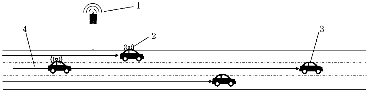
[0051]This embodiment discloses a high-precision map road information rapid generation system based on spatio-temporal trajectory reconstruction. The system includes: a trajectory reconstruction module, a lane determination module, a lane separation module, a lane boundary line drawing module, and a multi-data synthesis and fusion module. The trajectory reconstruction module uses the roadside sensing unit 1 to collect dynamic information, road condition information, feature information, traffic status information, climate information, and various abnormal event information of all types of vehicles driving on the road, and uses the vehicle-mounted unit 2 to dynamically obtain them in real time. Vehicle location information, road condition information around itself and location information relative to the vehicle, environmental information, marking information and location information relative to the vehicle, event information that endangers the safe driving of the vehicle, road s...

Embodiment 2

[0059] This embodiment discloses a method for quickly generating road information based on the reconstruction of high-precision maps based on spatio-temporal trajectories. The method is as follows:

[0060] S1. Perform spatiotemporal trajectory reconstruction, use the vehicle travel path and road surface state information collected by the roadside sensing unit 1 and the vehicle unit 2 to perform reverse spatiotemporal trajectory reconstruction, and draw the vehicle travel trajectory;

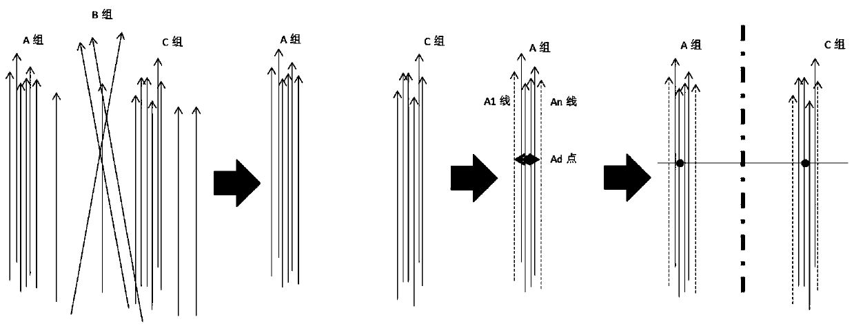
[0061] S2. Determine the lane, eliminate the interference driving track, and determine the range of a single lane;

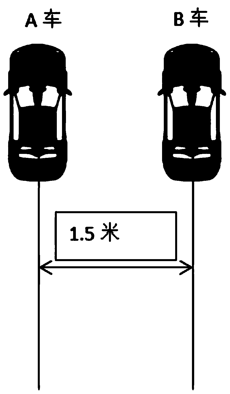
[0062] S3, draw the lane separation line 5, determine the middle point of the track in the single lane, connect the middle points of the track on the agreed horizontal line of the adjacent single lanes, get the position of the middle point of the connection line as the lane separation point, and use the lane separation point Draw a lane separation line 5 for a line whose starting ...


PUM


Abstract

The invention discloses a high-precision map road information rapid generation system and method based on space-time trajectory reconstruction. The system comprises a track reconstruction module, a lane determination module, a lane separation module, a lane boundary line drawing module and a multi-data synthesis fusion module, wherein the track reconstruction module performs reverse space-time reconstruction of a vehicle driving track by utilizing the vehicle track information acquired by a roadside sensing unit and a vehicle-mounted unit, the lane determination module determines a lane according to a distance between vehicle driving tracks, the lane separation module draws a lane separation line at a midpoint of connecting lines of middle points of the adjacent single lane tracks, the lane boundary line drawing module draws a lane boundary line according to the vehicle driving track direction and the driving speed by taking the lane separation line as the reference and combining the road standard width and various line widths, and the multi-data synthesis fusion module fuses the collected roadside sign information with a map. The system is advantaged in that problems that an existing diversion high-precision map drawing process is complex, and special conditions of a road surface cannot be reflected in time are solved.

Description

technical field [0001] Embodiments of the present invention relate to space-time trajectory reconstruction, road side measurement, road survey, 3D model generation, map data generation, high-precision map drawing, automatic navigation, unmanned driving, automatic driving, automatic control, data transmission, road reconstruction, etc. A variety of fields, specifically related to a system and method for quickly generating road information based on spatio-temporal trajectory reconstruction of high-precision maps. Background technique [0002] At present, with the rapid development of autonomous driving technology, the importance of high-precision maps has become increasingly prominent, and has become an indispensable part of realizing unmanned driving and intelligent transportation. The accuracy of existing navigation maps is generally not high, and the entire road is used as an object to provide road information data or issue navigation instructions. This kind of navigation m...

Claims


Application Information

Patent Timeline
IPC IPC(8): G01C21/36G01C21/32G08G1/01
CPCG01C21/3667G01C21/32G08G1/0104
Inventor 冯保国耿驰远付增辉郝永坡
Owner 河北德冠隆电子科技有限公司
Why Eureka
Try Eureka