Remote sensing data elevation resolving method based on object space matching elevation deviation iterative correction

A technology of elevation data and remote sensing data, which is applied in complex mathematical operations, height/horizontal measurement, instruments, etc., can solve problems such as destroying image object information, high computational complexity, and limitation of input image imaging relationships, etc., to ensure accuracy and uniqueness, high computational efficiency and precision, and easy human visual interpretation

Active Publication Date: 2020-09-01
AEROSPACE INFORMATION RES INST CAS
View PDF9 Cites 1 Cited by
  • Summary
  • Abstract
  • Description
  • Claims
  • Application Information

AI Technical Summary

Problems solved by technology

[0008] (1) The matching method based on epipolar constraints has strict restrictions on the relationship between input images and imaging, and cannot be applied to obtain high-resolution remote sensing images from widely existing different viewing angles;
[0009] (2) The matching method based on epipolar constraints needs to project the image to be matched into the reference image coordinate system according to the epipolar relationship. The process of projection resampling will destroy the original object object information contained in the image, which is not conducive to obtaining real dense matching result;
[0010] (3) The object-space geometry-constrained multi-image correlation matching method based on elevation search needs to perform traversal search within a certain height range for each point to be matched, which has high computational complexity, and the accuracy of elevation calculation is related to the search step distance;
[0011] (4) Existing methods cannot design the processing process according to the target accuracy of the generated elevation data

Method used


Image

  • Remote sensing data elevation resolving method based on object space matching elevation deviation iterative correction
  • Remote sensing data elevation resolving method based on object space matching elevation deviation iterative correction
  • Remote sensing data elevation resolving method based on object space matching elevation deviation iterative correction

Examples


Embodiment Construction

[0050] In order to make the object, technical solution and advantages of the present invention clearer, the present invention will be further described in detail below in conjunction with specific embodiments and with reference to the accompanying drawings.

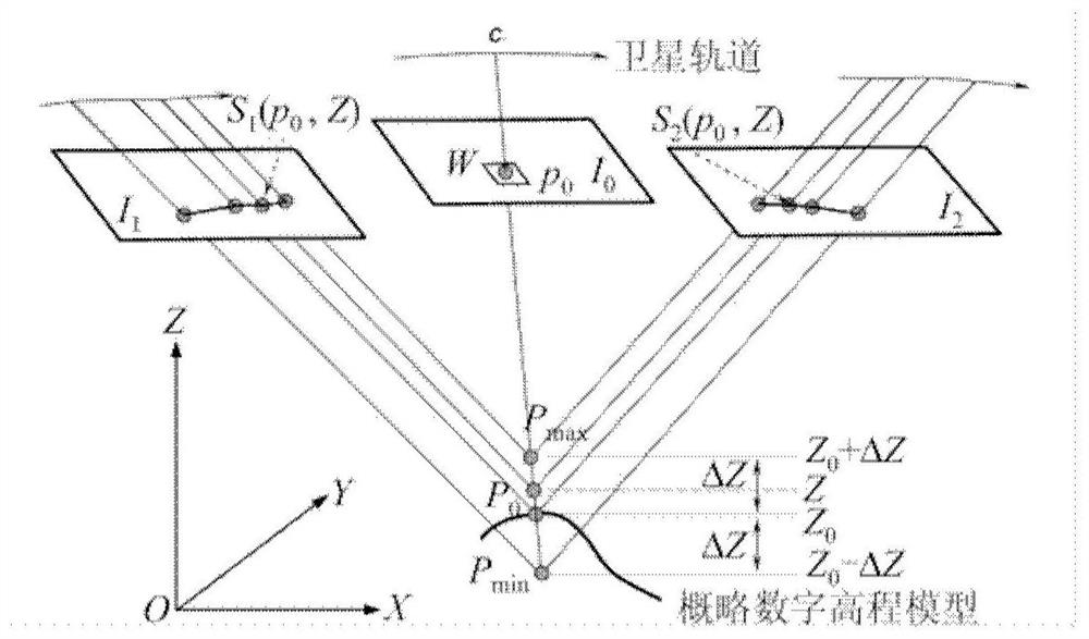
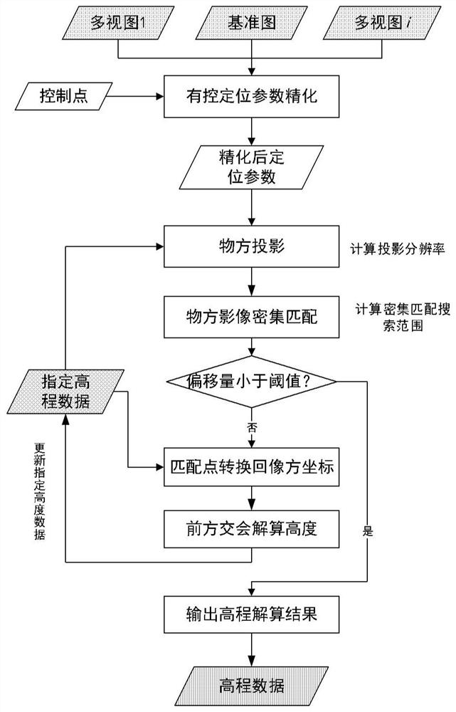
[0051]Aiming at the demand for fast and high-precision calculation of the elevation of the target area from remote sensing images, the present invention proposes a method for calculating the elevation of remote sensing data based on iterative correction of the height deviation of object space matching. The method has the following characteristics: 1) does not limit the multi-view data to be processed 2) Firstly, object-space projection is performed based on the specified elevation data (public elevation data or specified average elevation), and then matching is performed in the object-space coordinate system. The deviation obtained by matching is determined by the specified data and the real The deviation determination of ...


PUM


Abstract

A remote sensing data elevation resolving method based on object space matching elevation deviation iterative correction comprises the following steps of refining positioning information of a multi-view image based on a control point to acquire refined positioning information; projecting the multi-view image to an object space coordinate system based on the specified initial elevation data, and calculating the resolution adopted by projection; performing dense matching processing on the projected image pair, and calculating a search range parameter of dense matching according to the specifiedelevation data precision and the positioning parameter information; resolving an image space coordinate corresponding to the object space coordinate, and resolving through a forward intersection method to obtain a target height; taking the elevation data obtained by calculation as optimized specified elevation data, repeating the above steps, further optimizing the precision of the specified initial elevation data until the object space dense matching result is less than a certain threshold, and ending iteration to obtain optimized high-precision elevation data. The search range is limited andthe dense matching efficiency is improved while the calculation height precision is ensured, and epipolar constraint conditions are not needed.

Description

technical field [0001] The invention relates to the technical field of remote sensing data processing, and in particular designs a remote sensing data elevation calculation method based on iterative correction of object-side matching elevation deviation. Background technique [0002] Regional elevation data is an important basic data for remote sensing applications. It has important application value in three-dimensional spatial data processing and terrain analysis. It is widely used in orthophoto correction, surveying and mapping, soil erosion, road survey and design, land use management, landslides, etc. Monitoring and disaster control, hydrological model analysis, landform changes, etc. Compared with the relative generation of elevation data from aerial photography, spaceborne remote sensing data can obtain elevation data with a large coverage in a short period of time. To generate elevation data from optical satellite images, it is necessary to obtain dense matching res...

Claims


Application Information

Patent Timeline
IPC IPC(8): G06F17/10G01C5/00
CPCG06F17/10G01C5/00
Inventor 王峰胡玉新尤红建刘方坚向俞明
Owner AEROSPACE INFORMATION RES INST CAS
Why Eureka
Try Eureka