
GIS application based on Bezier curve algorithm

A Bezier curve and algorithm technology, which is applied in the GIS application field based on Bezier curve algorithm, can solve the problems of manual manufacturing and blunt generation effect, and achieve the effect of heavy workload.

Pending Publication Date: 2020-10-13
中电万维信息技术有限责任公司
View PDF0 Cites 8 Cited by
  • Summary
  • Abstract
  • Description
  • Claims
  • Application Information

AI Technical Summary

Problems solved by technology

[0002] The GIS geographic information platform can analyze and process spatial information. GIS technology integrates the visual effects of maps and geographic analysis functions. In the process of GIS information visualization, there is a great demand for simulated curve tracks or migration maps. However, traditional The data simulation process needs to manually create a large amount of discrete data with fixed latitude and longitude coordinate points, and the generation effect is relatively blunt

Method used


Image

  • GIS application based on Bezier curve algorithm
  • GIS application based on Bezier curve algorithm
  • GIS application based on Bezier curve algorithm

Examples


Embodiment Construction

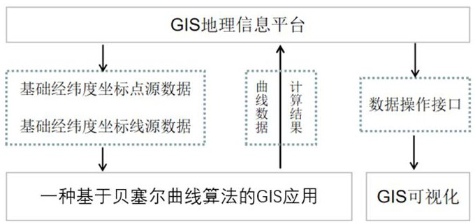
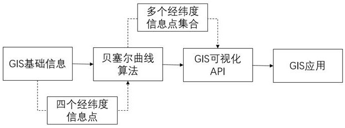
[0027] In conjunction with the above illustrations, the detailed operation steps and principles of the present invention are further described.

[0028] A kind of GIS application based on Bezier curve algorithm is characterized in that comprising the steps:

[0029] Select GIS geographic information, set the start point, end point, and two separate intermediate points, calculate the demand for vector lines between the four points through the Bezier curve algorithm, and calculate multiple discrete discrete points between the four known control points Coordinate points, connect the point set results generated by the calculation through the GIS method, and generate a curved line with a certain radian; the specific formula is as follows:

[0030]

[0031] Among them: B(t) is the coordinates of the point at time t; P0 is the starting point, P1 and P2 are the control points, and P3 is the end point.

[0032] The Bezier curve algorithm creates and edits graphics through a start p...


PUM


Abstract

The invention relates to a GIS application based on a Bezier curve algorithm, which is based on a GIS geographic information platform and meets the requirement of calculating vector lines among four known specific longitude and latitude coordinate points through the Bezier curve algorithm. In order to achieve radian lines, a large number of dense point sets with longitude and latitude fall must besimulated in traditional GIS application. The workload is large, large errors exist and the connection effect is relatively stiff. Through the three-order Bezier curve algorithm, a plurality of discrete coordinate points meeting conditions among four known control points are calculated, point set results generated by calculation are connected by the GIS method to generate a curved line with a certain radian, and the effects of population migration, solid waste transfer and the like are simulated. The requirement for realizing radian lines in the GIS information visualization process is more intelligent and convenient, and the goal of four-point curve simulation is achieved.

Description

technical field [0001] The invention relates to the field of digital image signal processing, in particular to a GIS application based on a Bezier curve algorithm. Background technique [0002] The GIS geographic information platform can analyze and process spatial information. GIS technology integrates the visual effects of maps and geographic analysis functions. In the process of GIS information visualization, there is a great demand for simulated curve tracks or migration maps. However, traditional The data simulation process needs to manually manufacture a large amount of discrete data of fixed latitude and longitude coordinate points, and the generation effect is relatively blunt. How to quickly generate visual demand data and satisfy certain curve motion rules, instead of manual simulation data is an urgent problem to be solved in the process of GIS application research and development. [0003] With the rapid development of "Internet +", the use of the new concept an...

Claims


Application Information

Patent Timeline
Patent Type & Authority Applications(China)
IPC IPC(8): G06F16/29G06T11/20G06T17/05
CPCG06F16/29G06T11/203G06T17/05
Inventor 魏海刘涛刘磊魏帮财
Owner 中电万维信息技术有限责任公司
Learn More