An Active Learning-Based Estimation Method for Zootopia
An active learning and animal technology, applied in computing, computer components, instruments, etc., can solve problems such as not being able to fully take into account the influence of terrain and obstacles, not being able to take into account the influence of terrain and obstacles, and difficult to take into account the anisotropy of animal activities
- Summary
- Abstract
- Description
- Claims
- Application Information
AI Technical Summary
Problems solved by technology
Method used
Image

Examples
Embodiment 1
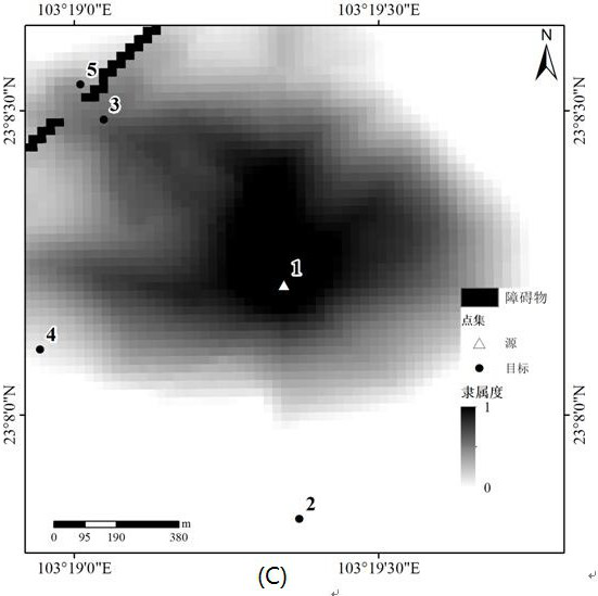
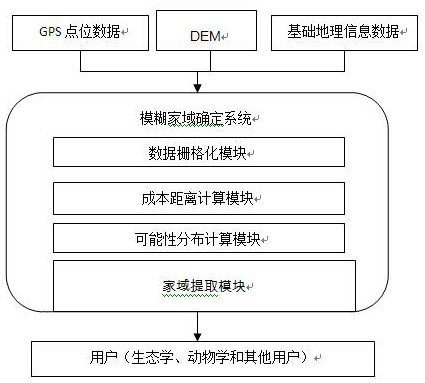
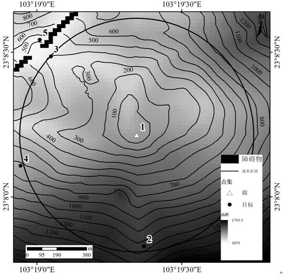
[0059] A variety of geographic information data (GPS point set, basic geographic information data, DEM data) is used as input data, among which the GPS point data set is the tracking data of animal activities; obstacles can be determined by basic geographic information data, and obstacles of different animals Animals may vary; DEM data were used to determine the impact of topography on animal activity. It should be noted that due to the diversity of animals, different animals may require different data. Rasterize the above three data with the same resolution and unify the coordinate system. Then use the cost distance calculation module to calculate the cost distance from each GPS tracking point to any point in the animal's activity area; use the possibility distribution calculation module to calculate the fuzzy probability distribution of the animal's activities in this area; use the home domain extraction module to pass The threshold is determined in advance to extract the c...
Embodiment 2
[0091] A simulated dataset such as Figure 5 Shown, the simulated animal is the sika deer, which prefers to live on the edge of forests and meadows, but not in dense forests or bushes; moreover, they prefer areas with little human disturbance, open spaces, and abundant water. The spatial resolution of the DEM data is 25m, and the elevation ranges from 689m to 2129m. In this example, the area above 1800m above sea level ( Image 6 Marked as A in ), the pond ( Image 6 Marked as B in), expressway service area ( Image 6Marked as C), expressway ( Image 6 marked D) and the farm ( Image 6 Marked as E) is considered to be an obstacle to the activities of sika deer. Since animals prefer to live on flat terrain rather than rugged and steep areas, the terrain relief obtained by DEM was used to measure the cost distance in this area. Utilize the method of the present invention, obtain the fuzzy degree of membership of the family domain of simulation data set, such as Figure 7 ...
PUM
 Abstract
Description
Claims
Application Information