Unmanned aerial vehicle for automatically measuring stream hydrological information to indicate stream crossing

An automatic measurement and unmanned aerial vehicle technology, applied in the field of navigators, can solve the problems of time-consuming and laborious manual detection, lack of tools, inconvenient detection instructions, etc., to achieve the effect of convenient detection, prevention of item loss and physical damage, and a high degree of automation

Inactive Publication Date: 2020-12-04
宁波拉修智能科技有限公司
View PDF0 Cites 1 Cited by
  • Summary
  • Abstract
  • Description
  • Claims
  • Application Information

AI Technical Summary

Problems solved by technology

[0002] When doing outdoor activities, you often encounter sudden streams. The water depth and flow velocity of the stream are uncertain, and you can’t cross the river rashly. You need to detect the flow velocity an...

Method used


Image

  • Unmanned aerial vehicle for automatically measuring stream hydrological information to indicate stream crossing
  • Unmanned aerial vehicle for automatically measuring stream hydrological information to indicate stream crossing
  • Unmanned aerial vehicle for automatically measuring stream hydrological information to indicate stream crossing

Examples


Embodiment Construction

[0016] All features disclosed in this specification, or steps in all methods or processes disclosed, may be combined in any manner, except for mutually exclusive features and / or steps.

[0017] Any feature disclosed in this specification (including any appended claims, abstract and drawings), unless expressly stated otherwise, may be replaced by alternative features which are equivalent or serve a similar purpose. That is, unless expressly stated otherwise, each feature is one example only of a series of equivalent or similar features.

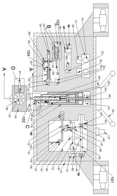
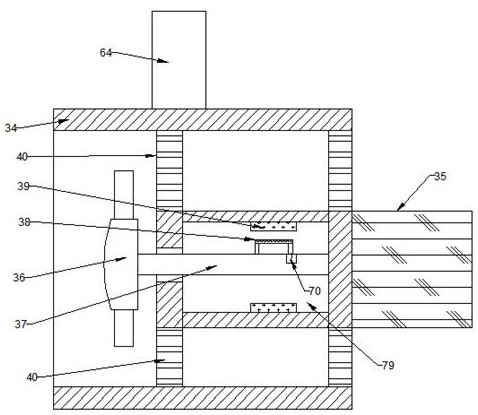
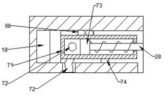
[0018] Combine below Figure 1-5 The present invention is described in detail, wherein, for the convenience of description, the orientations mentioned below are defined as follows: figure 1 The front, back, left, right, up, and down directions of the view direction are the same, figure 1 It is the front view of the device of the present invention, figure 1 The directions shown are consistent with the front, back, left, right, up, and down d...


PUM


Abstract

The invention discloses an unmanned aerial vehicle for automatically measuring stream hydrological information to indicate stream crossing, which comprises a shell. A transmission space is arranged onthe right side of the shell, an electromagnet space is arranged on the right side of the transmission space, a rack space is arranged on the left side of the shell, a recovery space is arranged on the middle side of the shell, an indicator light space is arranged on the left side of the shell, and an electromagnet sliding space is arranged at the lower side of the indicator light space. The device can detect the comprehensive information of the depth and the flow velocity of a stream segment of a stream to be crossed, can comprehensively detect the water depth and the water flow velocity to find a position most suitable for crossing the stream, and performs operation guidance through the indicator light device, a user is reminded of the actual situation, hydrological information can be conveniently detected, article loss and body injury caused by the fact that people needing to cross the river cross the river at unsuitable places are prevented, and the automation degree is high.

Description

technical field [0001] The invention relates to the field of navigators, in particular to an unmanned aerial vehicle for automatically measuring the hydrology of streams and indicating river crossing. Background technique [0002] When doing outdoor activities, you often encounter sudden streams. The water depth and flow velocity of the stream are uncertain, and you can’t cross the river rashly. You need to detect the flow velocity and depth of the stream to judge whether you can cross the river there. And the lack of tools makes it inconvenient to carry out detection instructions, and special portable tools are needed for detection guidance. [0003] Unmanned aircraft, referred to as "UAV", is an unmanned aircraft operated by radio remote control equipment and its own program control device. It is very suitable as a carrier for stream hydrological inspection tools. Contents of the invention [0004] The purpose of the present invention is to provide an unmanned aerial ve...

Claims


Application Information

Patent Timeline
IPC IPC(8): G01C13/00B64C39/02
CPCB64C39/024G01C13/006G01C13/008
Inventor 崔普泽
Owner 宁波拉修智能科技有限公司
Why Eureka
Try Eureka