Unmanned aerial vehicle route planning method based on safety cost evaluation

A route planning and UAV technology, applied in the field of UAV route planning based on safety cost assessment

Pending Publication Date: 2020-12-04
CIVIL AVIATION UNIV OF CHINA
View PDF4 Cites 4 Cited by
  • Summary
  • Abstract
  • Description
  • Claims
  • Application Information

AI Technical Summary

Problems solved by technology

Although there are many existing UAV route planning methods, there is no route planning method that can effectively take into account the safety risks caused by UAV flight to ground personnel, so that the flight route of UAV has safety attributes, as far as possible Reduce casualties on the ground from drone flights

Method used


Image

  • Unmanned aerial vehicle route planning method based on safety cost evaluation
  • Unmanned aerial vehicle route planning method based on safety cost evaluation
  • Unmanned aerial vehicle route planning method based on safety cost evaluation

Examples


Embodiment Construction

[0055] The present invention will be further described below in conjunction with the accompanying drawings and specific embodiments, but the following embodiments in no way limit the present invention.

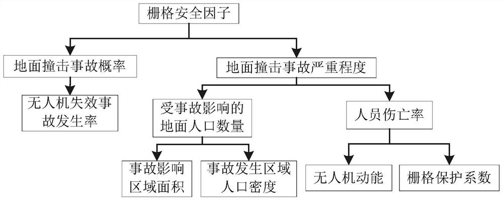
[0056] Such as figure 1 As shown, the UAV route planning method based on safety cost assessment provided by the present invention includes the following steps in order:

[0057] 1) Rasterize the ground projection of the UAV flight airspace to obtain multiple square grids;

[0058] The flight airspace of drones is determined according to the mission scope of its flight operations, and the ground projection of the flight airspace is represented by latitude and longitude coordinates in the map.

[0059] The rasterization of the ground projection of the UAV flight airspace is to divide the two-dimensional space formed by the ground projection into multiple square grids. The side length of the grid is determined by the type and design size of the drone.

[0060] The types of dro...


PUM


Abstract

The invention discloses an unmanned aerial vehicle route planning method based on safety cost evaluation. The method comprises the following steps of: rasterizing the ground projection of the flight airspace of an unmanned aerial vehicle to obtain a plurality of square grids; quantitatively describing the flight risk of the unmanned aerial vehicle in the grids by using a grid safety factor; constructing a route planning total cost expectation function based on the grid safety factor and the route distance of the unmanned aerial vehicle; and improving the ant colony algorithm by taking the airway planning total cost expectation function as a target function of the ant colony algorithm, performing iterative computation by utilizing the improved ant colony algorithm, and finally obtaining anexpected flight path after double optimization of airway safety and airway cost. According to the method of the invention, a planned unmanned aerial vehicle airway can have the function of a ground personnel safety barrier. Furthermore, the serious consequence that the unmanned aerial vehicle crashes to injure people is relieved in the strategic stage, and risk relieving is advanced.

Description

technical field [0001] The invention belongs to the technical field of UAV route planning, in particular to a UAV route planning method based on safety cost evaluation. Background technique [0002] UAV route planning refers to finding the optimal or feasible route from the starting point to the target point and satisfying the performance index of UAV under certain constraints. There are two types of existing UAV route planning technologies, one is the UAV path planning research based on expanded numerical algorithms, such as intelligent algorithms such as bionics or particle swarm optimization; the other is the path planning research based on graphical algorithms, such as the Voronoi diagram and Laguerre diagrams et al. Existing technologies include research on UAV path planning based on intelligent bionic algorithms such as ant colony and genetic algorithm, UAV path planning based on different algorithms such as gravitational search algorithm and particle swarm, and stati...

Claims


Application Information

Patent Timeline
Patent Type & Authority Applications(China)
IPC IPC(8): G01C21/20G06F17/18G06F17/15G06F16/29G06N3/00
CPCG01C21/20G06F17/18G06F17/15G06F16/29G06N3/006
Inventor 韩鹏张冰玉赵嶷飞
Owner CIVIL AVIATION UNIV OF CHINA
Why Eureka
Try Eureka