Portable geographic data remote sensing surveying and mapping device

A surveying and mapping device and geographic data technology, applied in the field of portable geographic data remote sensing surveying and mapping devices, can solve problems such as device damage, surveying and mapping personnel fatigue, contact, etc., and achieve the effects of easy movement, avoiding precision, and reducing vibration

Inactive Publication Date: 2020-12-25
LIAONING TECHNICAL UNIVERSITY
View PDF0 Cites 0 Cited by
  • Summary
  • Abstract
  • Description
  • Claims
  • Application Information

AI Technical Summary

Problems solved by technology

Remote sensing is the use of instruments sensitive to electromagnetic waves, such as remote sensors, to detect target objects and obtain their reflected, radiated or scattered electromagnetic wave information (such as electric field, magnetic field, electromagnetic wave, seismic wave, etc.) , and a science and technology of extraction, determination, processing, analysis and application. At present, remote sensing surveying and mapping is widely used in various fields such as geographic surveying and mapping. When performing geographic surveying and mapping, it is necessary to carry remote sensing surveying and mapping equipment to surveying and mapping points of different terrains for surveying and mapping , but the current surveying and mapping device usually uses a tripod, which is folded and moved by hand. When carrying out geographic surveying and mapping of mountainous forest areas, long-term hand-holding is likely to cause fatigue to the surveyors and mappers, and it is easy to cause the device to collide with trees, trees, etc. during climbing. Shrubs and other objects contact, causing damage to the device, in view of this, we propose a portable geographic data remote sensing mapping device

Method used


Image

  • Portable geographic data remote sensing surveying and mapping device
  • Portable geographic data remote sensing surveying and mapping device
  • Portable geographic data remote sensing surveying and mapping device

Examples


Embodiment 1

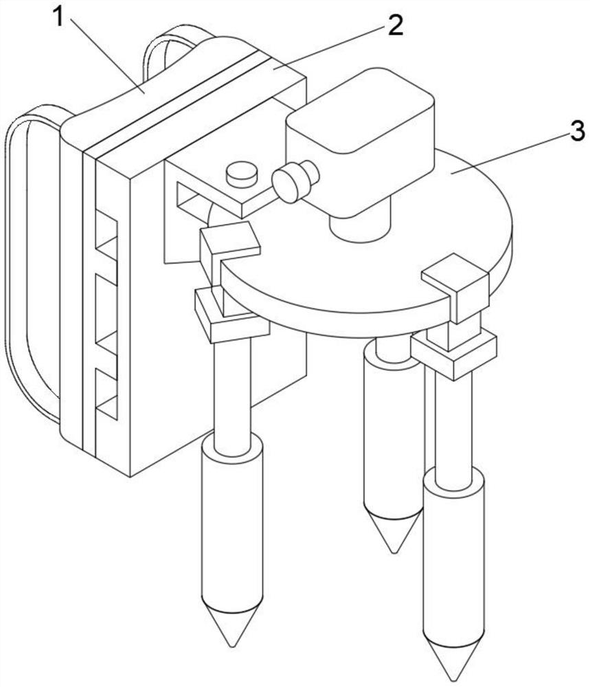
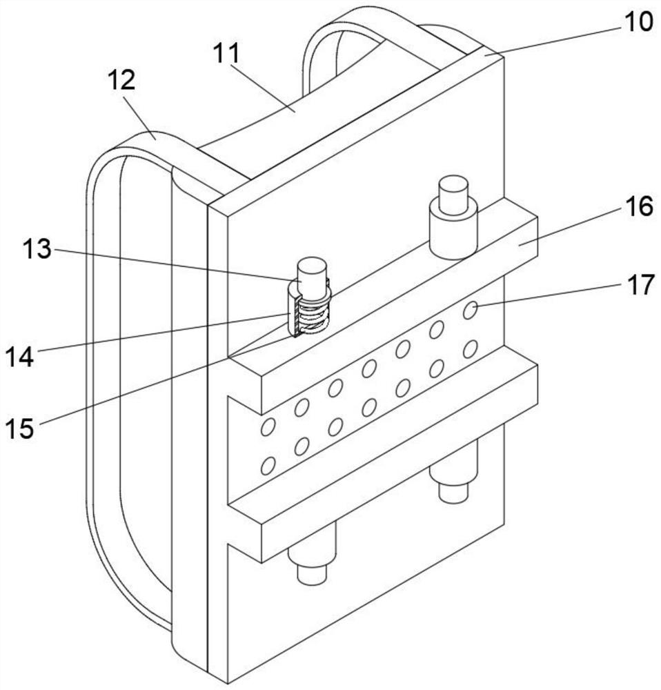
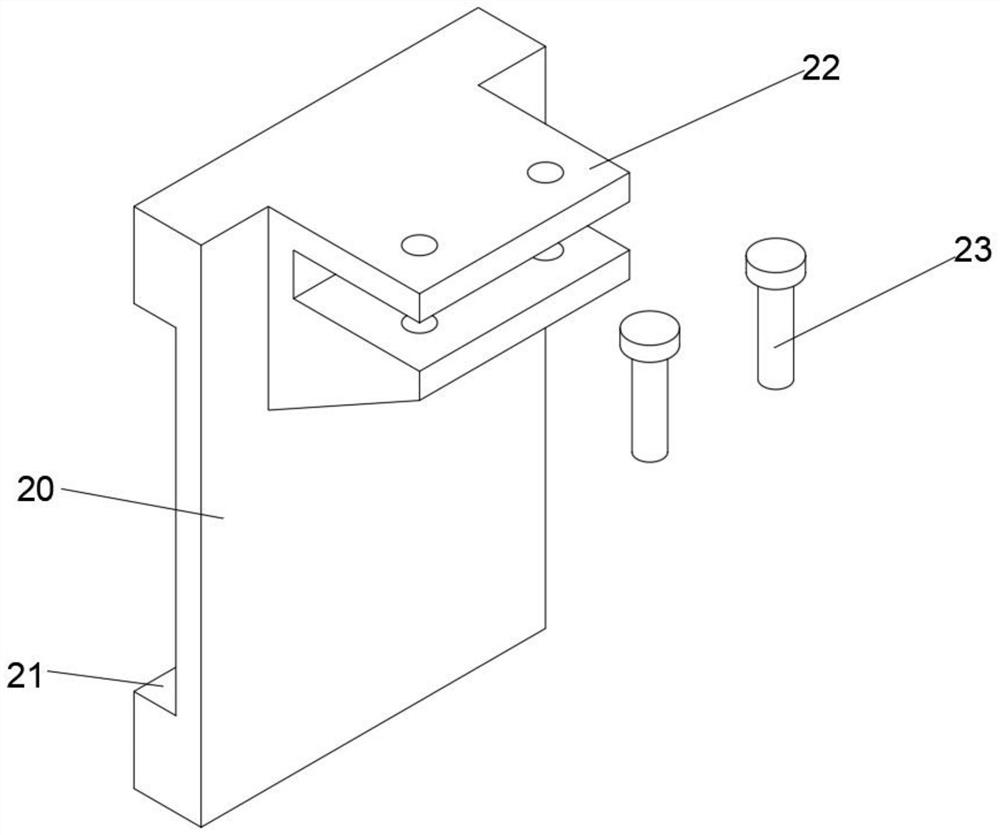
[0023] see Figure 1-Figure 4 As shown, the present invention provides a portable geographical data remote sensing surveying and mapping device, comprising a back board 1, a mounting board main body 2 and a surveying and mapping device main body 3. The main body 2 includes a mounting plate 20. The mounting plate 20 is installed on the end of the rectangular plate 10 away from the back rope 12. The end of the mounting plate 20 away from the rectangular plate 10 is integrally formed with a fixing plate 22. The main body 3 of the surveying and mapping device includes a circular plate 30, a circular plate 30 Installed on the fixed plate 22, a remote sensing surveying instrument 31 is installed on the top of the circular plate 30, and a plurality of hinged blocks 33 are connected on the circular plate 30, and the bottom ends of the hinged blocks 33 are connected with telescopic rods 35, and the bottom ends of the telescopic rods 35 are connected with threads. Pipe 36, threaded pipe...


PUM


Abstract

The invention relates to the technical field of remote sensing surveying and mapping, in particular to a portable geographic data remote sensing surveying and mapping device. The portable geographic data remote sensing surveying and mapping device comprises a bearing plate, a mounting plate body and a surveying and mapping device body; the bearing plate comprises a rectangular plate, and a back rope is installed at one end of the rectangular plate; the mounting plate body comprises a mounting plate, the mounting plate is installed at the end, away from the back rope, of the rectangular plate,and a fixing plate is integrally formed at the end, away from the rectangular plate, of the mounting plate; and the surveying and mapping device body comprises a circular plate, the circular plate isinstalled on fixing plate, remote sensing surveying instrument is installed at the top end of the circular plate, and a plurality of hinge blocks are connected with the circular plate. By arranging the bearing plate and the surveying and mapping device body, the surveying and mapping device body can be fixed to the mounting plate through bolts in the using process of the device, a user can bear the device on the back through the back rope, therefore the device is convenient to move, and the situation that when the user holds the device with hands to move and climb in a mountain forest, the device makes contact with trees, shrubs and other objects, and consequently the device is damaged is avoided.

Description

technical field [0001] The invention relates to the technical field of remote sensing surveying and mapping, in particular to a portable geographic data remote sensing surveying and mapping device. Background technique [0002] Remote sensing refers to non-contact, long-distance detection technology. Generally refers to the use of sensors / remote sensors to detect the radiation and reflection characteristics of electromagnetic waves of objects. Remote sensing is the use of instruments sensitive to electromagnetic waves such as remote sensors to detect target objects and obtain their reflected, radiated or scattered electromagnetic wave information (such as electric field, magnetic field, electromagnetic wave, seismic wave, etc.) , and a science and technology of extraction, determination, processing, analysis and application. At present, remote sensing surveying and mapping is widely used in various fields such as geographic surveying and mapping. When performing geographi...

Claims


Application Information

Patent Timeline
Patent Type & Authority Applications(China)
IPC IPC(8): G01C15/00F16F15/067
CPCF16F15/067G01C15/00
Inventor 傅春阳姜璐李浩然李孟含李渊
Owner LIAONING TECHNICAL UNIVERSITY
Why Eureka
Try Eureka