Surveying and mapping method based on municipal engineering

A municipal and engineering technology, applied in surveying and mapping and navigation, surveying instruments, surveying devices, etc., can solve the problems of unfavorable municipal engineering surveying and mapping requirements, complex surveying and mapping methods, inconvenient surveying and mapping, etc., to solve the cumbersome surveying and mapping process, improve surveying and mapping efficiency, Solve the effect of poor surveying and mapping accuracy

Active Publication Date: 2020-12-29
安徽璞石生态建设有限公司
View PDF3 Cites 4 Cited by
  • Summary
  • Abstract
  • Description
  • Claims
  • Application Information

AI Technical Summary

Problems solved by technology

[0003] The purpose of the present invention is to provide a surveying and mapping method based on municipal engineering, which is used to solve the problems that traditional surveying and mapping methods are complicated, unfavorable for municipal engineering surveying and mapping requirements, inconvenient for surveying and mapping, and low in drawing accuracy

Method used


Image

  • Surveying and mapping method based on municipal engineering

Examples


Embodiment Construction

[0047] The technical solutions of the present invention will be clearly and completely described below in conjunction with the embodiments. Apparently, the described embodiments are only some of the embodiments of the present invention, not all of them. Based on the embodiments of the present invention, all other embodiments obtained by persons of ordinary skill in the art without creative efforts fall within the protection scope of the present invention.

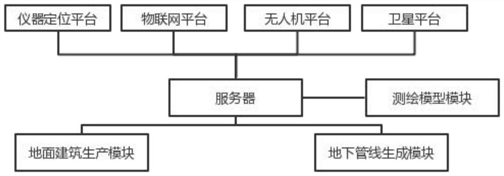
[0048] like figure 1 As shown, the steps of the surveying and mapping method include obtaining the positioning data of the instrument positioning platform; obtaining the positioning data of the Internet of Things platform; obtaining the surveying and mapping data of the UAV platform; and obtaining the surveying and mapping data of the satellite platform.

[0049] The instrument positioning platform includes surveying and mapping instruments, and the surveying and mapping instruments will input data to the instrument positio...


PUM


Abstract

The invention discloses a surveying and mapping method based on municipal engineering. The method is used for solving the problems that a traditional surveying and mapping method is complex, unfavorable for municipal engineering surveying and mapping requirements, inconvenient in surveying and mapping and low in surveying and mapping precision. The surveying and mapping method has the following beneficial effects that an unmanned aerial vehicle, an Internet of Things terminal and a satellite platform are used for solving the problems that the traditional surveying and mapping method is complexin step and needs a large number of staff surveying and mapping personnel to carry out hard surveying and mapping without resistance to wind and rain, meanwhile, the unmanned aerial vehicle, the Internet of Things terminal and the satellite platform can work uninterruptedly for 24 hours, surveying and mapping time is shortened, surveying and mapping efficiency is improved, and meanwhile, the problem that the surveying and mapping process of surveying and mapping personnel is tedious is solved; by converting a two-dimensional surveying and mapping graph into a three-dimensional surveying and mapping graph, information of constructors is more convenient to obtain, and laymen can also visually know planning of municipal engineering through a three-dimensional model; and by positioning the Internet of Things terminal, auxiliary positioning can be performed through the positioning coordinates of the Internet of Things terminal during surveying and mapping, and the problem of poor surveyingand mapping precision is solved.

Description

technical field [0001] The invention belongs to the field of civil engineering, relates to municipal surveying and mapping technology, and specifically relates to a municipal engineering-based surveying and mapping method. Background technique [0002] Surveying is all about measuring and drawing. Based on computer technology, optoelectronic technology, network communication technology, space science, and information science, with global navigation satellite positioning system (GNSS), remote sensing (RS), and geographic information system (GIS) as the technical core, the existing characteristics of the ground Points and boundaries obtain graphics and position information reflecting the current situation of the ground by means of measurement, which are used for planning, design and administrative management of engineering construction; surveying and mapping refers to the shape, size, spatial position and attributes of natural geographical elements or surface artificial facili...

Claims


Application Information

Patent Timeline
Patent Type & Authority Applications(China)
IPC IPC(8): G01C15/00G06F30/13G06T17/00
CPCG01C15/00G06F30/13G06T17/00
Inventor 沈兴禹陆华汪彤彤刘枻航刘玉龙郭家星刘哲
Owner 安徽璞石生态建设有限公司
Why Eureka
Try Eureka