Supercharge Your Innovation With Domain-Expert AI Agents!

Path planning method and system based on urban road network data

A path planning and urban road network technology, applied in the field of communication, can solve the problems of slow calculation process, complex algorithm, unsuitable for rescue vehicles to pass quickly, etc., and achieve the effect of not getting lost

Active Publication Date: 2022-06-28
BEIJING TUOMING COMM TECH
View PDF0 Cites 0 Cited by
  • Summary
  • Abstract
  • Description
  • Claims
  • Application Information

AI Technical Summary

Problems solved by technology

Due to the large amount of road network data used in the existing route planning methods (including a large number of narrow roads), the algorithm is relatively complicated, and the switching rules are often set according to the traffic flow data of the road. The calculation process of the system is relatively slow, and the planning The driving path is most likely not suitable for the rapid passage of rescue vehicles

Method used


Image

  • Path planning method and system based on urban road network data
  • Path planning method and system based on urban road network data
  • Path planning method and system based on urban road network data

Examples


Embodiment Construction

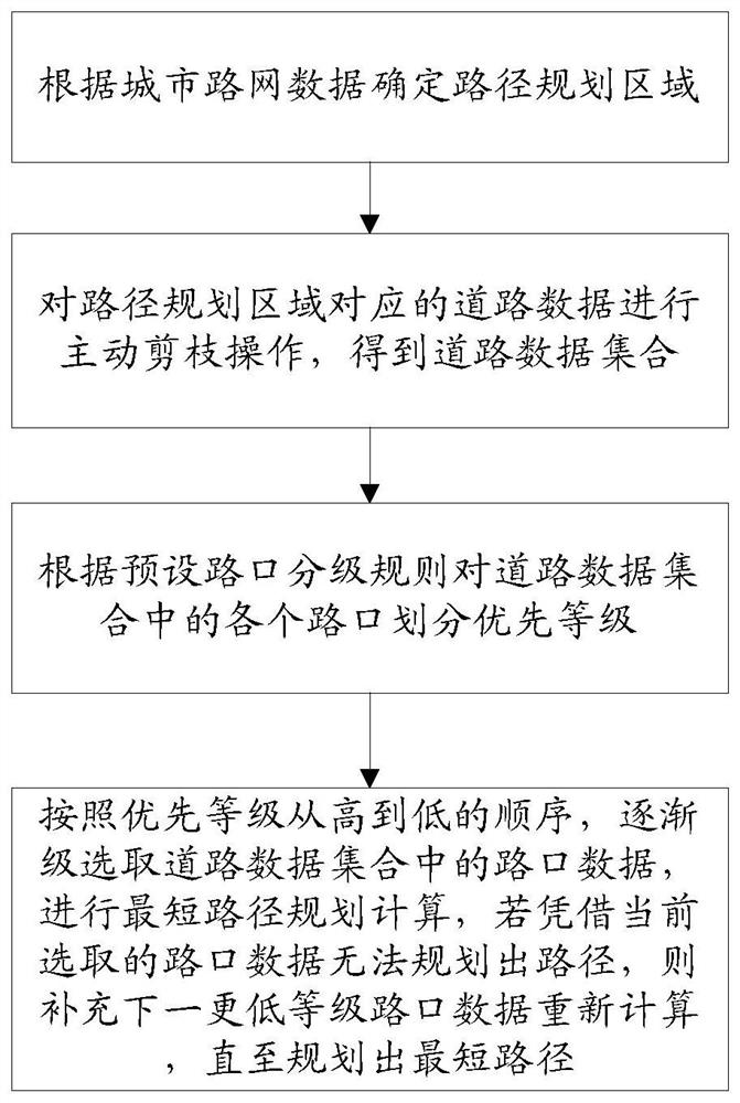
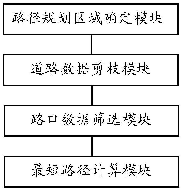
[0047] In order to make the objectives, technical solutions and advantages of the present invention clearer, the present invention will be described in detail below with reference to the accompanying drawings and embodiments. The specific embodiments described herein are only used to explain the present invention, and are not used to limit the technical solutions of the present invention.

[0048] The route planning method and system based on urban road network data of the present invention are mainly proposed for the driving characteristics of rescue vehicles in cities. my country's traffic safety law stipulates that rescue vehicles may not be subject to driving routes, driving conditions under the premise of ensuring safety. Direction, speed and signal light restrictions, other vehicles and pedestrians should give way. Therefore, short driving paths and high intersection levels are most important for the rapid passage of rescue vehicles.

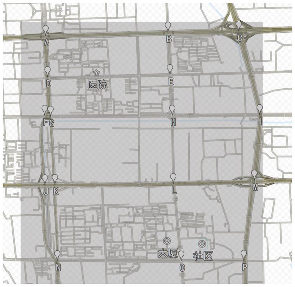
[0049] When planning the vehicle's ...


PUM


Abstract

The invention belongs to the traffic path planning technology in the field of communication technology, and in particular relates to a path planning method and system based on urban road network data. The method includes: determining the route planning area according to the urban road network data; actively pruning the road data corresponding to the route planning area to obtain a road data set; The intersection is divided into priority levels; according to the order of priority from high to low, the intersection data in the road data set are selected step by step, and the shortest path planning calculation is performed. If the path cannot be planned with the currently selected intersection data, a lower Level intersection data is recalculated until the shortest path is planned. The present invention reduces the calculation overhead in the path planning process, and can finally plan the most convenient and least lost path by selecting a simple algorithm of segment-by-segment diffusion, which is very suitable for providing driving guidance for the rapid passage of rescue vehicles.

Description

technical field [0001] The invention belongs to the traffic path planning technology in the field of communication technology, and particularly relates to a path planning method and system based on urban road network data. Background technique [0002] Path planning is to plan a moving path that satisfies the constraints according to actual needs. It has a wide range of applications in many fields, such as robot autonomous collision avoidance movement, UAV obstacle avoidance and penetration flight, GPS navigation, urban road planning, and vehicles in logistics management. configuration etc. Therefore, how to plan the path under the optimal indicators (time, distance, energy consumption, etc.) under the premise of satisfying various constraints has important theoretical value and practical significance. [0003] In the existing route planning, the shortest route is usually planned by the high computing performance cloud server of the navigation company based on the entire ma...

Claims


Application Information

Patent Timeline
Patent Type & Authority Patents(China)
IPC IPC(8): G08G1/0968
CPCG08G1/096805G08G1/096833
Inventor 何涛王志宾鲁啸
Owner BEIJING TUOMING COMM TECH
Features
  • R&D
  • Intellectual Property
  • Life Sciences
  • Materials
  • Tech Scout
  • Unparalleled Data Quality
  • Higher Quality Content
  • 60% Fewer Hallucinations
Learn More