
Method for improving ocean gravity reconstruction precision based on geoid three-dimensional correction principle

A technology of geoid and reconstruction accuracy, applied in the cross field, can solve problems such as accuracy reduction

Pending Publication Date: 2021-01-15
CHINA ACADEMY OF SPACE TECHNOLOGY
View PDF7 Cites 5 Cited by
  • Summary
  • Abstract
  • Description
  • Claims
  • Application Information

AI Technical Summary

Problems solved by technology

However, there is an inverse relationship between the accuracy and spatial resolution of marine gravity reference maps (i.e., the accuracy decreases with the increase of spatial resolution)

Method used


Image

  • Method for improving ocean gravity reconstruction precision based on geoid three-dimensional correction principle
  • Method for improving ocean gravity reconstruction precision based on geoid three-dimensional correction principle
  • Method for improving ocean gravity reconstruction precision based on geoid three-dimensional correction principle

Examples


Embodiment Construction

[0062] In order to make the object, technical solution and advantages of the present invention clearer, the embodiments disclosed in the present invention will be further described in detail below in conjunction with the accompanying drawings.

[0063] The traditional Kriging two-dimensional interpolation method (Kriging) is an optimal interpolation method named after the French Kriging DG, which comprehensively considers the relative position and relationship between the known point and the predicted point. As far as the interpolation algorithm is concerned, this method has unbiased and optimal properties. In geological statistics, the traditional Kriging two-dimensional interpolation method is usually assumed to be stable to verify the traditional kriging two-dimensional interpolation method. When reconstructing the marine gravity encryption reference map, the interpolation method can more comprehensively reflect the fluctuation of the marine gravity field. Global and local ...


PUM


Abstract

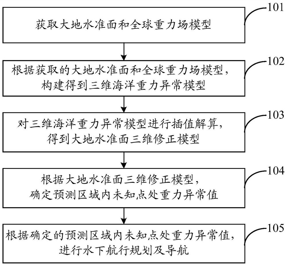
The invention discloses a method for improving ocean gravity reconstruction precision based on a geoid three-dimensional correction principle. The method comprises steps of a geoid and a global gravity field model being acquired; constructing a three-dimensional ocean gravity anomaly model according to the obtained geoid and global gravity field model; performing interpolation calculation on the three-dimensional ocean gravity anomaly model to obtain a geoid three-dimensional correction model; and according to the geoid three-dimensional correction model, determining a gravity abnormal value at an unknown point in the prediction area so as to improve the ocean gravity reconstruction precision. According to the statistical principle, prediction precision of the unknown point is improved byincreasing the amount of related information to optimize the estimated weight value, and precision loss is reduced to a large extent while the spatial resolution of the marine gravity reference map isimproved.

Description

technical field [0001] The invention belongs to the interdisciplinary technical fields of marine gravity, underwater navigation and the like, and in particular relates to a method for improving the precision of marine gravity reconstruction based on a geoid three-dimensional correction principle. Background technique [0002] Underwater gravity matching navigation generally uses auxiliary gravity feature information such as gravity anomalies or gravity gradient values ​​to correct the error accumulated by the inertial navigation system over time, thereby improving the positioning accuracy of the underwater vehicle. The underwater gravity matching navigation system consists of four key parts: gravity reference map, inertial navigation system, gravity measurement system and matching algorithm. [0003] At present, solving key technical problems such as high-precision gravity measurement system, gravity matching positioning algorithm, global high-precision and high spatial reso...

Claims


Application Information

Patent Timeline
Patent Type & Authority Applications(China)
IPC IPC(8): G01C21/20G01V7/00G06T17/00G06Q10/04G06F17/18G06F17/15
CPCG01C21/203G01V7/00G06T17/00G06Q10/04G06F17/15G06F17/18Y02A90/10
Inventor 郑伟李钊伟张文松吴凡
Owner CHINA ACADEMY OF SPACE TECHNOLOGY
Learn More