Target layer position tracking method for exploration and treatment of coal mine water disaster area

A water damage and regional technology, applied in drilling equipment and methods, earthwork drilling, directional drilling, etc., can solve the problems of complicated horizontal drilling coring process, insignificant differences in rock gamma values, and poor coring effects, etc. To achieve the effect of increasing the amount of invalid engineering and reducing the infinite expansion and uncontrollability of slurry

Active Publication Date: 2021-01-19
JIZHONG ENERGY FENGFENG GRP
View PDF5 Cites 6 Cited by
  • Summary
  • Abstract
  • Description
  • Claims
  • Application Information

AI Technical Summary

Problems solved by technology

For example, for mines with complex geological conditions, the target layer is a huge ash aquifer (generally the target layer is determined to be about 30m below the top interface of the ash aquifer), and it is very normal to encounter faults during the treatment process. When encountering faults, especially large faults or areas with insufficient geological data, how to accurately judge whether the drilling trajectory is in the designed target layer, the current technical methods are generally through rock powder identification, rock gamma value or coring, but The Ordovician limestone formation is a very thick aquifer (nearly 600m), and the difference in gamma value of the rock formation is not obvious, and the rock powder of the rock formation is difficult to accurately judge and identify.

Method used


Image

  • Target layer position tracking method for exploration and treatment of coal mine water disaster area
  • Target layer position tracking method for exploration and treatment of coal mine water disaster area
  • Target layer position tracking method for exploration and treatment of coal mine water disaster area

Examples


Embodiment Construction

[0019]The specific embodiments of the present invention will be described in detail below with reference to the accompanying drawings, but they are not used to limit the protection scope of the present invention.

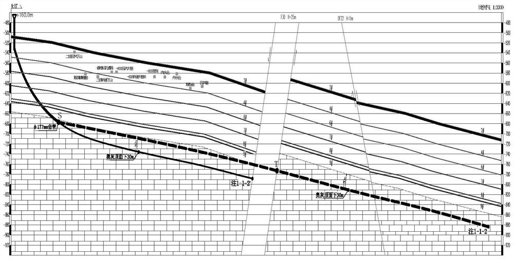
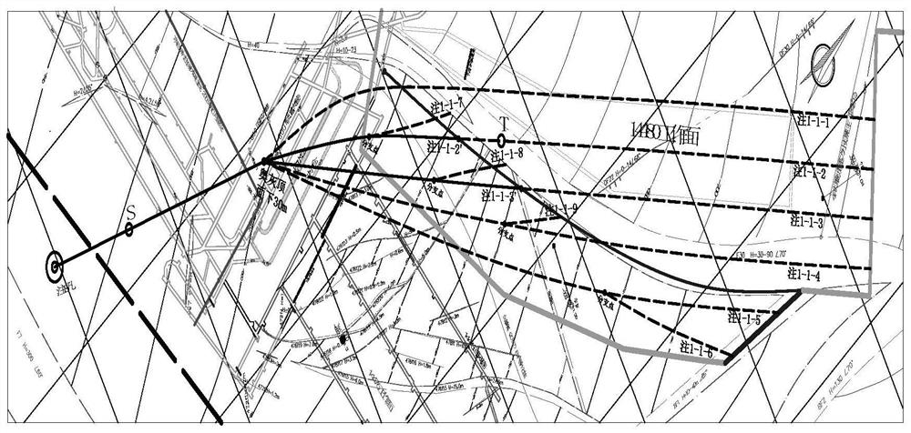
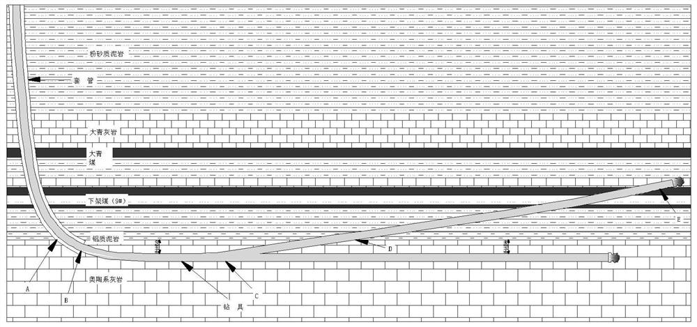
[0020]SeeFigure 1-4In this embodiment, a target layer tracking method for the exploration and treatment of coal mine water hazard areas includes the following steps: step 1, distinguish whether the fault location and drop have been determined; step 2, if it is not in the case of step 1, Either one, determine whether it belongs to the situation of insufficient or lack of geological data; step 3, follow the results of steps 1 and 2 to track the target layer.

[0021]Among them, step 3 includes:

[0022]Step 31: For the situation that the fault location and the drop have been determined, after the horizontal hole is constructed to the predetermined location of the fault, grouting is performed to seal the hole, and then, according to the fault occurrence and the target layer position ...


PUM


Abstract

The invention provides a target layer position tracking method for exploration and treatment of a coal mine water disaster area. The target layer position tracking method comprises the following stepsthat step 1, whether the fault position and fall are determined or not is distinguished; step 2, if the geological data does not belong to any one of the conditions in the step 1, whether the geological data is insufficient or deficient or not is determined; and step 3, target layer position tracking is performed according to the judgment results in the step 1 and the step 2. According to the target layer position tracking method for exploration and treatment of the coal mine water disaster area, the problem of how to reach the designed layer position of a drilling track under the condition of insufficient or deficient fault and geological data in the ground area exploration and treatment process of a mine with a complex geological structure is solved, the technical problem that the drilling can be kept in the designed target layer to continue drilling and reach the designed drilling rate is effectively solved, the drilling track is effectively prevented from deviating from the designed position, a large amount of grout waste and invalid grouting caused by infinite expansion and uncontrollability of grout are reduced, area governance is ensured to achieve the design purpose, and the target layer position tracking method is a beneficial supplement and improvement for the coal mine ground area governance technology.

Description

Technical field[0001]The present invention relates to the technical field of coal mine water hazard prevention and control, in particular to a method for tracking the position of a target layer and the position of the target layer used in the exploration and management of coal mine water hazard areas.Background technique[0002]Coal mine water damage area exploration and treatment technology is a new water prevention technology pioneered by Jizhong Energy Fengfeng Group. It solves the current technical problems of water prevention and control that restrict large mining depths, high pressure and lower coal mining. The use of this technology can liberate a large number of victims. The water-threatening coal reserves and extending the service life of the mine have significant economic and social benefits. However, there are still many aspects of this technology that need to be continuously improved and supplemented in practice and development. For example, for a mine with complex geologi...

Claims


Application Information

Patent Timeline
Patent Type & Authority Applications(China)
IPC IPC(8): E21B7/04E21B7/06
CPCE21B7/04E21B7/046E21B7/06
Inventor 关永强赵章刘存玉张会松张朋靳子栋关世盟何继刚郭江
Owner JIZHONG ENERGY FENGFENG GRP
Why Eureka
Try Eureka