Man-made forest space pattern recognition method based on time sequence classification and space analysis

A technology of spatial analysis and recognition methods, applied in character and pattern recognition, instruments, computer components, etc., can solve the problems of lack of data support, continuous information, and lack of sufficient spatial information for historical information recognition

Inactive Publication Date: 2021-02-19
NANJING FORESTRY UNIV
View PDF2 Cites 4 Cited by
  • Summary
  • Abstract
  • Description
  • Claims
  • Application Information

AI Technical Summary

Problems solved by technology

[0004] Conventional field survey techniques cannot realize the positioning of the continuous spatial and temporal distribution of plantations. First, there is a lack of sufficient spatial information. Second, the time span of data acquisition is too large to achieve continuous monitoring.
The operating costs of high-resolution technology and lidar technology are too high to meet the needs of large-scale areas, and there is a lack of data support for the identification of historical information
The long-sequence Landsat satellite image Landsat can realize time-series monitoring, but the data is often affected by clouds, shadows, haze, etc., and is more limited by weather conditions
Synthetic aperture radar, such as L-band PALSAR images, is greatly affected by data timeliness and discontinuity
Moreover, the identification of afforestation and continuous non-forest usually requires long-term data as support to capture many subtle changes. Discontinuous data will lose a lot of sudden or gradual changes and continuous information, which will affect the accuracy of the results.
Many existing technologies define the distribution of planted forests by judging the distribution profile of planted forests, the color and regularity of trees, and do not rely on the advantages of long-term and multi-source data to carry out research work

Method used


Image

  • Man-made forest space pattern recognition method based on time sequence classification and space analysis
  • Man-made forest space pattern recognition method based on time sequence classification and space analysis
  • Man-made forest space pattern recognition method based on time sequence classification and space analysis

Examples


Embodiment 1

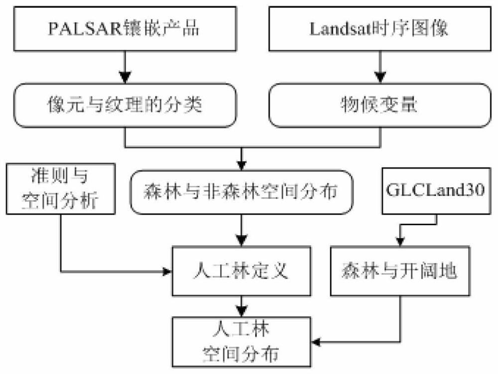
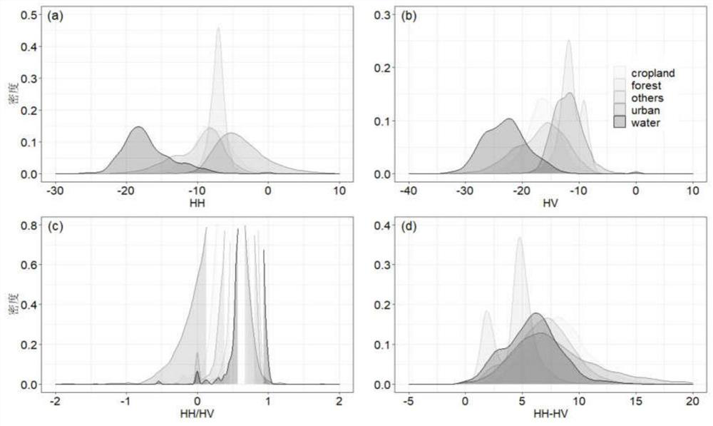
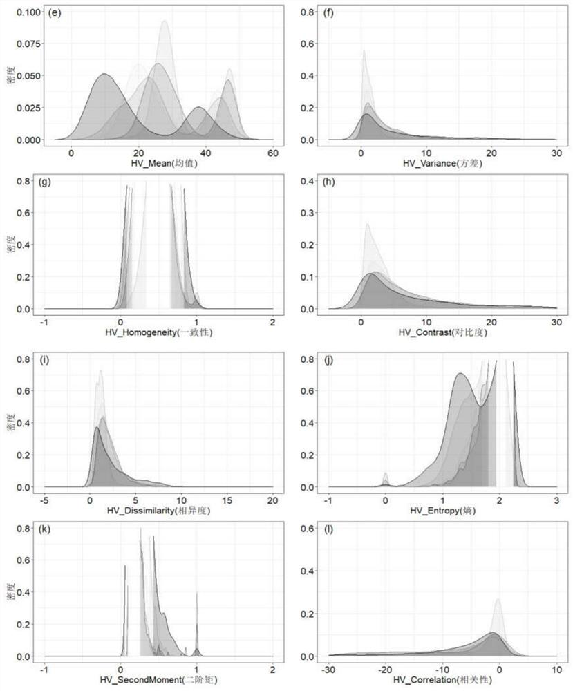
[0035] Such as figure 1The shown plantation spatial pattern recognition method based on time-series classification and spatial analysis includes the following steps: First, collect the available Landsat data and PALSAR data, and perform stochastic gradient boosting to classify land cover types based on the polarization and texture of PALSAR, and then Obtain the NDVI time series based on Landsat, and obtain the threshold for distinguishing forests and non-forests, then combine the classification results obtained by PALSAR to generate the final forest and non-forest products, and combine the methods of knowledge discrimination and spatial analysis to finally generate the spatial distribution of plantations.

[0036] 1) Data acquisition

[0037] Taking northern Guangdong p122r043 as an example, the PALSAR image mosaic dataset (2007-2016) was obtained from JAXA, Japan, and the Landsat TM / ETM+ / OLI remote sensing images from 1986-2016 were obtained from the USGS. Obtain Landsat dat...


PUM


Abstract

The invention discloses a man-made forest spatial pattern recognition method based on time sequence classification and spatial analysis, and belongs to the technical field of forest classification andrecognition. According to the method, on the basis of multi-source remote sensing data collection and preprocessing, field measured data are combined, backward scattering features for identifying land cover categories are extracted from a multi-year PALSAR image, and vegetation index NDVI cumulative maximum values of different land cover categories are extracted from a multi-temporal Landsat image for phenological feature identification; by integrating forest and non-forest products obtained by the former and forest and non-forest category discrimination thresholds of the latter, a single forest resource category identification model is constructed and extended to consecutive years, and spatial distribution identification of the artificial forest is realized by combining decision discrimination, knowledge criteria and spatial overlay analysis. Compared with a traditional field investigation shape identification and area statistics mode, the method shows clear space-time significance characteristics.

Description

technical field [0001] The invention belongs to the technical field of forest classification and identification, and in particular relates to a plantation forest spatial pattern recognition method based on time series classification and spatial analysis. Background technique [0002] How to quantitatively and accurately identify the spatial distribution of large-scale continuous plantations is a key part of terrestrial carbon accounting research. It has important practical significance in forest carbon sink measurement. The traditional method of statistical identification of planted forest area mainly relies on national, local and special field surveys of forest resources or in combination with aerial photos, through the combination of early interpretation and field surveys. These methods are time-consuming and labor-intensive. On the one hand, they cannot provide space. Pattern distribution map, on the other hand, the recognition accuracy is more subject to human intervent...

Claims


Application Information

Patent Timeline
Patent Type & Authority Applications(China)
IPC IPC(8): G06K9/00G06K9/32G06K9/40G06K9/46G06K9/62
CPCG06V20/188G06V10/30G06V10/25G06V10/44G06F18/2415
Inventor 沈文娟黄成全李明诗
Owner NANJING FORESTRY UNIV
Why Eureka
Try Eureka