SINS/BDS integrated navigation system air alignment method based on finite time sliding mode

An integrated navigation system, limited time technology, applied in the field of integrated navigation, achieves superior convergence ability, overcomes noise that is difficult to estimate, and ensures robustness

Pending Publication Date: 2021-02-23
YANGZHOU UNIV
View PDF0 Cites 1 Cited by
  • Summary
  • Abstract
  • Description
  • Claims
  • Application Information

AI Technical Summary

Problems solved by technology

There are still many deficiencies in the Kalman filter, and the application of the Kalman filter is subject to some r

Method used


Image

  • SINS/BDS integrated navigation system air alignment method based on finite time sliding mode
  • SINS/BDS integrated navigation system air alignment method based on finite time sliding mode
  • SINS/BDS integrated navigation system air alignment method based on finite time sliding mode

Examples


Embodiment Construction

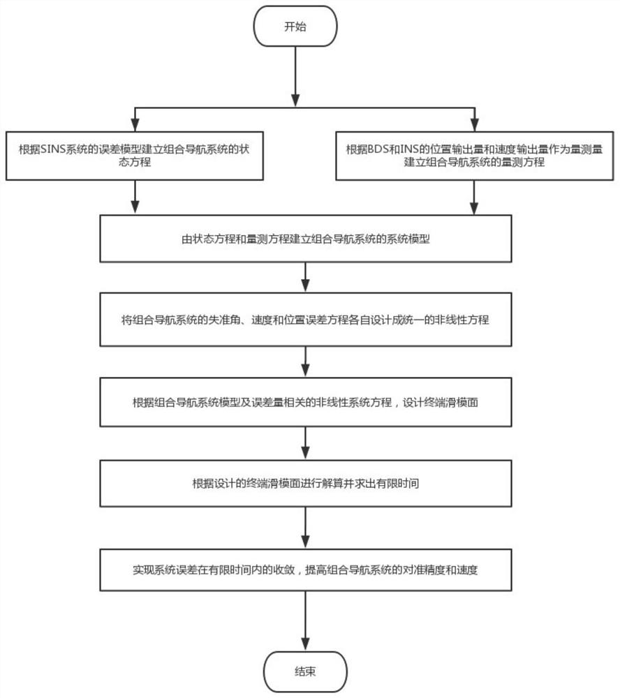
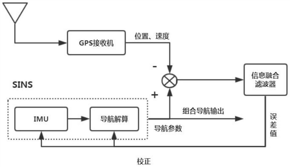
[0043] Such as figure 1 and 2 As shown, a SINS / BDS integrated navigation system air alignment method based on finite time sliding mode, the specific implementation steps are as follows:

[0044] Step 1, according to the error model of SINS and the position output and speed output obtained respectively by the SINS inertial sensitive device and the BDS receiver as observations, establish the system model of the SINS / BDS integrated navigation system;

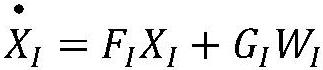
[0045] In a further embodiment, the state equation of the integrated navigation system is established according to the platform misalignment angle error equation, velocity error equation, position error equation, gyroscope drift error model and accelerometer error model of the SINS system.

[0046]In a specific embodiment, consider the error state vector of 15 dimensions, set the navigation coordinate system as east (E), north (N), day (U) coordinate system, the error state vector is as follows:

[0047]

[0048] In the formul...


PUM


Abstract

The invention discloses an SINS/BDS integrated navigation system air alignment method based on a finite time sliding mode. Finite time and a sliding mode variable structure are combined to be appliedto an integrated navigation system according to a formed system model. Aiming at a system error model of the integrated navigation system, a terminal sliding mode surface based on the finite time is designed, and convergence time of an error amount of the integrated navigation system based on the finite time sliding mode is calculated and solved so that the error amount of the integrated navigation system is rapidly converged within the finite time, and rapid and accurate navigation of the integrated navigation system is realized. The navigation precision and the alignment speed of the integrated navigation system are further improved within the finite time, and the navigation performance of the integrated navigation system is improved.

Description

technical field [0001] The invention belongs to the technical field of integrated navigation, in particular to an air alignment method for a SINS / BDS integrated navigation system based on a finite time sliding model. Background technique [0002] In recent years, with the rapid development of information technology, the navigation system is also undergoing rapid changes. There are two most well-known navigation systems at present, one is the strapdown inertial navigation system (SINS), and the other is the satellite positioning system. With the complete networking of my country's Beidou Satellite Navigation System (BDS), the Beidou Satellite Navigation System has become a leader in navigation systems. The inertial navigation system is a navigation technology based on Newton's theorem, which uses inertial sensitive devices to measure the real-time information of the carrier for calculation, and obtains information such as the carrier's attitude, position, and speed. It is a...

Claims


Application Information

Patent Timeline
IPC IPC(8): G01C25/00G01S19/40G01S19/49
CPCG01C25/005G01S19/40G01S19/49
Inventor 曹松银尤杰高红莲张远飞
Owner YANGZHOU UNIV
Why Eureka
Try Eureka