Full-digital simulation method and device for global positioning system (GPS)/strapdown inertial navigation system (SINS) combined navigation

A technology of all-digital simulation and integrated navigation, applied in the field of full-digital simulation of GPS/SINS integrated navigation, which can solve the problems of restricting the popularization and application of GPS/SINS integrated system

Inactive Publication Date: 2012-06-20
TIANJIN UNIV
View PDF4 Cites 34 Cited by
  • Summary
  • Abstract
  • Description
  • Claims
  • Application Information

AI Technical Summary

Problems solved by technology

This, to a certain extent, limits the popularization and application of the GPS / SINS combined system, especially in the civil field

Method used


Image

  • Full-digital simulation method and device for global positioning system (GPS)/strapdown inertial navigation system (SINS) combined navigation
  • Full-digital simulation method and device for global positioning system (GPS)/strapdown inertial navigation system (SINS) combined navigation
  • Full-digital simulation method and device for global positioning system (GPS)/strapdown inertial navigation system (SINS) combined navigation

Examples


Embodiment Construction

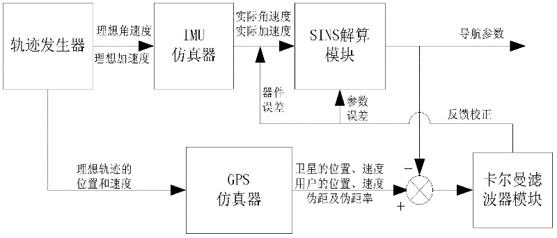
[0040] The purpose of the present invention is to provide a full digital simulation system of GPS / SINS integrated navigation system. The simulation system can replace the actual GPS / SINS integrated navigation system to verify the influence of various software algorithms in integrated navigation on navigation accuracy and develop new algorithms; at the same time, these verified algorithms and new developed algorithms can be loaded It is applied in the actual GPS / SINS integrated navigation system; the present invention has an important guiding function and practical significance on how to improve the navigation accuracy of the low-cost GPS / SINS integrated navigation system. The present invention mainly completes the following functions:

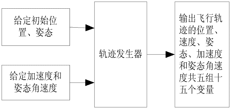
[0041] 1. The trajectory generator provides the flight trajectory data required by the entire integrated navigation simulation system.

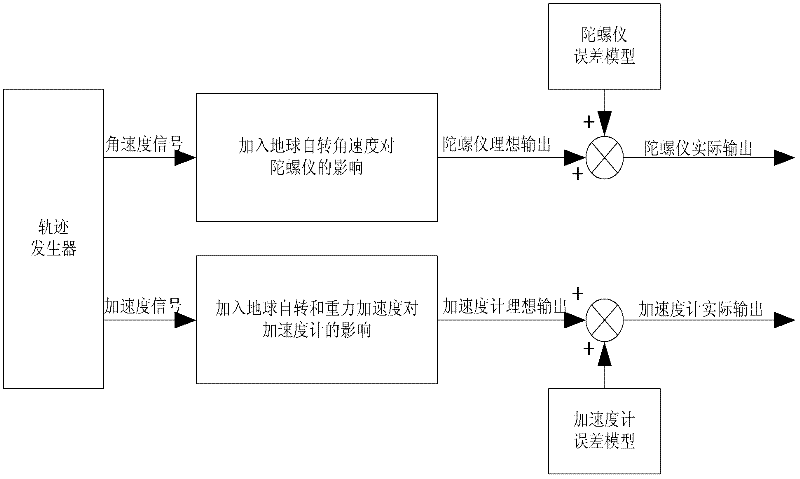
[0042] 2. The IMU emulator simulates the real output of the gyroscope and accelerometer.

[0043] 3. The ...


PUM


Abstract

The invention belongs to the field of combined navigation. In order to provide a low-cost and high-precision navigation device and a low-cost and high-precision navigation method, the technical scheme adopted by the invention is as follows: a full-digital simulation device for global positioning system (GPS)/strapdown inertia navigation system (SINS) combined navigation is composed of a trace generator module, an inertial measurement unit (IMU) simulator, a GPS simulator, an SINS calculation module and a Kalman filter module, wherein the trace generator module is used for generating flying trace data; the IMU simulator is used for simulating the actual situations of a gyroscope and an accelerator; the GPS simulator is used for simulating a GPS receiver and outputting the pseudorange, pseudorange rate, position and speed information of a carrier; the SINS calculation module is used for calculating the outputs of the IMU simulator to acquire the position, speed and attitude information of the carrier; and the Kalman filter module is used for performing data fusion on a GPS and an SINS by adopting a Kalman filter method according to two different combination modes, namely loose combination and compact combination. The device and the method are mainly applied to navigation.

Description

technical field [0001] The invention belongs to the field of integrated navigation, specifically relates to a GPS / SINS integrated navigation full digital simulation method and device, and has important significance for the design and scheme demonstration of an actual integrated navigation system. Background technique [0002] In order to obtain the real-time position, velocity and attitude information of the mobile carrier, various navigation methods have been proposed and adopted. Among them, the Strapdown Inertial Navigation System (SINS) and the Global Positioning System (GPS) are most widely used. [0003] SINS can not only provide the position and velocity parameters of the carrier, but also provide the three-dimensional attitude parameters of the carrier. It is a completely autonomous navigation method and has been widely used in almost all fields such as aviation, aerospace, navigation and land. However, the disadvantage of SINS that is difficult to overcome is that ...

Claims


Application Information

Patent Timeline
Patent Type & Authority Applications(China)
IPC IPC(8): G06F17/50
Inventor 宗群吴宏硕田栢苓侯志宁廖海林
Owner TIANJIN UNIV
Why Eureka
Try Eureka