Photographing point positioning method based on unmanned aerial vehicle and related device
A UAV, point positioning technology, applied in image data processing, instruments, calculations, etc., can solve problems such as spatial position uncertainty, reduce the efficiency of three-dimensional route planning, and achieve the effect of efficient automatic positioning
- Summary
- Abstract
- Description
- Claims
- Application Information
AI Technical Summary
Problems solved by technology
Method used
Image
Examples
Embodiment Construction
[0048] The core of the present invention is to provide a method for locating photographing points based on an unmanned aerial vehicle. In the prior art, it is usually only manually calibrated to calibrate the position where the drone needs to fly in the 3D point cloud. The process of manual calibration will bring the uncertainty of the spatial position, and manually setting the camera position and camera parameters of each 3D point greatly reduces the efficiency of 3D route planning.
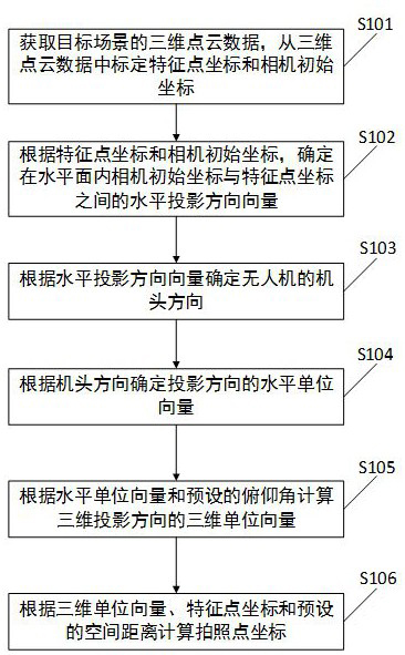
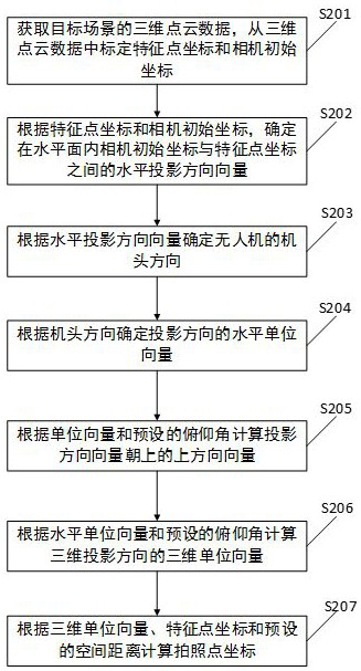
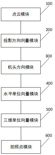
[0049] And a kind of UAV-based photo point location method provided by the present invention, comprises acquiring the 3D point cloud data of target scene, demarcating feature point coordinates and camera initial coordinates from 3D point cloud data; According to feature point coordinates and camera initial coordinates Coordinates, determine the horizontal projection direction vector between the initial camera coordinates and the feature point coordinates in the horizontal plane; determine the no...
PUM
 Abstract
Description
Claims
Application Information
 - R&D
- Intellectual Property
- Life Sciences
- Materials
- Tech Scout
- Unparalleled Data Quality
- Higher Quality Content
- 60% Fewer Hallucinations
Browse by: Latest US Patents, China's latest patents, Technical Efficacy Thesaurus, Application Domain, Technology Topic, Popular Technical Reports.
© 2025 PatSnap. All rights reserved.Legal|Privacy policy|Modern Slavery Act Transparency Statement|Sitemap|About US| Contact US: help@patsnap.com


