Urban road supervision method and system based on unmanned aerial vehicle navigation following and readable storage medium

A UAV, road technology, applied in the control/adjustment system, two-dimensional position/channel control, motor vehicles and other directions, to achieve the effect of clear on-site picture and ensure traffic efficiency

Inactive Publication Date: 2021-03-09
广东竞合基业科技服务有限公司
View PDF0 Cites 5 Cited by
  • Summary
  • Abstract
  • Description
  • Claims
  • Application Information

AI Technical Summary

Problems solved by technology

[0003] In order to achieve precise control of urban road supervision, it is necessary to develop a matching system for control. The system collects traffic image information through aerial photography of drones, obtains traffic flow data, and uses network models to identify traffic incident categories. Generate guidance information according to the traffic event category, and guide the vehicle path in real time. During the real-time guidance process, the UAV intelligently follows and determines the UAV reference track according to the vehicle path. When the UAV’s current flight path deviates from the reference flight During the trajectory, the flight path of the UAV is dynamically adjusted, but in the process of control, how to achieve precise control and at the same time realize the precise and dynamic supervision of the road is an urgent problem to be solved

Method used


Image

  • Urban road supervision method and system based on unmanned aerial vehicle navigation following and readable storage medium
  • Urban road supervision method and system based on unmanned aerial vehicle navigation following and readable storage medium
  • Urban road supervision method and system based on unmanned aerial vehicle navigation following and readable storage medium

Examples


Embodiment Construction

[0087] In order to understand the above-mentioned purpose, features and advantages of the present invention more clearly, the present invention will be further described in detail below in conjunction with the accompanying drawings and specific embodiments. It should be noted that, in the case of no conflict, the embodiments of the present application and the features in the embodiments can be combined with each other.

[0088] In the following description, many specific details are set forth in order to fully understand the present invention. However, the present invention can also be implemented in other ways different from those described here. Therefore, the protection scope of the present invention is not limited by the specific details disclosed below. EXAMPLE LIMITATIONS.

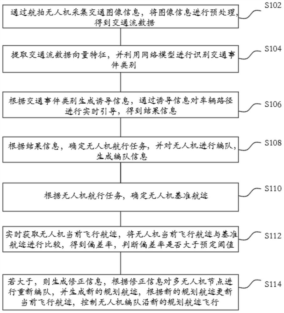
[0089] figure 1 It shows a flowchart of an urban road supervision method based on drone navigation and following in the present invention.

[0090] Such as figure 1 As shown, the first aspect of t...


PUM


Abstract

The invention relates to an urban road supervision method and system based on unmanned aerial vehicle navigation following, and a readable storage medium, and the method comprises the steps: collecting traffic image information through an aerial photography unmanned aerial vehicle, extracting traffic flow data vector features, and recognizing the types of traffic events through a network model; generating induction information according to the traffic event category, performing real-time guidance on the vehicle path through the induction information to obtain result information, determining anunmanned aerial vehicle navigation task, performing formation on the unmanned aerial vehicles, and determining an unmanned aerial vehicle reference track according to the unmanned aerial vehicle navigation task; acquiring a current flight path of the unmanned aerial vehicle in real time, and comparing the current flight path of the unmanned aerial vehicle with the reference flight path to obtaina deviation ratio; judging whether the deviation ratio is greater than a preset threshold value or not; if yes, generating correction information, reforming the multiple unmanned aerial vehicle nodesaccording to the correction information, generating a new planned flight path, updating the current flight path according to the new planned flight path, and controlling the unmanned aerial vehicle formation to fly along the new planned flight path.

Description

technical field [0001] The present invention relates to an urban road supervision method, in particular to an urban road supervision method, system and readable storage medium based on navigation and follow-up of a drone. Background technique [0002] As a negative externality product of urbanization overflow, traffic congestion has always been the focus of attention from all walks of life in the world. As an important part of the intelligent transportation system, intersection signal control and path guidance are being used more and more widely in the increasingly severe traffic environment. However, with the rapid development and improvement of hardware facilities, the problem of low intelligence of the traffic management system still exists. In the data, obtain hidden internal information, and make full use of information advantages to formulate scientific grooming strategies and other issues. Therefore, on the basis of massive traffic data, it is of great significance ...

Claims


Application Information

Patent Timeline
Patent Type & Authority Applications(China)
IPC IPC(8): G05D1/02
CPCG05D1/0221G05D1/0223G05D1/0251G05D1/0276G05D2201/0206
Inventor 付骏宇刘立斌耿鹏
Owner 广东竞合基业科技服务有限公司
Why Eureka
Try Eureka