An Intelligent 3D Mapping Method for Buildings Based on Multi-source Remote Sensing Data

A technology of 3D mapping and remote sensing data, applied in image data processing, image analysis, image enhancement, etc., can solve the problem of many data source requirements, and achieve the effect of meeting accuracy requirements, saving time and labor costs

Active Publication Date: 2022-05-17
WUHAN UNIV
View PDF8 Cites 0 Cited by
  • Summary
  • Abstract
  • Description
  • Claims
  • Application Information

AI Technical Summary

Problems solved by technology

The disadvantage of this method is that manual interactive editing is required to achieve precise line feature constraints, and there are more requirements for data sources

Method used


Image

  • An Intelligent 3D Mapping Method for Buildings Based on Multi-source Remote Sensing Data
  • An Intelligent 3D Mapping Method for Buildings Based on Multi-source Remote Sensing Data
  • An Intelligent 3D Mapping Method for Buildings Based on Multi-source Remote Sensing Data

Examples


Embodiment Construction

[0127] The technical solutions of the present invention will be described in detail below in conjunction with the accompanying drawings and embodiments.

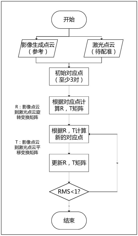
[0128] The invention is an automatic three-dimensional mapping method and system based on multi-source remote sensing data. First, the laser point cloud in the survey area is registered and fused with the image dense point cloud generated by the high-precision aerial remote sensing image data spatial three-dimensional dense matching to ensure the consistency of the two in three-dimensional coordinates. Use the registered 3D point cloud data to perform high-precision interpolation to generate a high-precision DSM model, filter the DSM to obtain the DEM model of the target survey area, combine DEM, DSM model and original aerial remote sensing image data and its corresponding high-precision Orientation parameter generation preserves the traditional DOM image and high-precision OESM model with strict collinear relationship. The...


PUM


Abstract

The invention discloses an intelligent three-dimensional mapping method for buildings based on multi-source remote sensing data, which uses the aerial remote sensing image data and laser point cloud data of the target survey area to obtain the building roof vector profile of the target survey area through the following steps , Structured 3D wireframe model of buildings. The present invention uses aerial remote sensing image data to generate image three-dimensional point cloud, and completes high-precision registration and fusion of image point cloud and laser point cloud; uses the fused three-dimensional point cloud to generate high-precision DSM, DEM, traditional DOM and OESM models; uses three-dimensional The point cloud extracts the building boundary, extracts the contour line on the DOM, and combines the two to extract and filter the two-dimensional vector contour of the building to achieve high-precision extraction of the building roof contour; based on the two-dimensional vector contour of the building roof and high-precision OESM Model quickly generates a structured wireframe 3D model of a building. The invention does not need manual intervention, and realizes fully automatic three-dimensional mapping of buildings.

Description

technical field [0001] The invention belongs to the field of three-dimensional mapping of buildings, in particular to an intelligent three-dimensional mapping method for buildings based on multi-source remote sensing data. Background technique [0002] The production efficiency of the traditional stereo mapping method is low, and it takes a lot of labor and time to realize the semi-automatic extraction of building outline information by manual intervention. Most of the existing 3D modeling methods for large-scale buildings are based on large-scale point cloud information for network reconstruction, which has high computational complexity, and the generated models do not have structured information, and it is desired to obtain a single 3D model of the building raletively hard. [0003] The Chinese patent with the publication number CN109685891A applied for a 3D building modeling and virtual scene generation system based on depth images. The patent implementation method inclu...

Claims


Application Information

Patent Timeline
Patent Type & Authority Patents(China)
IPC IPC(8): G06T17/05G06T17/20G06T7/33G06T7/13G06T7/168G06T7/11G06T7/187
CPCG06T17/05G06T17/20G06T7/337G06T7/13G06T7/168G06T7/11G06T7/187G06T2207/10032G06T2207/10028G06T2207/20061G06T2200/08
Inventor 肖雄武钟智超李德仁陈隽展于丁张卫龙
Owner WUHAN UNIV
Why Eureka
Try Eureka