Lane boundary interactive extraction method based on vehicle-mounted point cloud data

A point cloud data and lane boundary technology, applied in character and pattern recognition, instruments, computer components, etc., can solve the problems of unpredictable distribution, high time cost, and inability to be widely used, so as to reduce complexity and improve data processing Efficiency and the effect of improving extraction accuracy

Pending Publication Date: 2021-03-26
SUZHOU IND PARK SURVEYING MAPPING & GEOINFORMATION CO LTD
View PDF0 Cites 8 Cited by
  • Summary
  • Abstract
  • Description
  • Claims
  • Application Information

AI Technical Summary

Problems solved by technology

The results extracted by the automatic extraction method inevitably have incorrect extraction and unsatisfactory accuracy. The distribution of these problem results is difficult to predi

Method used


Image

  • Lane boundary interactive extraction method based on vehicle-mounted point cloud data
  • Lane boundary interactive extraction method based on vehicle-mounted point cloud data
  • Lane boundary interactive extraction method based on vehicle-mounted point cloud data

Examples


Embodiment Construction

[0063] The present invention will be further described below in conjunction with the accompanying drawings and specific embodiments, so that those skilled in the art can better understand the present invention and implement it, but the examples given are not intended to limit the present invention.

[0064] In the description of the present invention, the term "comprising" is intended to cover a non-exclusive inclusion, for example, a process, method, system, product or device comprising a series of steps or units, not limited to the listed steps or units but Optionally also include steps or elements not listed, or optionally also include other steps or elements inherent to the process, method, product or apparatus.

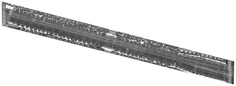
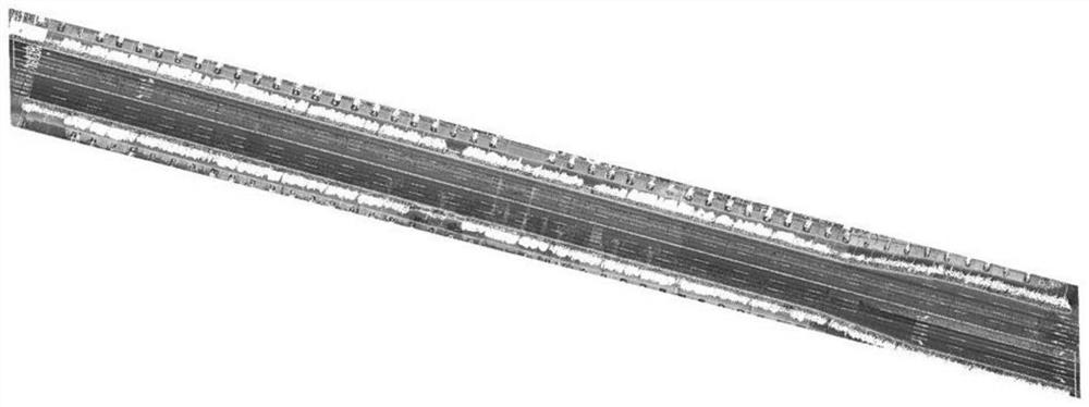
[0065] refer to figure 1 As shown in the flow chart, a kind of embodiment of the lane boundary interactive extraction method based on vehicle-mounted point cloud data of the present invention comprises the following steps:

[0066] Step 1: Obtain the initial veh...


PUM


Abstract

The invention discloses a lane boundary interactive extraction method based on vehicle-mounted point cloud data. The method comprises the steps of obtaining a vehicle-mounted point cloud data set, manually selecting an initial direction, training sample data, identifying and denoising lane boundary point cloud, extracting and denoising a lane boundary center line, and fitting and extracting a vector boundary; and taking two ends of a fitting vector boundary as a new starting point and an extension direction, repeating the following steps of training the sample data until a new lane boundary cannot be obtained, and obtaining the lane boundary of the vehicle-mounted point cloud data this time. According to the method, the GPS time is divided into scanning lines and the interactive extractionmethod is adopted, so that the complexity of single to-be-processed data can be reduced, the data processing efficiency can be improved, and the lane vector boundary extraction precision can be improved; and meanwhile, sample data is repeatedly trained and the threshold value is updated each time when the lane vector boundary is iteratively extracted, so that the problem that the low-reflection-intensity identification line cannot be identified is effectively avoided, and interactive high-precision rapid extraction of the lane boundary line under a complex condition is realized.

Description

technical field [0001] The invention relates to the technical field of vehicle-mounted point cloud data processing, in particular to an interactive extraction method for lane boundaries based on vehicle-mounted point cloud data. Background technique [0002] Vehicle-mounted laser scanning system is a vehicle-mounted platform that combines Global Navigation Satellite System (Global Navigation Satellite System, GNSS), image sensor (Charge-coupled Device, CCD) and inertial measurement system (Inertial Navigation System, INS) with three-dimensional laser The highly integrated measurement method of the scanning system has many advantages such as rich information, high precision, and strong flexibility. It can quickly obtain accurate 3D information of the lane and its surrounding scenes, and is useful for high-precision map construction, lane information maintenance, and urban 3D visualization. It plays a supporting role in data. The vehicle-mounted mobile measurement system is d...

Claims


Application Information

Patent Timeline
IPC IPC(8): G06K9/00G06K9/34G06K9/40G06K9/62
CPCG06V20/588G06V10/30G06V10/267G06F18/23
Inventor 邢万里蔡东健岳顺沈姜威
Owner SUZHOU IND PARK SURVEYING MAPPING & GEOINFORMATION CO LTD
Why Eureka
Try Eureka