Method for extracting under-forest vegetation coverage under complex terrain condition by using ground laser radar data

A technology of ground laser radar and vegetation coverage, which is applied in the direction of utilizing re-radiation, re-radiation of electromagnetic waves, measuring devices, etc., can solve the problems of lack of extraction of understory vegetation coverage, short data acquisition time, and more manpower and material resources.

Pending Publication Date: 2021-05-28
INST OF SOIL SCI CHINESE ACAD OF SCI
View PDF6 Cites 0 Cited by
  • Summary
  • Abstract
  • Description
  • Claims
  • Application Information

AI Technical Summary

Problems solved by technology

The single-station mode refers to obtaining the point cloud data of the forest canopy at a single location, and cannot obtain the complete structural information of the forest canopy, but the data acquisition takes a shorter time; while the multi-station method is to obtain its data from different positions of the forest canopy, A relatively complete forest canopy structure can be obtained, which is convenient for accurate extraction of vegetation canopy structure parameters, but field experiments need to set targets, which consumes a lot of manpower and material resources
At the same time, most of the existing research uses TLS data to extract forest vegetation structure parameters under the condition of gentle slope terrain, and there is a lack of methods for extracting understory vegetation coverage using TLS data in single-station mode under complex terrain conditions.

Method used


Image

  • Method for extracting under-forest vegetation coverage under complex terrain condition by using ground laser radar data
  • Method for extracting under-forest vegetation coverage under complex terrain condition by using ground laser radar data
  • Method for extracting under-forest vegetation coverage under complex terrain condition by using ground laser radar data

Examples


Embodiment Construction

[0024] The present invention will be further described below by specific examples:

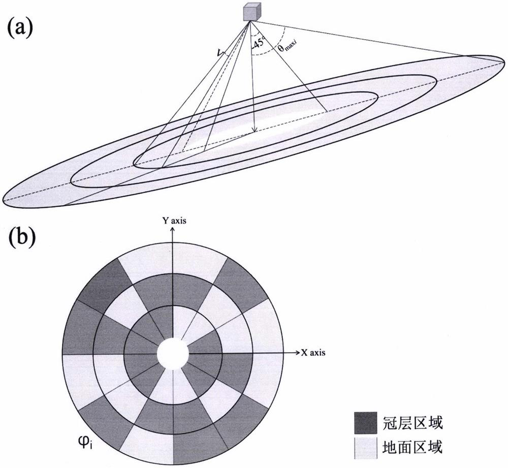
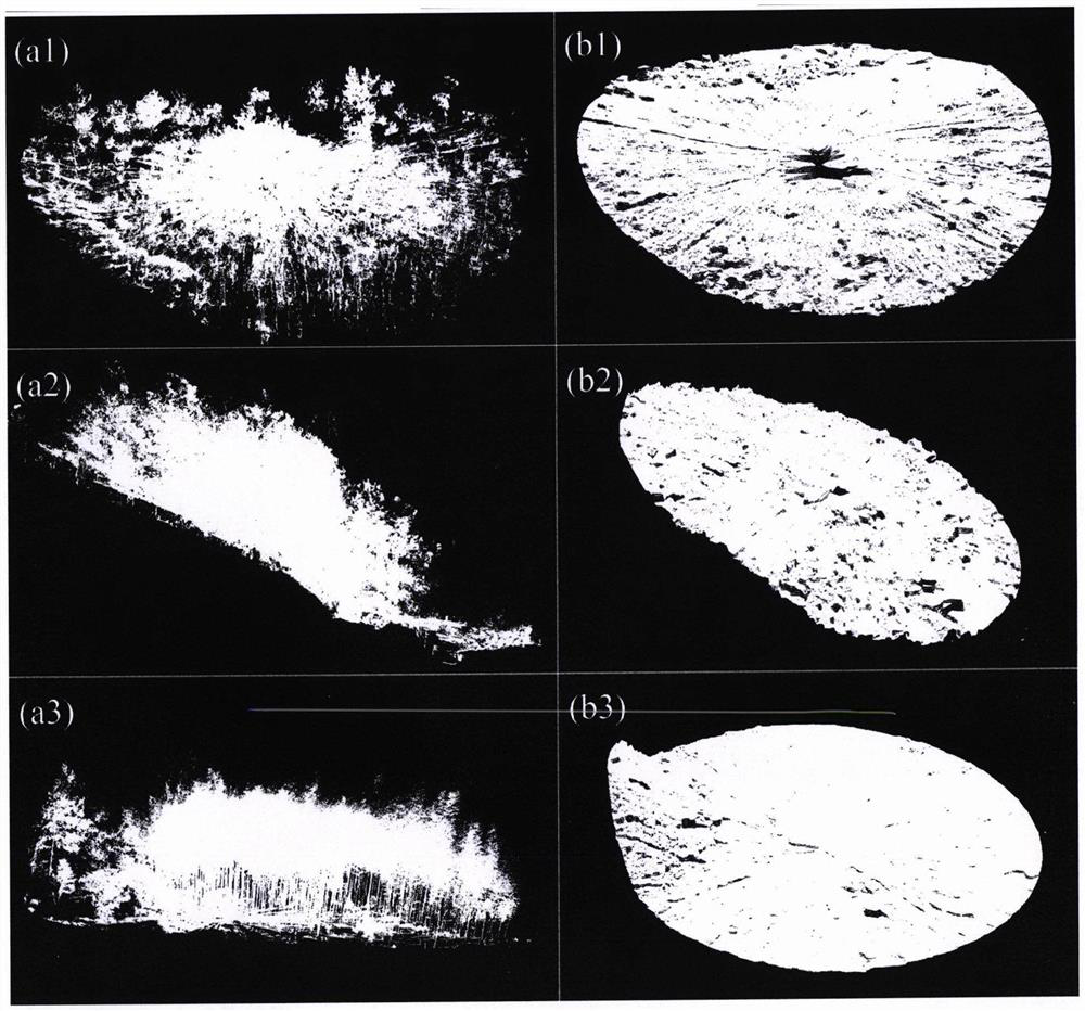
[0025] Use the ground lidar scanner to obtain forest quadrat TLS data under different complex terrain conditions according to the technical solution step (1) ( figure 2 a1-2a3). The sampling interval of TLS data is 1cm at 30m. After data acquisition, crop the central area of ​​the quadrat. Manually remove noise points from the data.

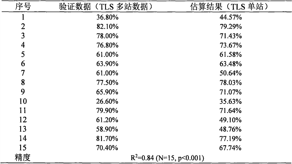
[0026] Obtain the ground point ( figure 2 b1-2b3). Then calculate the understory vegetation of each quadrat according to steps (4), (5) and (6) of the technical scheme. Based on the results of the TLS data obtained by the multi-station model, 15 forest quadrats with different terrain conditions, tree species, and canopy density were selected to verify the accuracy of the TLS data obtained by the single-station model in estimating the understory vegetation coverage (Table 1). .

[0027] Table 1 Comparison of understory vegetation coverage extracted based ...


PUM


Abstract

The invention provides a method for extracting under-forest vegetation coverage under a complex terrain condition by using ground laser radar data, belongs to the research field of a vegetation remote sensing inversion parameter method, and aims to solve the problem that the under-forest vegetation coverage cannot be rapidly and effectively extracted under the complex terrain condition at present. According to the method, a ground point is extracted via height information, and on the basis of the ground point, the coverage of the vegetation under the forest is estimated by using a directional slicing method. The method can be used to accurately extract the coverage of the vegetation under the forest under the complex terrain condition, is high in precision, and is has great significance in recognition of erosion of soil under the forest and research of forest carbon cycle.

Description

[0001] 1. Technical field [0002] The present invention is a method for extracting understory vegetation coverage under complex terrain conditions through ground laser radar data. Specifically, it refers to a method for obtaining forest canopy three-dimensional point cloud data through ground laser radar single-station mode, and accurately estimating complex terrain conditions The method for understory vegetation coverage belongs to the research field of vegetation remote sensing retrieval parameter method. [0003] 2. Background technology [0004] Understory vegetation refers to the vegetation in the forest whose height is less than a certain threshold (eg, 1.5, 2 meters). In tropical and subtropical regions, due to the obvious relief of terrain, frequent rainfall, soil parent material and human disturbance, the problem of soil erosion is more prominent. The understory vegetation is of great significance to prevent soil erosion. At the same time, understory vegetation is o...

Claims


Application Information

Patent Timeline
Patent Type & Authority Applications(China)
IPC IPC(8): G01S17/88G01S7/48
CPCG01S17/88G01S7/4802
Inventor 马利霞于东升冯凯月
Owner INST OF SOIL SCI CHINESE ACAD OF SCI
Why Eureka
Try Eureka