Ocean station water level space-time prediction method and device based on deep learning

A technology of deep learning and prediction methods, applied in the field of marine science and technology, can solve problems such as simple structure and single type

Pending Publication Date: 2021-05-28
NAT MARINE DATA & INFORMATION SERVICE
View PDF5 Cites 5 Cited by
  • Summary
  • Abstract
  • Description
  • Claims
  • Application Information

AI Technical Summary

Problems solved by technology

Another prediction method is to use machine learning to learn the law of water level changes, so as to predict the water level. The BP neural network model is commonly used, but most of the existing neural network models have simple structures and single types, which have great limitations.

Method used


Image

  • Ocean station water level space-time prediction method and device based on deep learning
  • Ocean station water level space-time prediction method and device based on deep learning
  • Ocean station water level space-time prediction method and device based on deep learning

Examples


Embodiment 1

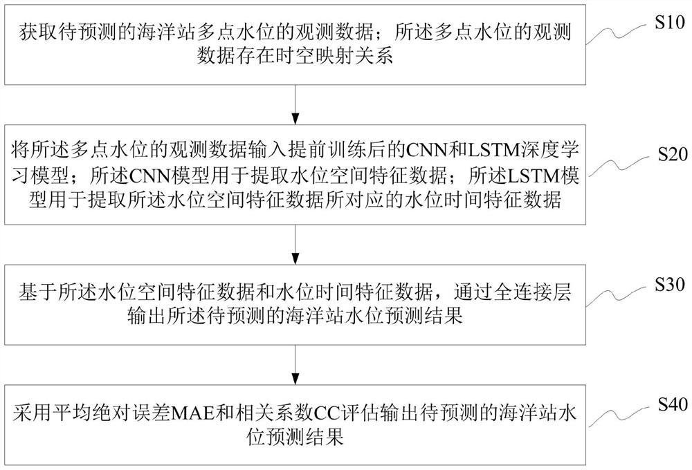
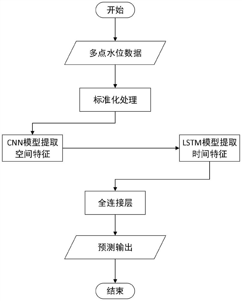
[0050] refer tofigure 1 As shown, the deep learning-based spatio-temporal prediction method of ocean station water level provided by the embodiment of the present invention can be executed in a mobile terminal, a computer terminal or a similar computing device; including:

[0051] S10. Obtain the observation data of multi-point water levels of ocean stations to be predicted; the observation data of multi-point water levels has a time-space mapping relationship;

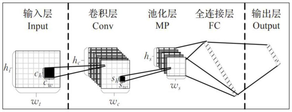
[0052] S20. Input the observation data of the multi-point water level into the pre-trained CNN and LSTM deep learning models; the CNN model is used to extract water level spatial feature data; the LSTM model is used to extract the water level corresponding to the spatial feature data The time characteristic data of the water level;

[0053] S30. Based on the water level spatial feature data and water level time feature data, output the to-be-predicted marine station water level prediction result through a fully connec...

Embodiment 2

[0096] The embodiment of the present invention also provides a deep learning-based water level spatio-temporal prediction device for marine stations, which can be used to implement the embodiment of the method disclosed in the above-mentioned embodiment 1, refer to Figure 5 shown, including:

[0097] The obtaining module 51 is used to obtain the observation data of the multi-point water level of the ocean station to be predicted; the observation data of the multi-point water level has a time-space mapping relationship;

[0098] Input module 52, for the observation data input of described multi-point water level CNN and LSTM deep learning model after training in advance; Described CNN model is used for extracting water level space characteristic data; Described LSTM model is used for extracting described water level space Water level time characteristic data corresponding to the characteristic data;

[0099] The prediction module 53 is configured to output the prediction resu...

Embodiment 3

[0108] The embodiment of the present invention further provides a deep learning-based water level space-time prediction device for marine stations, including: a processor; a memory for storing processor-executable instructions;

[0109] Wherein, the processor is configured as:

[0110] Obtain the observation data of the multi-point water level of the ocean station to be predicted; the observation data of the multi-point water level has a time-space mapping relationship;

[0111] The observation data of the multi-point water level is input into the CNN and LSTM deep learning model trained in advance; the CNN model is used to extract the water level spatial characteristic data; the LSTM model is used to extract the water level corresponding to the water level spatial characteristic data time characteristic data;

[0112] Based on the water level spatial feature data and water level time feature data, the predicted result of the ocean station water level to be predicted is outpu...


PUM


Abstract

The invention discloses an ocean station water level space-time prediction method and device based on deep learning. The method comprises the steps: acquiring observation data of multiple points of water levels of an ocean station to be predicted, wherein the observation data of the multi-point water level has a space-time mapping relation; inputting observation data of multi-point water levels into the CNN and LSTM deep learning model trained in advance, wherein the CNN model is used for extracting water level spatial feature data, and the LSTM model is used for extracting water level time characteristic data corresponding to the water level space characteristic data; and based on the water level spatial feature data and the water level time feature data, outputting a water level prediction result of the to-be-predicted ocean station through a full connection layer. According to the method, high-precision forecasting of ocean station water level data can be realized; only water level sequence data of a plurality of ocean stations are needed, and other data are not needed; occupied resources are few, and the calculation speed is high. And the method can be used for but not limited to ocean station water level forecasting, and can also be used for forecasting other elements except the water level element.

Description

technical field [0001] The invention relates to the technical field of marine science and technology, in particular to a deep learning-based spatiotemporal water level prediction method and device for marine stations. Background technique [0002] Water level is one of the most important components of the marine environment. Water level prediction is of great significance in the fields of marine transportation, disaster prevention and mitigation, ecological protection and energy utilization. The most commonly used water level prediction method is the harmonic analysis method. This method uses the Fourier series to expand the measured water level data, and separates the astronomical tide part of the water level from each tidal tide, so as to realize the astronomical tide through the prediction of the tidal equinox. Forecasting, since most of the water level signals are composed of astronomical tide signals, the prediction of astronomical tides can basically be equal to the p...

Claims


Application Information

Patent Timeline
Patent Type & Authority Applications(China)
IPC IPC(8): G06Q10/04G06N3/04G06N3/08G06F17/18
CPCG06Q10/04G06N3/08G06F17/18G06N3/045
Inventor 苗庆生韦广昊余璇何晓玉杨扬李维禄韩春花刘玉龙
Owner NAT MARINE DATA & INFORMATION SERVICE
Why Eureka
Try Eureka