
Train positioning system and method combining instant positioning and map construction

A technology for train positioning and map construction, applied in the field of rail transit, can solve the problems that GPS is difficult to provide accurate positioning, high reliability of beacon positioning, difficult construction and maintenance, etc., and achieves low follow-up maintenance costs and train positioning accuracy. Improved, high reliability effects

Active Publication Date: 2021-06-18
浙江众合科技股份有限公司
View PDF6 Cites 2 Cited by
  • Summary
  • Abstract
  • Description
  • Claims
  • Application Information

AI Technical Summary

Problems solved by technology

[0003] For the existing rail transit lines that use beacons to locate, to further improve the positioning accuracy, it is necessary to increase the number of beacons or even re-lay beacons, the cost of transformation is high and the construction and maintenance is difficult; while the GPS and inertial sensor combination positioning method does not require a huge amount of construction, but it has certain limitations. For example, it is difficult for GPS to provide accurate positioning in a tunnel environment. Accumulated errors lead to low positioning accuracy, and the positioning error may be plus or minus 5 meters or even lower, which means that positioning using GPS and inertial sensors is not as reliable as positioning with beacons

Method used


Image

  • Train positioning system and method combining instant positioning and map construction
  • Train positioning system and method combining instant positioning and map construction

Examples


Embodiment 1

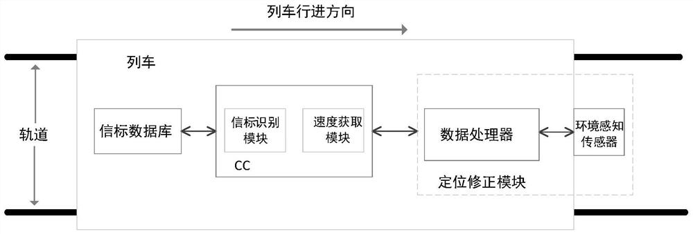
[0031] Such as figure 1 As shown, a train positioning system includes:

[0032] Beacon database: save the mileage data corresponding to all beacon serial numbers, and access the beacon database to obtain the mileage corresponding to the beacon and the positioning position of the train section.

[0033] On-board controller: including a beacon identification module and a speed acquisition module. The beacon identification module can identify the beacon installed on the track and obtain the serial number of the current beacon. The speed acquisition module can obtain the real-time speed of the current train.

[0034] Position correction module: including environment perception sensors and on-board data processors installed on the front of the train. The environmental perception sensor can obtain the environmental information in the direction of the train running, including the rail surface in front of the front of the vehicle, the tunnel wall, trackside equipment and other charac...

Embodiment 2

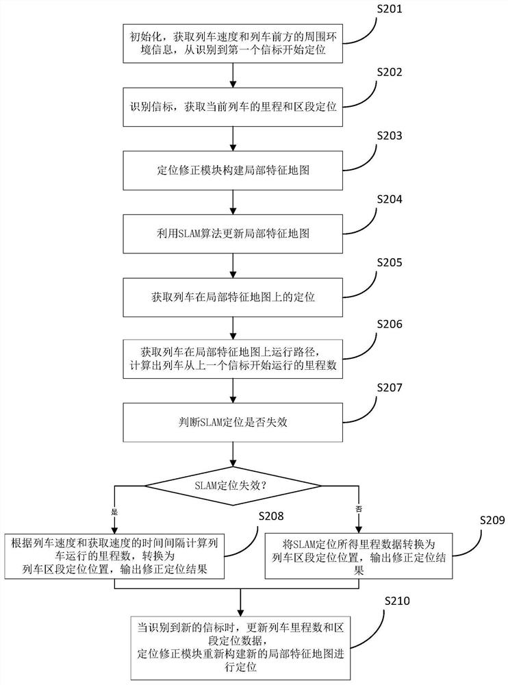
[0038] Such as figure 2 Shown, a kind of train location method, specific implementation comprises the steps:

[0039] S201: The speed acquisition module of the on-board controller continuously acquires the current speed of the train and sends it to the positioning correction module; the environment perception sensor in the positioning correction module acquires the surrounding environment information in front of the train, and the surrounding environment information acquired in this embodiment is the front of the train. Laser point cloud ahead; localization starts from the first beacon identified.

[0040] S202: When the beacon identification module of the on-board controller recognizes a beacon, query the beacon database according to the identified beacon serial number to obtain the mileage and section location of the current train (the section location here is based on the beacon location The result obtained), and send the data to the positioning correction module.

[004...


PUM


Abstract

The invention discloses a train positioning system combining instant positioning and map construction. The train positioning system comprises a beacon database, a vehicle-mounted controller and a positioning correction module, wherein beacon data is stored in the beacon database; the vehicle-mounted controller is provided with a beacon recognition module and a speed acquisition module, and train mileage data, train section positioning information and train real-time speed are sent to the positioning correction module; and the positioning correction module comprises an environment sensing sensor and a vehicle-mounted data processor, and the vehicle-mounted data processor obtains the position of the train through the SLAM technology according to the environment information and achieves positioning correction in combination with data provided by the vehicle-mounted controller. The invention further provides a train positioning method, and the train positioning system is adopted for positioning. According to the method, the train positioning precision is improved, positioning is carried out without depending on satellite signals, the application scene is wide, meanwhile, new beacons and trackside equipment do not need to be added, and the maintenance cost is low.

Description

technical field [0001] The invention belongs to the technical field of rail transit, and in particular relates to a train positioning technology. Background technique [0002] In the field of rail transit technology, the positioning data of the train is required. The traditional train positioning technology obtains the current position information of the train through beacons installed on the track or through the combination of GPS and inertial sensors, while the current mainstream method is to locate trains through passive or active beacons. [0003] For the existing rail transit lines that use beacon positioning, if you want to further improve the positioning accuracy, you need to increase the number of beacons or even re-lay beacons. There is no need to add a huge amount of construction, but it has certain limitations. For example, it is difficult for GPS to provide accurate positioning in a tunnel environment. The cumulative error caused by the characteristics of the in...

Claims


Application Information

Patent Timeline
IPC IPC(8): B61L25/02
CPCB61L25/021B61L25/026B61L25/028
Inventor 沈汪晴田巍胡明舟
Owner 浙江众合科技股份有限公司
Learn More