Geographic information acquisition device for territorial space planning

A technology of spatial planning and geographic information, applied in image communication, television, supporting machines, etc., can solve the problems of poor device stability, easy damage, and unstable device.

Active Publication Date: 2021-06-18
于少康
View PDF22 Cites 4 Cited by
  • Summary
  • Abstract
  • Description
  • Claims
  • Application Information

AI Technical Summary

Problems solved by technology

[0004] The purpose of the present invention is to solve the following shortcomings in the prior art. The existing information collection device is not stable due to the unevenness of the soil outdoors, so that the collection work of the device cannot be carried out well, and it is easy to cause discomfort to the staff , most of the existing information collection devices have poor mobility, which makes the device inconvenient to carry. loose state, which is prone to damage, and a geographic information collection device for land space planning is proposed

Method used


Image

  • Geographic information acquisition device for territorial space planning
  • Geographic information acquisition device for territorial space planning
  • Geographic information acquisition device for territorial space planning

Examples


Embodiment Construction

[0024] The following will clearly and completely describe the technical solutions in the embodiments of the present invention with reference to the accompanying drawings in the embodiments of the present invention. Obviously, the described embodiments are only some, not all, embodiments of the present invention.

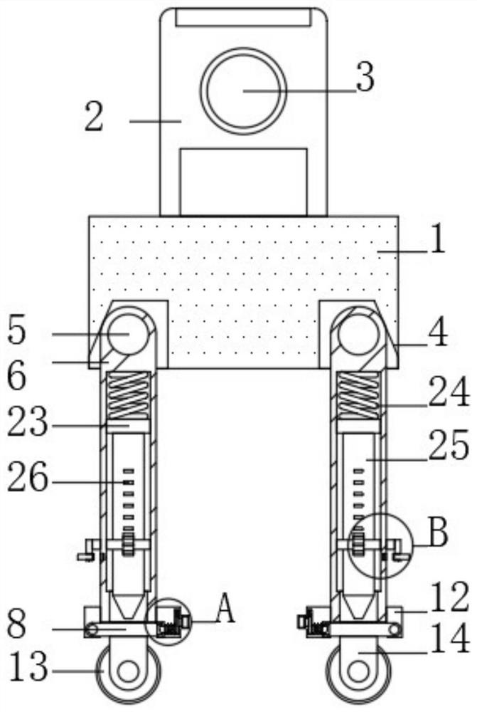
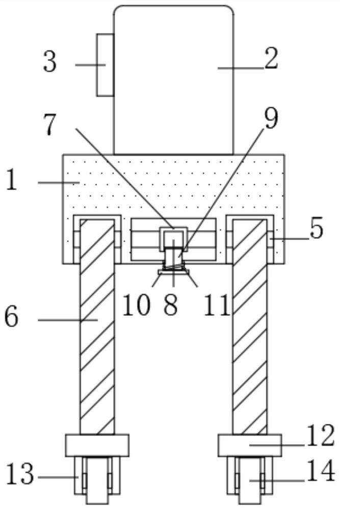
[0025] refer to Figure 1-4 A geographical information collection device for land space planning, comprising a base 1 and a device body 2, the device body 2 is fixedly connected to the upper side of the base 1, the device body 2 is provided with a camera 3, and the lower side of the base 1 is symmetrically provided with four A mounting groove 4, the inner side of the base 1 is rotationally connected with two first rotating shafts 5, both ends of the two first rotating shafts 5 pass through the inner side of the base 1, and extend into the mounting groove 4, each mounting groove 4 Outriggers 6 are fixedly connected to the first rotating shaft 5;

[0026] The inner si...


PUM


Abstract

The invention discloses a geographic information acquisition device for territorial space planning. The device comprises a base and an equipment body, wherein the equipment body is fixedly connected to the upper side of the base, a camera is arranged on the equipment body, four mounting grooves are symmetrically formed in the lower side of the base, two first rotating shafts are rotatably connected to the inner side of the base, the two ends of the two first rotating shafts penetrate through the inner side of the base and extend into the mounting grooves, the first rotating shaft in each mounting groove is fixedly connected with a supporting leg, two fixing assemblies used for limiting the first rotating shafts are arranged on the inner side of the base, and a displacement assembly is arranged on the lower side of each supporting leg. The design is reasonable, an adjusting assembly is arranged, a grip is rotated, the grip drives a gear to rotate through a connecting rod and a second rotating shaft, the gear rotates to drive the supporting legs to move up and down, and therefore the purpose of adjusting the extension length of the supporting legs is achieved, and the device can adapt to uneven land conveniently.

Description

technical field [0001] The invention relates to the technical field of geographic information collection, in particular to a geographic information collection device for land space planning. Background technique [0002] The geographic information collection device is a device used to measure and record the geographical information of some regions. The relevant information of the current region can be obtained through the geographic information collection device, and statistical processing can be performed to assist follow-up work. [0003] Due to the unevenness of the soil, the existing information collection device is not stable outdoors, which leads to the inability to carry out the collection work of the device well and easily causes discomfort to the staff. Most of the existing information collection devices have poor mobility. As a result, the device is inconvenient to carry. If a pulley is provided, the stability of the device is not good, which is not suitable for ex...

Claims


Application Information

Patent Timeline
Patent Type & Authority Applications(China)
IPC IPC(8): F16M11/32F16M11/34F16M11/36F16M11/42H04N5/225
CPCF16M11/32F16M11/34F16M11/36F16M11/42F16M2200/024F16M2200/048H04N23/50Y02E10/50
Inventor 于少康但承龙汪浩肖长江
Owner 于少康
Why Eureka
Try Eureka