Control platform of unmanned aerial vehicle surveying and mapping device

A technology for surveying and mapping devices and control platforms, which is applied in the field of drone surveying and mapping, and can solve problems such as inability to be directly applied, inability of drones to cruise accurately, and deviation of surveying and mapping data

Active Publication Date: 2021-07-06
YELLOW RIVER CONSERVANCY TECHN INST
View PDF6 Cites 3 Cited by
  • Summary
  • Abstract
  • Description
  • Claims
  • Application Information

AI Technical Summary

Problems solved by technology

[0005] The purpose of the present invention is to provide a control platform for a UAV surveying and mapping device, which solves the surveying and mapping of various complex terrains. The UAV cannot cruise accurately, and the surveying and mapping data will have a large deviation, resulting in inaccurate measurement data and cannot directly applied technical issues

Method used


Image

  • Control platform of unmanned aerial vehicle surveying and mapping device
  • Control platform of unmanned aerial vehicle surveying and mapping device
  • Control platform of unmanned aerial vehicle surveying and mapping device

Examples


Embodiment Construction

[0025] The technical solutions of the present invention will be clearly and completely described below in conjunction with the embodiments. Apparently, the described embodiments are only some of the embodiments of the present invention, not all of them. Based on the embodiments of the present invention, all other embodiments obtained by persons of ordinary skill in the art without creative efforts fall within the protection scope of the present invention.

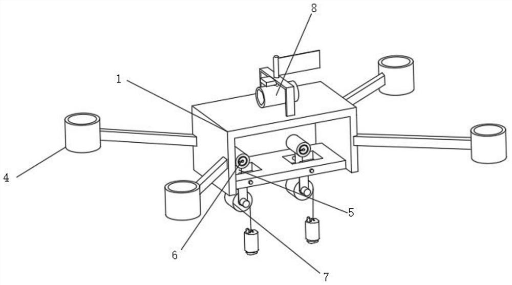
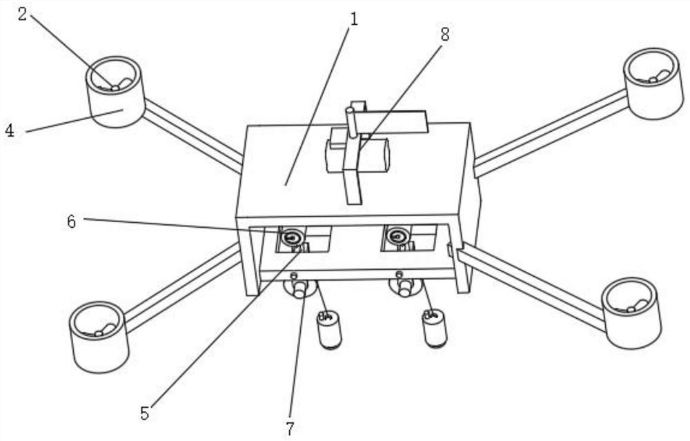
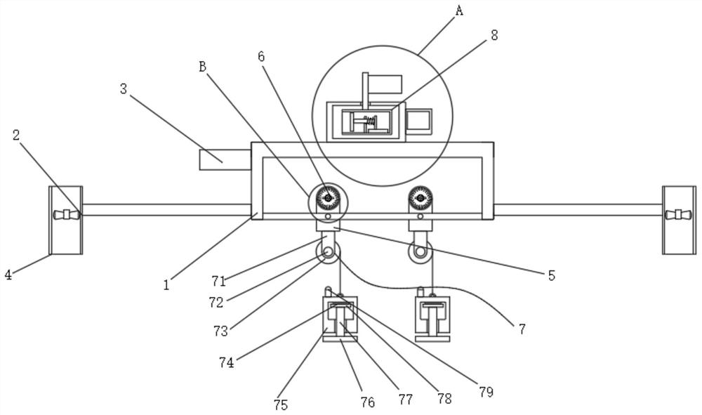
[0026] Such as Figure 1-5 As shown, a control platform of a UAV surveying and mapping device, including: a fuselage 1, a fan 2, a control box 3, an air duct 4, a swing rod 5, an angle monitoring structure 6, a distance monitoring structure 7 and a wind force monitoring structure 8 , four wind guide tubes 4 are installed in a circular array around the fuselage 1, fans 2 are installed inside the air guide tube 4, the control box 3 is installed on the top side wall of the fuselage 1, and the swing rod 5 is matched by a pin I...


PUM


Abstract

The invention discloses a control platform of an unmanned aerial vehicle surveying and mapping device, which comprises a machine body, fans, a control box, air ducts, swing rods, an angle monitoring structure, a spacing monitoring structure and a wind power monitoring structure, and is characterized in that the four air ducts are mounted on the periphery of the machine body in an annular array, and the fans are mounted in the air ducts; a lead block is placed at a measurement starting point, after the lead block is released, under the pushing cooperation of a linkage rod, contact of two conductive plates is achieved, after contact, an indicating lamp flashes, calibration of the starting point is achieved, at the end of measurement, the measurement distance can be judged more accurately through the flashing state of the indicating lamp, one end of a pointer walks along the inner wall of a trigger electrode plate, the swing angle of the swing rod can be measured, on-site surveying and mapping can be accurately carried out according to the length of a silk thread and the swing angle of the swing rod, meanwhile, different altitude intervals can be accurately measured, the accuracy is better, the operation is more convenient, and the device can be suitable for surveying and mapping of multiple terrains.

Description

technical field [0001] The invention relates to the technical field of unmanned aerial vehicle surveying and mapping, in particular to a control platform of an unmanned aerial vehicle surveying and mapping device. Background technique [0002] Surveying and mapping is literally understood as surveying and drawing. It is based on computer technology, photoelectric technology, network communication technology, space science, and information science. It is based on global navigation satellite positioning system (GNSS), remote sensing (RS), and geographic information system (GIS). The core of the technology is to select the existing feature points and boundaries on the ground and obtain the graphics and position information reflecting the current situation of the ground through measurement means for engineering construction, planning and design and administrative management; [0003] Unmanned aircraft, referred to as "UAV", is an unmanned aircraft controlled by radio remote cont...

Claims


Application Information

Patent Timeline
Patent Type & Authority Applications(China)
IPC IPC(8): B64C39/02B64D47/00G01P5/08G01C5/00
CPCB64C39/02B64D47/00G01P5/08G01C5/00B64U2101/00
Inventor 张丹王懿胡泊张辉唐红梅
Owner YELLOW RIVER CONSERVANCY TECHN INST
Why Eureka
Try Eureka