Sea-air rotation modulation inertial navigation/astronomical integrated navigation method
A technology of rotation modulation and integrated navigation, applied in the field of navigation, can solve problems such as filtering instability, achieve the effect of improving navigation accuracy and realizing fully autonomous navigation and positioning
- Summary
- Abstract
- Description
- Claims
- Application Information
AI Technical Summary
Problems solved by technology
Method used
Image

Examples
Embodiment Construction
[0112] The present invention will be described in further detail below in conjunction with the accompanying drawings and specific embodiments.
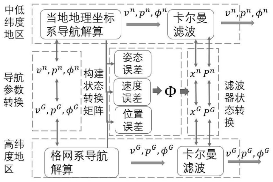
[0113] Such as figure 1 As shown, a sea-air rotation modulation inertial navigation / astronomical integrated navigation method includes the following steps:
[0114] (1) Determine the navigation coordinate system and position representation mode of large ships and large aircraft in high latitude navigation areas, including the following steps:
[0115] (1.1) Determine the navigation coordinate system for large ships and large aircraft when navigating in high-latitude areas. The navigation coordinate system in high-latitude areas is determined as a grid coordinate system, where the grid coordinate system is defined as: the grid plane is parallel to the Greenwich meridian plane, The intersection line between it and the tangent plane at the position of the large ship and large aircraft is the north direction of the grid, and the angle be...
PUM
 Abstract
Description
Claims
Application Information
 - R&D
- Intellectual Property
- Life Sciences
- Materials
- Tech Scout
- Unparalleled Data Quality
- Higher Quality Content
- 60% Fewer Hallucinations
Browse by: Latest US Patents, China's latest patents, Technical Efficacy Thesaurus, Application Domain, Technology Topic, Popular Technical Reports.
© 2025 PatSnap. All rights reserved.Legal|Privacy policy|Modern Slavery Act Transparency Statement|Sitemap|About US| Contact US: help@patsnap.com