
Coastline remote sensing extraction method

An extraction method, coastline technology, applied in image data processing, instrument, character and pattern recognition, etc., can solve problems such as inability to use coastline changes, fine analysis, etc.

Active Publication Date: 2021-08-06
GUANGZHOU INST OF GEOGRAPHY GUANGDONG ACAD OF SCI +1
View PDF7 Cites 2 Cited by
  • Summary
  • Abstract
  • Description
  • Claims
  • Application Information

AI Technical Summary

Problems solved by technology

At present, common remote sensing pixel-scale automatic coastline extraction methods such as edge detection, threshold segmentation, object-oriented methods, artificial intelligence detection and other methods can extract coastlines from medium-resolution images with the same spatial resolution as the original images. For fine-grained analysis of coastline changes

Method used


Image

  • Coastline remote sensing extraction method
  • Coastline remote sensing extraction method
  • Coastline remote sensing extraction method

Examples


Embodiment Construction

[0057] The following will clearly and completely describe the technical solutions in the embodiments of the present invention with reference to the accompanying drawings in the embodiments of the present invention. Obviously, the described embodiments are only some, not all, embodiments of the present invention. Based on the embodiments of the present invention, all other embodiments obtained by persons of ordinary skill in the art without making creative efforts belong to the protection scope of the present invention.

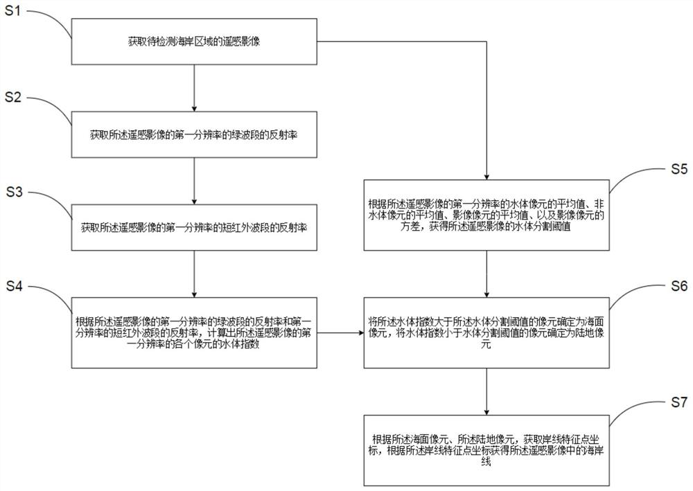
[0058] see figure 1 , which is a flow chart of a coastline remote sensing extraction method according to an embodiment of the present invention, comprising the following steps:

[0059] S1: Obtain remote sensing images of the coastal area to be detected;

[0060] The remote sensing images refer to films or photos that record the size of electromagnetic waves of various ground features, and are mainly divided into aerial photos and satellite photos. By perfor...


PUM


Abstract

The invention provides a coastline remote sensing extraction method. The method comprises the following steps: acquiring a remote sensing image of a to-be-detected coastline area; according to the reflectivity of the green band of the first resolution of the remote sensing image and the reflectivity of the short infrared band of the first resolution of the remote sensing image, calculating a water body index of each pixel of the first resolution of the remote sensing image; obtaining a water body segmentation threshold value of the remote sensing image according to the average value of the water body pixels, the average value of the non-water body pixels, the average value of the image pixels and the variance of the image pixels of the first resolution of the remote sensing image; determining the pixels of which the water body indexes are greater than the water body segmentation threshold value as sea surface pixels, and determining the pixels of which the water body indexes are smaller than the water body segmentation threshold value as land pixels; and according to the sea surface pixel and the land pixel, obtaining a coastline feature point coordinate, and according to the coastline feature point coordinate, obtaining a coastline in the remote sensing image. According to the method, the spatial resolution and the position precision of the coastline extracted from the remote sensing image can be improved.

Description

technical field [0001] The invention relates to the technical field of geographic information detection, in particular to a coastline remote sensing extraction method. Background technique [0002] Remote sensing survey and monitoring has become an effective technical means for large-scale coastline extraction and change research. At present, common remote sensing pixel-scale automatic coastline extraction methods such as edge detection, threshold segmentation, object-oriented methods, artificial intelligence detection and other methods can extract coastlines from medium-resolution images with the same spatial resolution as the original images. For fine-grained analysis of coastline changes. Contents of the invention [0003] The purpose of the present invention is to overcome the shortcomings and deficiencies in the prior art, and provide a coastline remote sensing extraction method that can improve the spatial resolution and position accuracy of the coastline extracted ...

Claims


Application Information

Patent Timeline
IPC IPC(8): G06K9/00G06K9/46G06T7/136
CPCG06T7/136G06T2207/10032G06T2207/30181G06V20/13G06V10/40
Inventor 胡泓达刘旭拢杨骥谢蕴文许剑辉邓应彬李勇
Owner GUANGZHOU INST OF GEOGRAPHY GUANGDONG ACAD OF SCI
Learn More