Shallow Sea Remote Sensing Water Depth Inversion Method Based on Fui Partition and Ransac

A water depth inversion and water depth technology, applied in complex mathematical operations, design optimization/simulation, special data processing applications, etc., can solve problems that affect the accuracy and efficiency of shallow sea multispectral remote sensing water depth inversion, and achieve good anti-gross performance , Improving the inversion accuracy and the effect of improving the accuracy

Active Publication Date: 2021-09-07
CHINA UNIV OF GEOSCIENCES (WUHAN)
View PDF5 Cites 0 Cited by
  • Summary
  • Abstract
  • Description
  • Claims
  • Application Information

AI Technical Summary

Problems solved by technology

The above difficulties have seriously affected the accuracy and efficiency of shallow sea multispectral remote sensing depth retrieval.

Method used


Image

  • Shallow Sea Remote Sensing Water Depth Inversion Method Based on Fui Partition and Ransac
  • Shallow Sea Remote Sensing Water Depth Inversion Method Based on Fui Partition and Ransac
  • Shallow Sea Remote Sensing Water Depth Inversion Method Based on Fui Partition and Ransac

Examples


Embodiment Construction

[0060] The principles and features of the present invention are described below in conjunction with the accompanying drawings, and the examples given are only used to explain the present invention, and are not intended to limit the scope of the present invention.

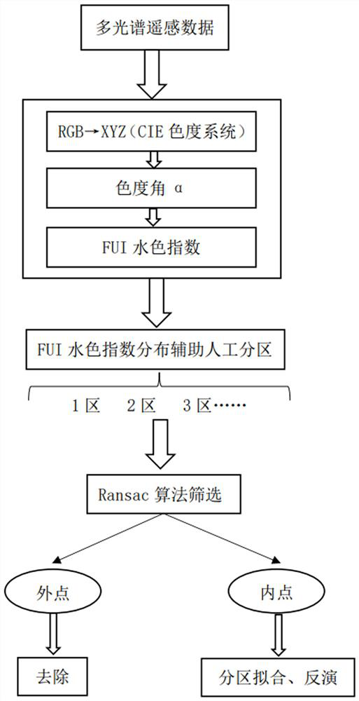
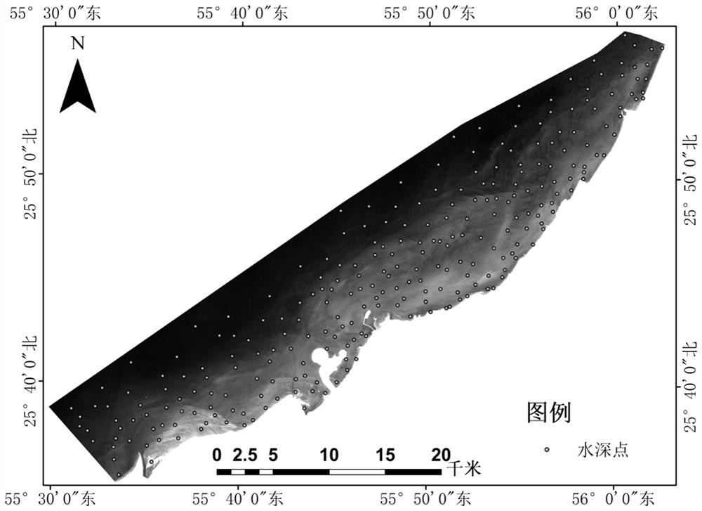
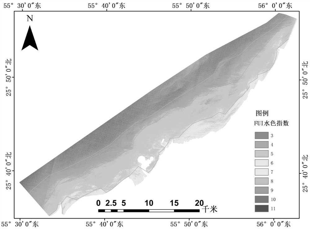
[0061] This invention proposes a shallow sea remote sensing water depth inversion method based on FUI partition and Ransac. For the complete technical route, see figure 1 and Figure 28 . The research area of ​​the embodiment of the present invention is the narrow and long shallow waters located in the northern half of Ras Al Khaimah in the Middle East, see figure 2 . This place guards the fortress entering and exiting the Persian Gulf and has a very important strategic position.

[0062] (S1) The Sentinel-2B multispectral data of the research area of ​​the embodiment of the present invention was obtained, see figure 2 , and preprocess it, including radiometric correction and atmospheric correction. Since the...


PUM


Abstract

The present invention relates to a shallow sea remote sensing water depth inversion method based on FUI partition and Ransac. The present invention first uses multi-spectral remote sensing data to calculate the FUI water color index, and based on the distribution of the FUI water color index, combined with manual visual interpretation, the shallow sea area Partition; then use the Ransac algorithm to filter the data set of field sounding points in each partition (the sounding value of the field sounding point and its corresponding reflectance on the R, G, and B bands), retain the correct data, and remove the existing Data with large errors; finally, use the preserved field sounding point data set for partition inversion. The invention organically combines the idea of ​​partitioning with the idea of ​​robust estimation, and improves the inversion precision to a certain extent. The invention can be widely applied to the field of shallow sea multispectral remote sensing water depth inversion.

Description

technical field [0001] The invention relates to the field of ocean remote sensing, in particular to a depth inversion method for shallow sea remote sensing based on FUI partition and Ransac. Background technique [0002] Water depth is one of the important geographical elements in shallow sea areas, and it is of great significance for the development and protection of coastal zones, maritime navigation, and marine scientific research. Remote sensing technology has the advantages of large scale, low cost, repeated observation, etc., which provides an effective new method for shallow sea depth detection. Due to the advantages of simple technical methods and relatively easy data acquisition, it is most common to use multispectral remote sensing data to invert water depth. However, there are two difficulties in using multispectral remote sensing data to retrieve shallow water depth. First, due to the complex environmental factors in shallow sea areas, a single semi-theoretical...

Claims


Application Information

Patent Timeline
Patent Type & Authority Patents(China)
IPC IPC(8): G06F30/20G06F17/10
CPCG06F17/10G06F30/20
Inventor 宋妍徐皓冉李贝贝
Owner CHINA UNIV OF GEOSCIENCES (WUHAN)
Why Eureka
Try Eureka