A land and water segmentation method for unsupervised domain adaptation of remote sensing images

A technology of remote sensing image, water and land segmentation

Active Publication Date: 2022-04-05
EAST CHINA NORMAL UNIV
View PDF0 Cites 0 Cited by
  • Summary
  • Abstract
  • Description
  • Claims
  • Application Information

AI Technical Summary

Problems solved by technology

However, there is a discrepancy between the training (source) and test (target) images

Method used


Image

  • A land and water segmentation method for unsupervised domain adaptation of remote sensing images
  • A land and water segmentation method for unsupervised domain adaptation of remote sensing images
  • A land and water segmentation method for unsupervised domain adaptation of remote sensing images

Examples


Embodiment 1

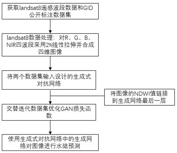
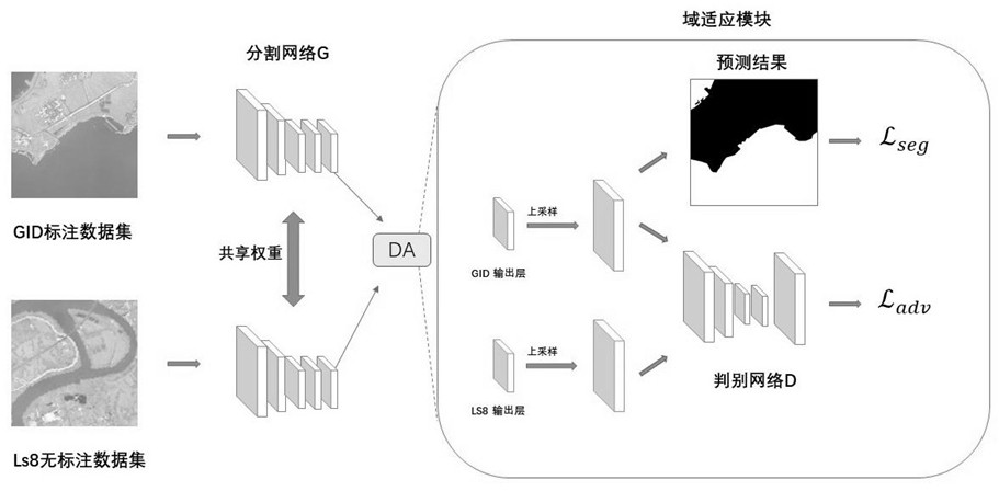
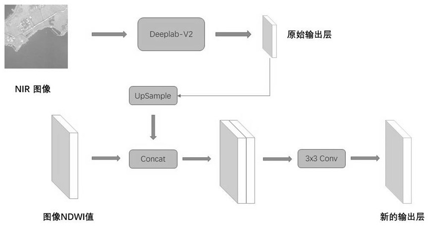
[0024] See attached figure 1 , the present invention uses the remote sensing band data formed by Landsat satellites to synthesize four-channel images through linear stretching, so that the image style is similar to that of the public labeled data set GID. Then, a generative confrontation training convolutional neural network is designed based on AdaptSegnet, and the supervised GID dataset and the unsupervised landsat8 dataset are mapped to the same feature space for segmentation. At the same time, the NDWI value of the image is linked to the feature space, and the detailed information of the image is preserved. During training, two data sets are alternately passed in. For the GID data set, the generation network G and the discriminant network D in the network model are optimized, and for the landsat8 data set, the discriminant network D in the network model is optimized. Finally, the input Landsat satellite remote sensing images can be output to predict the land and water seg...


PUM


Abstract

The invention discloses a water and land segmentation method for unsupervised domain adaptation of remote sensing images. Domain adaptation makes the model simple and fast for Landsat satellite remote sensing data. The specific implementation includes steps such as data acquisition, network design, and network training and output. Compared with the prior art, the invention can directly output the recognition result of land and water segmentation for the input Landsat satellite remote sensing data. Compared with the method of field measurement, the invention is simpler, and can directly use the public supervision data set to perform domain adaptation on the neural network. It avoids labeling its own data set, saving a lot of manpower and time.

Description

technical field [0001] The invention relates to the technical field of semantic segmentation of remote sensing images, in particular to an unsupervised domain adaptive land and water segmentation method based on Landsat satellite remote sensing images. Background technique [0002] Semantic segmentation of remote sensing images is the task of assigning a semantic label to each pixel, which is widely used in land use surveys and environmental monitoring. Land and water segmentation plays an important role in coastline extraction and channel mid-dam observation. In recent years, supervised algorithms, especially deep convolutional neural networks (CNNs), have shown impressive performance in semantic segmentation of remote sensing images. Segmentation based on deep learning often requires a large amount of manually labeled data for training, and labeling remote sensing images for each pixel is time-consuming and laborious. [0003] Currently, one approach to this problem is t...

Claims


Application Information

Patent Timeline
Patent Type & Authority Patents(China)
IPC IPC(8): G06T7/10G06V10/25G06K9/62G06N3/04G06N3/08G06V10/764
CPCG06T7/10G06N3/08G06T2207/10032G06T2207/20004G06V10/25G06N3/045G06F18/241
Inventor 胡文心顾城龙楚琪戴志军
Owner EAST CHINA NORMAL UNIV
Why Eureka
Try Eureka