Coastal soil salinity assessment method and system

A soil and salinity technology, which is applied in the field of soil salinity hyperspectral estimation, can solve the problems of inapplicability, difficulty, and complexity of methods in the estimation of variability in soil salinity.

Pending Publication Date: 2021-08-24
SHANDONG NORMAL UNIV
View PDF3 Cites 0 Cited by
  • Summary
  • Abstract
  • Description
  • Claims
  • Application Information

AI Technical Summary

Problems solved by technology

However, for soils with high water variability, it is difficult to select classification gradients to achieve uniform distribution of samples in different water groups, and the method of class-by-class modeling is more complex
Therefore, estimation of salinity in variable soils in coastal saline regions is not applicable

Method used


Image

  • Coastal soil salinity assessment method and system
  • Coastal soil salinity assessment method and system
  • Coastal soil salinity assessment method and system

Examples


Embodiment 1

[0045] Embodiment 1 of the present invention provides a coastal soil salinity assessment system, the system comprising:

[0046] Determination module for preprocessing and spectral analysis of soil spectra to determine the quantitative relationship between moisture and salinity and soil hyperspectral;

[0047] The construction module is used for according to the quantitative relationship, utilizes segmental direct standardization PDS and orthogonal signal correction OSC, combines the partial least squares regression algorithm, constructs the estimation model of soil salinity and evaluates the estimation model accuracy before and after removing the moisture disturbance respectively, Optimizing the best salinity estimation model;

[0048] The analysis module is used to combine the soil salinity estimation model, use the Spearman correlation coefficient and the importance of variable projection to determine the important bands of coastal soil salinity estimation, and evaluate the...

Embodiment 2

[0068] In order to solve the estimation of coastal soil salinity under the background of water interference, this embodiment 2 provides a method and system for estimating coastal soil salinity by using visible-near infrared spectroscopy.

[0069] A method for estimating coastal soil salinity using visible-near-infrared spectroscopy includes the following steps:

[0070] Step A: Preprocessing and spectral analysis of the soil spectrum to determine the quantitative relationship between moisture and salinity and soil hyperspectrum;

[0071] Step B: Use Piecewise Direct Standardization (PDS) and Orthogonal Signal Correction (OSC) to process the spectra, and use the Partial Least Squares Regression (PLSR) modeling method to build a soil salinity estimation model and evaluate the removal of water Estimate model accuracy before and after interference, and optimize the best salinity estimation model;

[0072] Step C: Using Spearman's correlation coefficient (r) and variable projected...

Embodiment 3

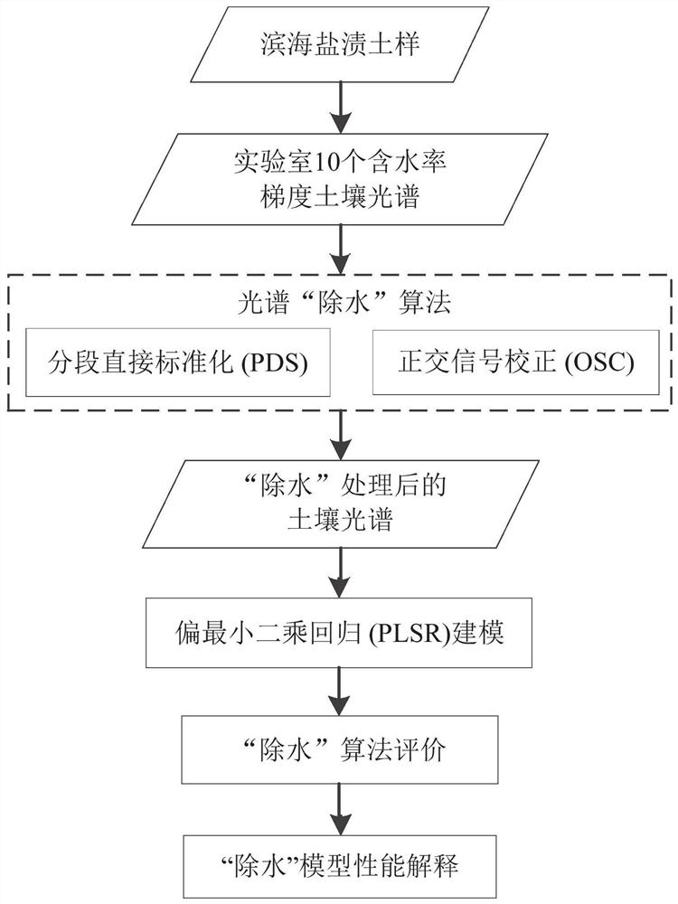
[0095] Such as figure 1 As shown, the present embodiment 3 provides a method for estimating coastal soil salinity using visible-near-infrared spectroscopy, including the following steps:

[0096] Step A: Preprocessing and spectral analysis of the soil spectrum to determine the quantitative relationship between moisture and salinity and soil hyperspectrum;

[0097] Step B: Preprocess the spectra using Piecewise Direct Standardization (PDS) and Orthogonal Signal Correction (OSC), respectively, and use the Partial Least Squares Regression (PLSR) modeling method to construct a soil salinity estimation model and evaluate the removal of Estimate model accuracy before and after water disturbance, and optimize the best salinity estimation model;

[0098] Step C: Using Spearman's correlation coefficient (r) and variable projected importance (VIP) to identify significant bands for coastal soil salinity estimation and explain model performance.

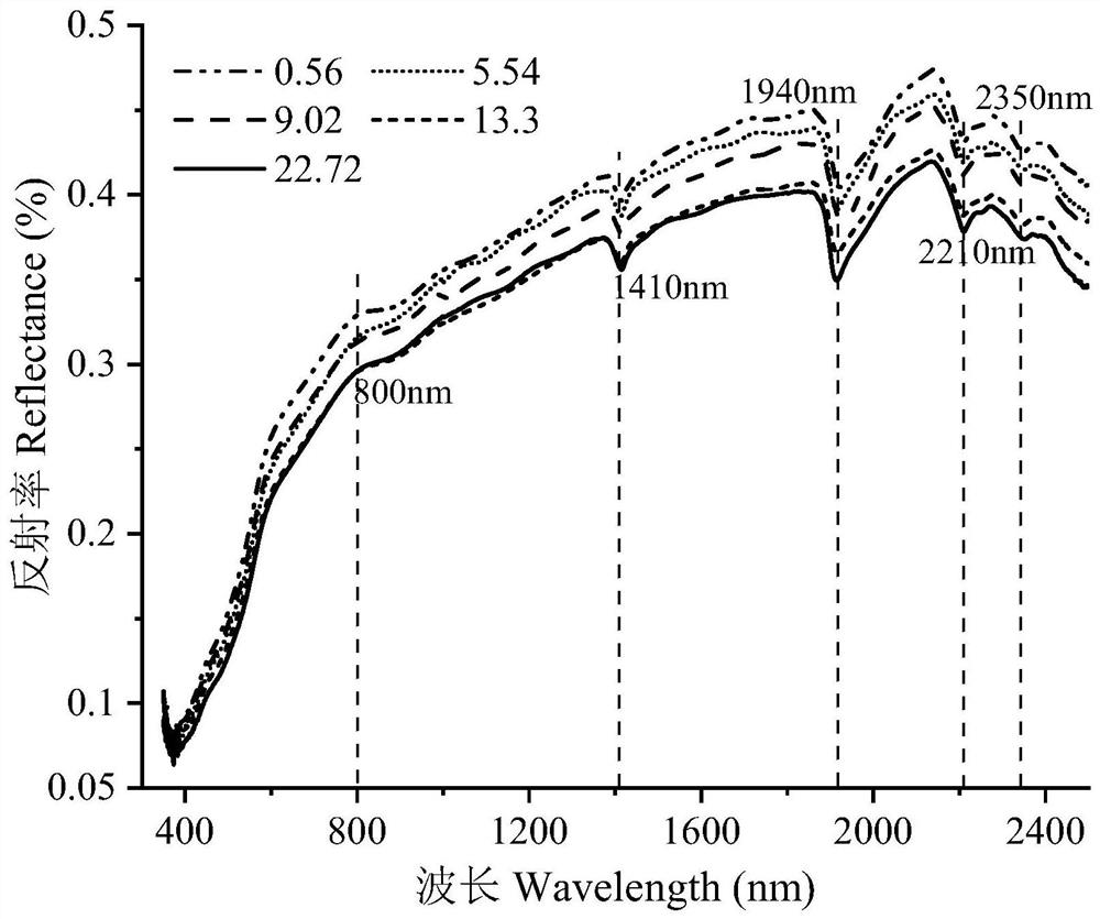
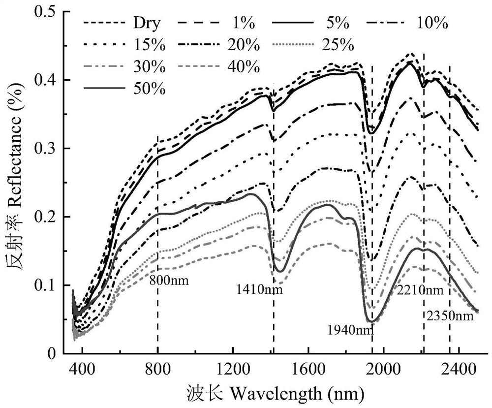
[0099] In this embodiment 3, 10 water c...


PUM


Abstract

The invention provides a coastal soil salinity evaluation method and system, and belongs to the technical field of soil salinity estimation. The method comprises the steps of determining the quantitative relation between moisture and soil hyperspectrum and between salinity and soil hyperspectrum, and constructing a soil salinity estimation model by utilizing segmented direct standardization PDS and orthogonal signal correction OSC and combining a partial least squares regression (PLSR) algorithm; and in combination with the soil salinity estimation model, determining an important wave band for coastal soil salinity estimation by utilizing a Spearman correlation coefficient and variable projection importance, and evaluating the soil salinity. According to the method, the quantitative relation between the moisture and the soil hyperspectrum and between the salinity and the soil hyperspectrum is determined, the interference of the moisture on the soil spectrum is eliminated, a soil salinity estimation model is constructed by combining a partial least squares regression (PLSR) modeling method, and the interference of the moisture is eliminated respectively; the important wave band of coastal soil salinity estimation is determined by using the Spearman correlation coefficient (r) and the variable projection importance (VIP), the model performance is evaluated, and accurate evaluation of the coastal soil salinity is realized.

Description

technical field [0001] The invention relates to the technical field of hyperspectral estimation of soil salinity, in particular to a method and system for evaluating coastal soil salinity using visible-near-infrared spectra. Background technique [0002] Part of the coastal mildly salinized soil can be transformed into cultivated land after remediation, and its improvement and remediation are of great significance to the protection of cultivated land. Visible-near-infrared spectroscopy is fast, non-destructive and cost-effective, and is widely used in soil salinity estimation and salinization monitoring. As an almost inevitable spectral interference factor, moisture has a nonlinear effect on soil reflectance, resulting in a decrease in reflectance. The high moisture content and high variability of soil moisture in coastal saline-alkali areas limit the research of saline soil spectra to a certain extent, and reduce the accuracy of quantitative estimation of soil salinity by ...

Claims


Application Information

Patent Timeline
IPC IPC(8): G06F30/20G16C20/20G01N21/25
CPCG06F30/20G16C20/20G01N21/25
Inventor 曹见飞杨晗吴泉源王召海
Owner SHANDONG NORMAL UNIV
Why Eureka
Try Eureka