Typhoon path identification method and device

A typhoon and path technology, applied in image data processing, instruments, calculations, etc., can solve the problems of low recognition accuracy and slow calculation speed, and achieve the effects of good robustness, high accuracy and good generality.

Pending Publication Date: 2021-08-27
CHINA ELECTRIC POWER RES INST +2
View PDF0 Cites 2 Cited by
  • Summary
  • Abstract
  • Description
  • Claims
  • Application Information

AI Technical Summary

Problems solved by technology

In the past, the methods of identifying typhoon center and track based on meteorological routine observation data were all calculated and identified based on the meteorological data itself. The calculation data is huge, and the calculation speed is usually slow and the identification accuracy is low.

Method used


Image

  • Typhoon path identification method and device
  • Typhoon path identification method and device
  • Typhoon path identification method and device

Examples


Embodiment 1

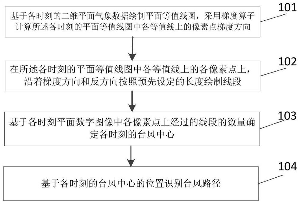
[0069] The present invention proposes an automatic identification method of a typhoon path, such as figure 1 As shown, the method includes:

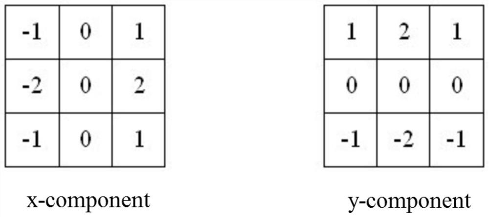
[0070] Step 101: Draw a plane contour map based on the two-dimensional plane meteorological data at each time, and use a gradient operator to calculate the gradient direction of the pixel point on each contour line in the plane contour map at each time;

[0071] Step 102: On each pixel point on each contour line in the plane contour map at each moment, draw a line segment along the gradient direction and the opposite direction according to a preset length;

[0072] Step 103: Determine the typhoon center at each moment based on the number of line segments passing through each pixel in the planar digital image at each moment;

[0073] Step 104: Identify the typhoon track based on the location of the typhoon center at each moment.

[0074] Step 101 specifically includes:

[0075] Based on the observed or forecasted two-dimensional planar...

Embodiment 2

[0101] The process of identifying the meteorological element map at a certain time is as follows:

[0102] 1) Draw a contour map and process it into a black and white binary image, such as Figure 4 shown;

[0103] 2) Calculate the pixel point gradient on the contour line, draw a line segment according to the gradient direction, and count the points passed by the line segment in the accumulative counter;

[0104] 3) Set the threshold, filter the points in the counter that are greater than the threshold, and find the local maximum at the same time, and determine it as the center of the typhoon, such as Figure 5 shown;

[0105] 4) According to the position of the typhoon center on the planar digital image, the longitude and latitude of the typhoon center are correspondingly obtained, and the judgment results of the data at each time are connected to generate a picture of the typhoon path.

Embodiment 3

[0107] The invention provides a typhoon path identification device, such as Figure 6 As shown, the device includes:

[0108] Calculation module, for drawing a plane contour map based on the two-dimensional plane meteorological data at each moment, using a gradient operator to calculate the gradient direction of the pixels on each contour line in the plane contour map at each moment;

[0109] The drawing module is used to draw a line segment along the gradient direction and the opposite direction according to a preset length on each pixel point on each contour line in the plane contour map at each moment;

[0110] A determining module, configured to determine the typhoon center at each moment based on the number of line segments passing through each pixel in the planar digital image at each moment;

[0111] The identification module is used to identify the typhoon track based on the position of the typhoon center at each moment.

[0112] The calculation module is specificall...


PUM


Abstract

The invention relates to a typhoon path identification method and device. The method comprises the steps: drawing a plane contour map based on two-dimensional plane meteorological data at each moment, and calculating the pixel gradient direction on each contour line in the plane contour map at each moment through a gradient operator; drawing a line segment on each pixel point on each contour line in the plane contour map at each moment along a gradient direction and a reverse direction according to a preset length; determining a typhoon center at each moment based on the number of line segments passing through each pixel point in the plane digital image at each moment; and identifying a typhoon path based on the position of the typhoon center at each moment. According to the invention, based on the drawn weather map, the typhoon center is identified by using an algorithm in the field of computer vision, a typhoon path is rapidly and accurately identified and image display is performed by processing a large amount of meteorological data, and the method can also be used in a disaster prevention system and other production element superposition display, and has the advantages of mature algorithm, high calculation speed, high recognition accuracy and the like.

Description

technical field [0001] The invention relates to the field of electric power meteorology, in particular to a typhoon path identification method and device. Background technique [0002] Tropical cyclone (TC) is one of the main disastrous weather systems affecting my country's coastal areas and some inland areas. It is formed on the tropical or subtropical ocean surface and has organized convection and definite cyclonic circulation. Collective term for sexual vortex. [0003] Typhoons often cause large-scale tripping of transmission and distribution lines, manifested as a large number of group faults, which may be transient faults or permanent faults, of which the proportion of the latter is relatively high. When the typhoon wind exceeds the design standard of the line or tower, it may cause line breakage and tower collapse accidents. At the same time, typhoons are often accompanied by heavy rains, which affect the foundation of towers, which may cause accidents of tower coll...

Claims


Application Information

Patent Timeline
Patent Type & Authority Applications(China)
IPC IPC(8): G01W1/00G06T7/00
CPCG01W1/00G06T7/0002G06T2207/30192
Inventor 刘晓琳冯双磊王勃靳双龙宋宗朋滑申冰孙晨蕾胡菊马振强王姝
Owner CHINA ELECTRIC POWER RES INST
Why Eureka
Try Eureka