Distance and course measurement method based on laser radar

A technology of laser radar and measurement method, applied in the field of environmental perception, which can solve the problems of sparse environmental texture features, dim light, and easy failure of positioning

Pending Publication Date: 2021-08-31
SHENYANG INST OF AUTOMATION - CHINESE ACAD OF SCI
View PDF0 Cites 4 Cited by
  • Summary
  • Abstract
  • Description
  • Claims
  • Application Information

AI Technical Summary

Problems solved by technology

In the long corridor environment, due to the dim light and sparse environmental texture features, the positioning method based ...

Method used


Image

  • Distance and course measurement method based on laser radar
  • Distance and course measurement method based on laser radar
  • Distance and course measurement method based on laser radar

Examples


Embodiment Construction

[0057]In order to make the above objects and features of the present invention more obvious and comprehensible, the specific implementation of the present invention will be described in detail below in conjunction with the accompanying drawings. Unless defined otherwise, technical and scientific terms used herein belong to the common understanding of those skilled in the art of the invention.

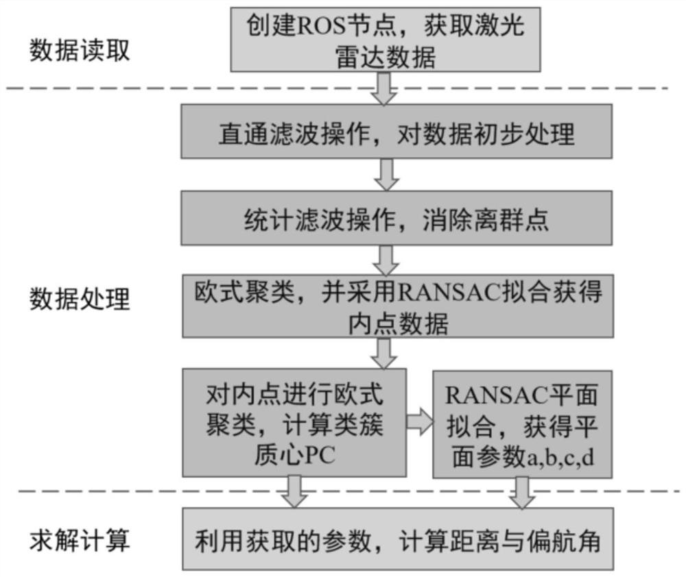
[0058] Such as figure 1 For the method flowchart of the present invention, the distance and heading measurement method based on laser radar includes the following specific processes:

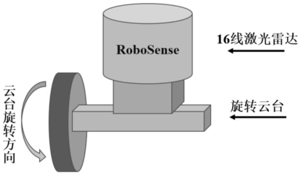
[0059] First, by controlling the rotation of the lidar pan / tilt, it is ensured that the lidar pan / tilt is in the same parallel plane as the robot body when scanning the environment. The lidar sensor model is as follows: figure 2 shown. The lidar uses RoboSense 16-line lidar, which measures 360 degrees horizontally and -15-15 degrees vertically. The laser radar and the industrial computer use Ethernet ...


PUM


Abstract

The invention relates to a distance and course measurement method based on a laser radar. According to the method, on the basis of 16-line laser radar, a distance between wall surfaces on the two sides of the robot in a long corridor environment and a yaw angle of the robot in the advancing direction are measured. The method comprises the following steps of 1) installing a laser radar sensor on a rotary holder of a robot, and scanning to obtain three-dimensional point cloud data of an environment; 2) extracting features required by measurement from the scanned three-dimensional point cloud data, wherein the specific operation comprises steps of performing straight-through filtering, statistical filtering, European clustering and random sampling consistency segmentation on the obtained three-dimensional point cloud, and calculating the centroid of the clustered point cloud cluster; and 3) according to the obtained centroid and plane parameters of the point cloud cluster, calculating a distance from the laser radar to the wall surfaces on the two sides of the corridor and the yaw angle of the robot. According to the method, requirements of the robot on the distance to the wall surfaces on the two sides and the yaw angle in autonomous navigation in the long corridor environment are met, and autonomous navigation of the robot in a specific scene is realized through provided data.

Description

technical field [0001] The present invention relates to the technical field of environment perception, in particular to the measurement of the distance between walls on both sides and the calculation of the yaw angle in a long corridor environment based on laser radar. Background technique [0002] As an active measurement sensor, lidar can accurately obtain the depth information of the scene, and has good anti-interference ability. It has great application value in the fields of robot navigation and engineering survey. In the long corridor environment, due to dim light and sparse environmental texture features, positioning methods based on vision or laser cannot extract effective environmental feature information, and positioning is prone to failure or large drift. [0003] Aiming at these environmental conditions, a lightweight distance and yaw angle measurement method is proposed to ensure the autonomous navigation of the robot by providing the distance from the robot to ...

Claims


Application Information

Patent Timeline
IPC IPC(8): G01S17/08G01S17/931G01S7/48
CPCG01S17/08G01S17/931G01S7/4802
Inventor 卜春光张建刚范晓亮赵忆文
Owner SHENYANG INST OF AUTOMATION - CHINESE ACAD OF SCI
Why Eureka
Try Eureka