
A continuous time series water body remote sensing mapping method

A time series, water body technology, applied in neural learning methods, image enhancement, image analysis, etc., can solve the problems affecting the accuracy of water body monitoring changes, accuracy dependence, threshold instability, etc., to achieve fast and accurate water system mapping and The effect of change detection, high degree of automation, and high accuracy of change recognition

Inactive Publication Date: 2022-01-07
INST OF GEOGRAPHICAL SCI & NATURAL RESOURCE RES CAS
View PDF0 Cites 0 Cited by
  • Summary
  • Abstract
  • Description
  • Claims
  • Application Information

AI Technical Summary

Problems solved by technology

[0004] However, in the two types of remote sensing mapping methods, the unsupervised classification method of water body index has problems such as threshold instability, inconsistent classification results of different water body indices, and underestimation of mixed pixels of water body; while the supervised classification method can achieve relatively good results in previous cases. High-precision water system mapping, but its accuracy obviously depends on the training samples. It is time-consuming and labor-intensive to obtain long-term training samples in large-scale areas, and it is difficult to meet the requirements of large-area water body change monitoring.
In addition, when the above two types of methods are applied to the long-term monitoring of water body changes in large areas, the superposition effect of errors generated by remote sensing images in different phases is often ignored, and these errors will be superimposed on the final long-time series mapping results, further affecting Improve the accuracy of water body monitoring changes
At present, there is a lack of methods for fast and accurate long-term water body change monitoring in large areas. The classification error in the image leads to a large number of false changes in the long-term water system map, which makes the water body change monitoring have great uncertainty.
[0005] Therefore, there is an urgent need in the market for a fast remote sensing mapping method for long-term series and dynamic monitoring of water bodies, to solve the time-consuming and laborious difficulties in obtaining training samples for water body remote sensing mapping, and to solve the low recognition accuracy of water body changes caused by classification errors of different phases the puzzle

Method used


Image

  • A continuous time series water body remote sensing mapping method

Examples


Embodiment

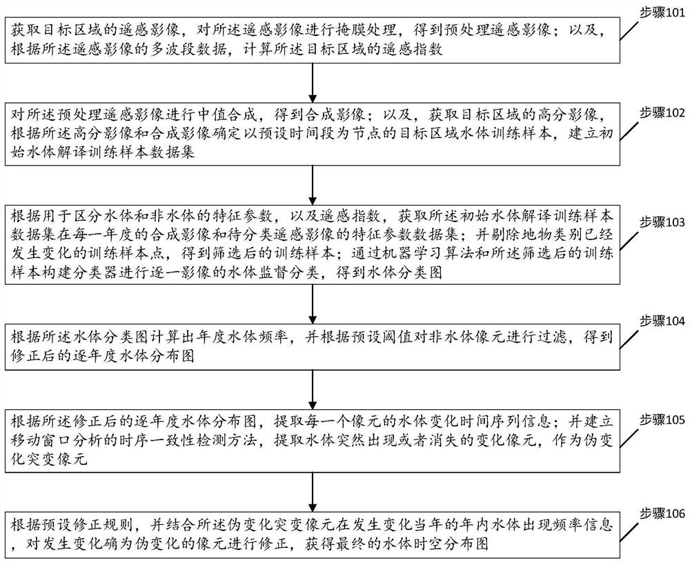
[0044] Please refer to figure 1 , is a flow chart of the steps of a continuous time series water body remote sensing mapping method provided by the embodiment of the present invention, including steps 101 to 106, and each step is specifically as follows:

[0045] Step 101, acquiring a remote sensing image of a target area, performing mask processing on the remote sensing image to obtain a preprocessed remote sensing image; and calculating a remote sensing index of the target area according to the multi-band data of the remote sensing image.

[0046] Specifically, based on the GEE platform, the remote sensing images of the target area are obtained in the whole period. This example is all SR images provided by Landsat5 satellite TM sensor, Landsat7 satellite ETM+ sensor and Landsat8 satellite OLI from 1986 to 2019. Poor quality pixels such as clouds and cloud shadows in the image are masked according to the QA band.

[0047] In another aspect of this embodiment, the continuous ...


PUM


Abstract

The invention discloses a continuous time series water body remote sensing mapping method, proposes a remote sensing image interpretation training sample point automatic update method, time series consistency analysis and false change correction technology, and combines the GEE big data platform to establish a long time series High-precision water system mapping and dynamic monitoring methods solve the problem of time-consuming and labor-intensive continuous-time water body remote sensing mapping and contain a large number of false changes; training samples, which effectively improves the efficiency and accuracy of supervised classification, and at the same time has a high degree of automation and portability; at the same time, the present invention recognizes the time-series consistency of the year-by-year water body classification results, and combines the water body information within the year to establish a water body pseudo Change discrimination and correction rules effectively improve the accuracy of water body dynamic changes and provide accurate long-term water body dynamic information.

Description

technical field [0001] The invention relates to the technical field of water body remote sensing mapping, in particular to a continuous time series water body remote sensing mapping method. Background technique [0002] As an important part of natural productivity, wetlands provide various ecological service values, such as water conservation, flood regulation, migration of nutrients and sediments, and maintenance of biological habitat stability. Due to the impact of climate change and human activities, large areas of wetlands have been destroyed around the world, and the degradation and shrinkage of wetlands has led to extreme climate phenomena (such as floods and droughts) and the reduction of biodiversity. Wetlands are characterized by perennial or seasonal water bodies. Water body mapping based on remote sensing has become an important means of long-term water dynamic monitoring. It can accurately extract the spatial distribution of long-term water bodies and effectively...

Claims


Application Information

Patent Timeline
Patent Type & Authority Patents(China)
IPC IPC(8): G06T5/50G06K9/62G06N3/08G06N20/00
CPCG06T5/50G06N20/00G06N3/08G06T2207/10032G06T2207/20032G06T2207/20081G06T2207/20221G06F18/24323G06F18/214
Inventor 许尔琪李科为
Owner INST OF GEOGRAPHICAL SCI & NATURAL RESOURCE RES CAS
Learn More