Self-adaptive ionosphere model integrity monitoring method

An integrity monitoring and ionospheric technology, applied in the field of satellite navigation, it can solve the problems of poor weighting effect, low usability, inability to accurately reflect the size of the TEC correction number error, etc., to increase practicability, reduce computational overhead, The effect of improving usability

Active Publication Date: 2021-09-10
BEIHANG UNIV
View PDF6 Cites 0 Cited by
  • Summary
  • Abstract
  • Description
  • Claims
  • Application Information

AI Technical Summary

Problems solved by technology

But the disadvantage is that GIVE is too conservative, far larger than the actual error of the model, and cannot accurately reflect the size of the TEC correction number error, which will lead to poor results when GIVE is used as the weight of the ionospheric model. In PPP and long-baseline RTK, The stochastic model constructed by it may be worse than the empirical model, and cannot give full play to the role of the high-precision ionospheric model
Therefore, although the GIVE obtained by this algorithm meets the integrity requirements, the usability is greatly reduced, and it cannot meet the current high-precision positioning requirements for the reliability of the ionospheric model.

Method used


Image

  • Self-adaptive ionosphere model integrity monitoring method
  • Self-adaptive ionosphere model integrity monitoring method
  • Self-adaptive ionosphere model integrity monitoring method

Examples


Embodiment 1

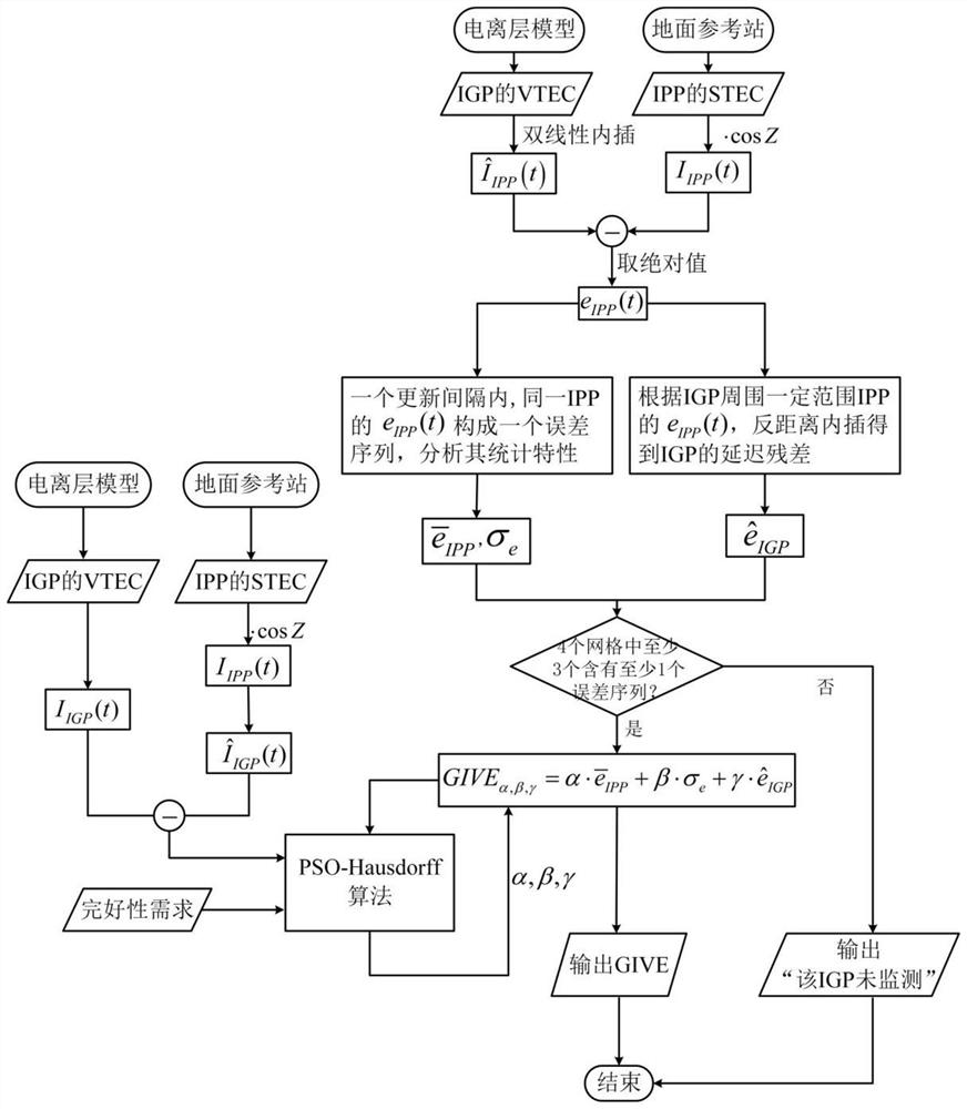
[0109] Select the Global ionosphere map (GIM) released by the Center for Orbit De-termination in Europe (CODE) on March 16, 2014 as the ionosphere model to be evaluated, and the satellite constellation is a single GPS Constellation, the reference stations are 235 stations of the Chinese mainland tectonic environment monitoring network (terrestrial state network).

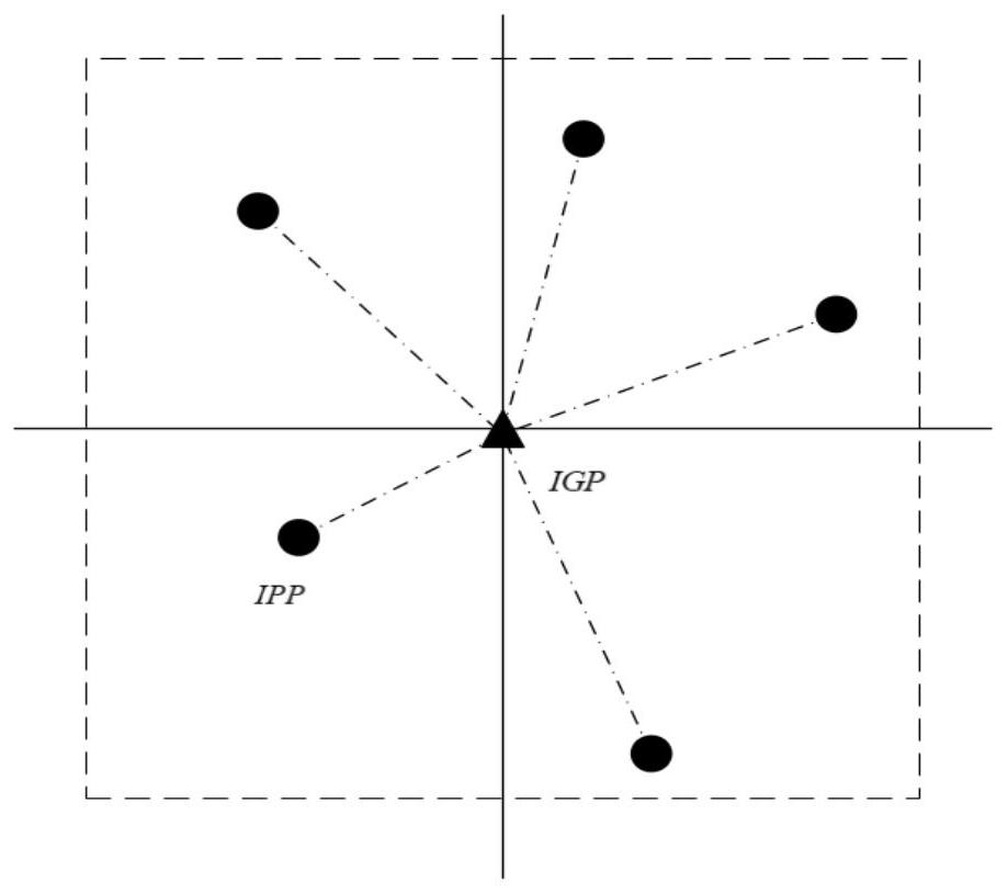
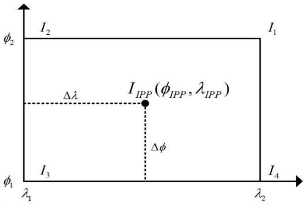
[0110] The observed data of the reference station can be processed to obtain the ionospheric delay observation value I of the puncture point between each reference station and each satellite IPP (t), the ionospheric delay of each puncture point is calculated by using the ionospheric product of GIM, which is used as the calculated value The ionospheric delay residual at the puncture point is calculated every 30 seconds. The update interval of GIVE is 900s, that is, the length of the error sequence within an update interval is m=30, and the integrity requirement of the ionospheric model is set to 99.9%.

[0111] Two...


PUM


Abstract

The invention discloses a self-adaptive ionosphere model integrity monitoring method. The method realizes real-time and accurate monitoring of ionosphere model integrity, takes a grid ionospheric vertical error (GIVE) as a protection threshold of ionosphere model integrity, delimits the error of the delay correction number of an ionosphere model according to ionosphere delay extracted GNSS real-time observation data, realizes real-time and accurate limitation of the GIVE on the ionosphere error by introducing an adjustment coefficient and an adaptive optimization algorithm of the adjustment coefficient, and greatly improves the availability of the system under the condition of ensuring the integrity; and the method has a wide application prospect in ionosphere anomaly monitoring and high-precision positioning.

Description

technical field [0001] The invention belongs to the technical field of satellite navigation, and in particular relates to a method for realizing real-time and accurate monitoring of ionospheric model integrity through an adaptive ionospheric model error bounding algorithm. Background technique [0002] Ionospheric delay is one of the key error sources for high-precision positioning of the global satellite navigation system, and the error impact can reach several meters or even tens of meters. For dual-frequency users, the ionospheric delay can be corrected by linear combination of observations, while for single-frequency users, it is necessary to use the ionospheric delay correction model to weaken the influence of the error source, such as the international reference ionospheric model, Krobb Klobuchar and Global Ionospheric Maps (GIMs), etc. At present, most studies focus on comparing and evaluating the accuracy of different ionospheric models, but little attention is paid...

Claims


Application Information

Patent Timeline
Patent Type & Authority Applications(China)
IPC IPC(8): G01S19/07
CPCG01S19/072Y02A90/10
Inventor 施闯薛宇郑福
Owner BEIHANG UNIV
Why Eureka
Try Eureka