Method for reconstructing high-temporal-spatial-resolution land subsidence information based on machine learning

A space-time resolution and land subsidence technology, applied in machine learning, instruments, computer components, etc., can solve problems such as high manpower and time costs, and failure to consider comprehensive factors affecting subsidence

Active Publication Date: 2021-09-10
CAPITAL NORMAL UNIVERSITY
View PDF5 Cites 2 Cited by
  • Summary
  • Abstract
  • Description
  • Claims
  • Application Information

AI Technical Summary

Problems solved by technology

However, these interpolation methods assume that the missing data and the existing data have the same statistical and geometric structure, and do not consider the comprehensive factors of settlement, such as hydrology, geological background, dynamic and static loads, etc.
In addition, the traditional spatial interpolation method can only obtain instantaneous subsidence information, and to obtain long-term subsidence information, it is necessary to repeat the interpolation calculation of the subsidence information at each moment, which requires high manpower and time costs

Method used


Image

  • Method for reconstructing high-temporal-spatial-resolution land subsidence information based on machine learning
  • Method for reconstructing high-temporal-spatial-resolution land subsidence information based on machine learning
  • Method for reconstructing high-temporal-spatial-resolution land subsidence information based on machine learning

Examples


Embodiment 1

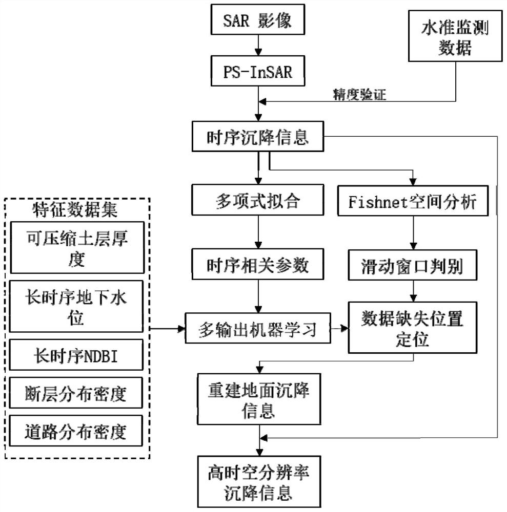
[0054] see figure 1 , the present invention proposes a method for reconstructing land subsidence information with high temporal and spatial resolution based on machine learning, the specific method steps are as follows:

[0055] S1. Obtain SAR observation image data covering the study area. Single-look complex products (SLC) in SAR images contain phase and amplitude information, enabling deformation monitoring. The present invention selects SLC products in SAR images to prepare data for PS-InSAR processing.

[0056] S2. Acquiring feature data sets within the scope of the research area. The feature dataset consists of influencing factors of land subsidence, including compressible soil thickness, groundwater level, fractures, building distribution, traffic loads, etc. Among them, the compressible soil layer thickness data includes the thickness of the compressed layer group at different depths of the floor and the thickness of the total compressed layer group; the groundwater...

Embodiment 2

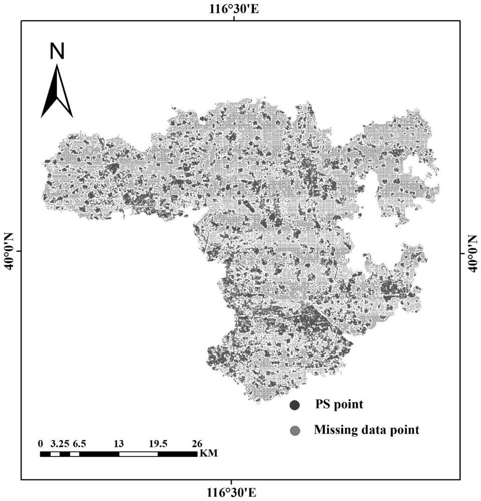
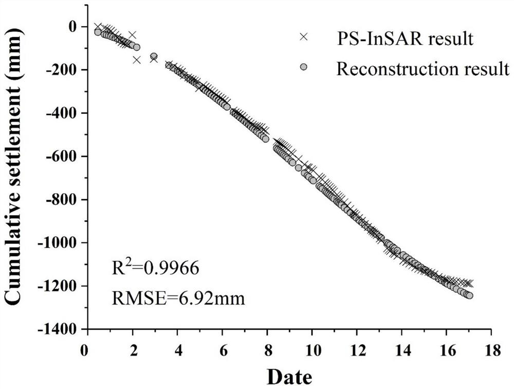
[0078] see Figure 2-4 , the difference between this implementation mode and the specific implementation mode one is:

[0079] Beijing is an area with severe land subsidence disasters in the North China Plain. This implementation case selects the Beijing Plain as the research area. Below, the feasibility of the present invention is further supplemented and proved by applying the method proposed by the present invention to an actual case.

[0080] Step 1. Obtain 55 Envisat ASAR (2003.6-2010.9) and 81 Radarsat-2 (2010.11.22-2020.1.10) SLC products covering the Beijing area.

[0081] Step 2: Obtain a feature dataset covering the Beijing area. The compressible soil layer thickness data in the characteristic data set includes the thickness of the first compressible layer group whose buried depth is less than 100m, the thickness of the second compressible layer group whose buried depth is less than 300m, the thickness of the second compressible layer group whose buried depth is grea...


PUM


Abstract

The invention discloses a method for reconstructing high temporal-spatial resolution land subsidence information based on machine learning. The method comprises the following steps: S1, acquiring SAR observation image data covering a research area range; S2, acquiring a feature data set covering a research area range; S3, acquiring long-time-sequence land subsidence information; S4, based on the long-time-sequence land subsidence information, fitting the subsidence curve by using a polynomial fitting method, and obtaining related parameters of a polynomial; S5, positioning a data missing position by combining Fishnet spatial analysis and a sliding window discrimination method; S6, utilizing machine learning to reconstruct settlement information of a data missing position; and S7, superposing the reconstructed settlement information and a PS-InSAR result, and finally obtaining the ground settlement information with high temporal-spatial resolution. According to the method, the land subsidence information of an area with low spatial-temporal coherence and poor stability in a city is reconstructed by using a multi-output machine learning method, and finally, the land subsidence information with large range, high precision and high spatial-temporal resolution is obtained.

Description

technical field [0001] The invention belongs to the technical field of urban geological disasters, and in particular relates to a method for reconstructing land subsidence information with high temporal and spatial resolution based on machine learning. Background technique [0002] Land subsidence is a kind of geological disaster caused by the consolidation and compression of underground loose strata under the influence of human activities or natural factors, and the ground elevation drops. Land subsidence will cause hazards such as cracking of walls, tilting of buildings, damage to pipelines, backflow of seawater, etc., which will have a huge impact on people's production and life. Effective monitoring of land subsidence and acquisition of subsidence information with high temporal and spatial resolution are necessary prerequisites for the prevention and control of urban land subsidence disasters. [0003] The monitoring technology of land subsidence mainly includes levelin...

Claims


Application Information

Patent Timeline
Patent Type & Authority Applications(China)
IPC IPC(8): G06K9/62G06N20/00G01C5/00
CPCG06N20/00G01C5/00G06F18/10
Inventor 柯樱海吕明苑李小娟郭琳宫辉力张可王展鹏朱丽娟
Owner CAPITAL NORMAL UNIVERSITY
Why Eureka
Try Eureka