A method and device for spatial scale selection of mass landslides

A space-scale, group-based technology, applied in the direction of instruments, data processing applications, geographic information databases, etc., can solve the problems of lack of scale selection methods, inability to accurately locate and analyze landslides, subjectivity, etc.

Active Publication Date: 2021-11-09
GUANGZHOU INST OF GEOGRAPHY GUANGDONG ACAD OF SCI +1
View PDF6 Cites 0 Cited by
  • Summary
  • Abstract
  • Description
  • Claims
  • Application Information

AI Technical Summary

Problems solved by technology

Administrative units are usually widely used in landslide research at various large regional scales. The main advantage is that the evaluation results can be easily compared among different administrative units. It is difficult to study the relationship between landslides and influencing factors, and the scale of landslides based on administrative units is relatively large, so it is impossible to accurately locate and analyze landslides
Different from administrative units, small watershed units are generally only applicable to the study of landslides at small and medium regional scales. According to the scope and scale of the research, they can be subdivided into sub-watersheds at different levels. There are generally differences in natural landforms, meteorological and hydrological environmental conditions within a watershed unit, and small watershed units can express this difference more accurately; the disadvantage is that the choice of small watershed scale is arbitrary and subjective, and lacks an effective scale Method of choosing
The slope unit is suitable for small-scale and large-scale landslide analysis. Its biggest advantage is that the natural slope unit is the basic unit in the development of the landslide, and its physical meaning is clear. However, in research and practice, the positioning of the natural slope unit The division is difficult, mainly because landslides of different scales correspond to different natural slope units, and the impact of landslide scale on the division of natural slope units is not considered, and mass landslides often exist not only in a single slope unit, but can even Said to be a slope unit that spans multiple
Grid units are generally especially suitable for the evaluation of small-scale landslide sensitivity. Their advantages lie in their simple data structure and ease of calculation, which is conducive to the comprehensive analysis of evaluation results. The disadvantage is that they do not have actual physical meaning for the evaluation unit.
Therefore, there is currently no method for selecting the scale suitability of mass landslides with clear physical meaning, and relevant research is urgently needed to provide scientific basis for information extraction, risk assessment, disaster warning and forecasting, and disaster prevention and control of mass landslides.

Method used


Image

  • A method and device for spatial scale selection of mass landslides
  • A method and device for spatial scale selection of mass landslides
  • A method and device for spatial scale selection of mass landslides

Examples


Embodiment Construction

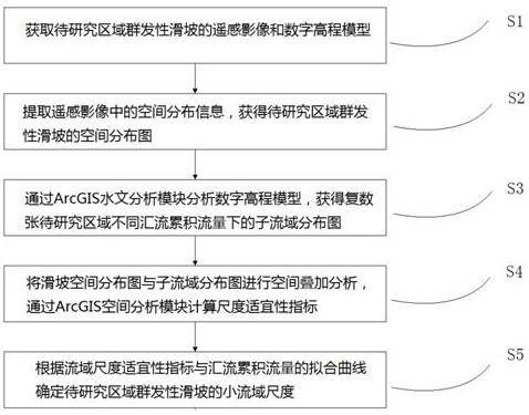
[0059] see figure 1 , which is a flowchart of a spatial scale selection method for mass landslides according to an embodiment of the present invention.

[0060] A method for selecting spatial scales of mass landslides according to the present invention includes:

[0061] S1 Obtain remote sensing images and digital elevation models of mass landslides in the area to be studied;

[0062] S2 extracts the spatial distribution information in the remote sensing image, and obtains the spatial distribution map of mass landslides in the area to be studied;

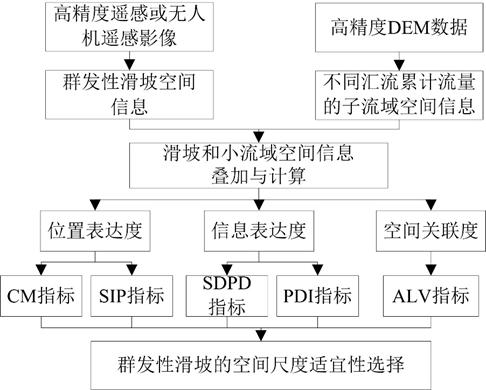
[0063] S3 analyzes the digital elevation model through the ArcGIS spatial analysis module, and obtains a plurality of sub-basin distribution maps under different confluence accumulation flows in the area to be studied;

[0064] S4 performs spatial overlay analysis on each sub-basin distribution map and the landslide spatial distribution map, and calculates the watershed-scale suitability index through the ArcGIS spatial analysis m...


PUM


Abstract

The invention discloses a method and device for selecting spatial scales of mass landslides. Through high-precision digital elevation models and landslide spatial data, the ArcGIS spatial correlation analysis method is used, and the geographical location expression degree, information expression degree, and spatial correlation index are used. , taking the small watershed with clear physical meaning as the basic unit, analyzing the relationship curve between the index and the value, and defining the small watershed scale that is most suitable for the analysis of mass landslides, it can be widely used in landslide spatial information extraction, risk assessment, disaster warning and forecasting, Disaster prevention and other aspects, has important theoretical and practical significance.

Description

technical field [0001] The invention relates to the technical field of natural disaster prevention, in particular to a method and device for selecting spatial scales of mass landslides, a readable storage medium and a computer control system. Background technique [0002] Heavy rainfall, especially extreme rainfall, often induces large-scale and mass landslide disasters. How to choose a suitable spatial scale to more accurately express the spatial distribution characteristics and information of mass landslides is an important condition for improving landslide disaster forecasting and early warning, which has great significance. important practical significance. [0003] The spatial distribution of landslides has obvious spatial autocorrelation and scale dependence, and the spatial distribution patterns of landslides depicted at different scales have different characteristics. If the selected scale is too large, the process of landslide data spatialization will directly lead...

Claims


Application Information

Patent Timeline
Patent Type & Authority Patents(China)
IPC IPC(8): G06K9/00G06F16/29G06Q10/06G06Q50/26
CPCG06F16/29G06Q10/0639G06Q50/26
Inventor 王钧苟登文宫清华李子豪刘博文袁少雄陈军
Owner GUANGZHOU INST OF GEOGRAPHY GUANGDONG ACAD OF SCI
Why Eureka
Try Eureka