Landslide emergency treatment engineering exploration design method based on remote sensing assistance of small unmanned aerial vehicle

A design method, machine-based remote sensing technology, applied to measuring devices, instruments, surveying, mapping and navigation, etc., can solve the problem of low work efficiency, affecting the accuracy of engineering survey and design results, and difficult to achieve "fast" and "accurate" implementation goals issues such as improving work efficiency and accuracy of results, assisting engineering geological survey and design, and improving intuitive visualization effects

Inactive Publication Date: 2016-03-30
CHINA THREE GORGES UNIV
View PDF3 Cites 35 Cited by
  • Summary
  • Abstract
  • Description
  • Claims
  • Application Information

AI Technical Summary

Problems solved by technology

[0004] 2. The efficiency of traditional large-scale topographic map on-site measurement is low, and the non-prism total station or GPS-RTK measurement technology is often restricted by the landslide environment and cannot be implemented. In addition, these topographic maps are generated based on discrete "point" measurement interpolation The overall mapping accuracy is not high
At the same time, a single line-drawn topographic map cannot intuitively reflect the comprehensive characteristics of landslides (including topography, vegetation, structures, etc.), which seriously affects the efficiency of engineering exploration, such as the one-time accurate layout of exploration profiles and...

Method used


Image

  • Landslide emergency treatment engineering exploration design method based on remote sensing assistance of small unmanned aerial vehicle
  • Landslide emergency treatment engineering exploration design method based on remote sensing assistance of small unmanned aerial vehicle
  • Landslide emergency treatment engineering exploration design method based on remote sensing assistance of small unmanned aerial vehicle

Examples


Embodiment Construction

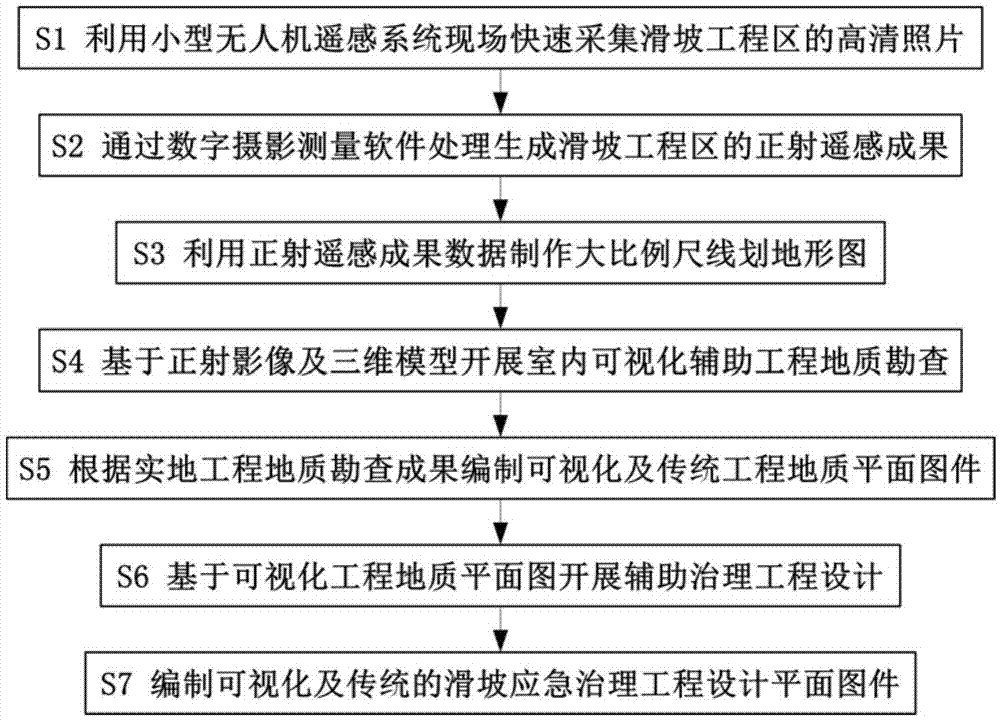
[0028] The technical solution of the present invention will be further described in conjunction with the accompanying drawings. Such as figure 1 As shown in the present invention, a method for landslide emergency control project survey and design based on small unmanned aerial vehicle remote sensing, the technical steps include: using the small unmanned aerial vehicle remote sensing system to quickly collect high-definition photos S1 of the landslide engineering area on the spot; The measurement software processes and generates ortho-remote sensing results S2 of the landslide engineering area; uses the data of ortho-remote sensing results to make large-scale line-drawn topographic maps S3; conducts indoor visualization-assisted engineering geological survey S4 based on orthophoto images and 3D models; Results Compilation of visualization and traditional engineering geological plan S5; Auxiliary control engineering design S6 based on visualized engineering geological plan; Comp...


PUM


Abstract

The invention relates to a landslide emergency treatment engineering exploration design method based on remote sensing assistance of a small unmanned aerial vehicle. The method is characterized by comprising the following steps: rapidly acquiring a high-definition picture of a landslide engineering region in field by using a small unmanned aerial vehicle remote sensing system; generating an orthophoto remote sensing result of the landslide engineering region through digital photogrammetry software processing; making a large-scale line global map by using the orthophoto remote sensing result; carrying out indoor visual auxiliary engineering geological investigation based on an orthophoto and a three-dimensional model; programming a visual conventional engineering geological map according to an on-site engineering geological investigation result; carrying out an auxiliary treatment engineering design based on the visual engineering geological map; programming a visual and conventional landslide emergency treatment engineering design plane map.

Description

technical field [0001] The invention relates to an improved engineering survey and design method, in particular to a landslide emergency control engineering survey and design method based on the remote sensing assistance of a small unmanned aerial vehicle. Background technique [0002] The investigation and design of emergency control engineering is an important part of landslide disaster prevention and control engineering. It is generally an important implementation basis for carrying out emergency control projects in order to avoid the continuous development of disasters and eliminate disaster hazards as soon as possible after landslide disasters occur suddenly or in part. Therefore, on the basis of complying with the relevant norms of landslide prevention and control engineering survey and design, emergency control engineering survey and design should pay special attention to its timeliness, that is, to highlight the word "fast". At the same time, the investigation and de...

Claims


Application Information

Patent Timeline
IPC IPC(8): G01C11/00
CPCG01C11/00
Inventor 黄海峰易武林海玉吕奕铭杜晓飞闫国强王焕蒋赏邓永煌赵红渠张国栋易庆林童时岸刘凯
Owner CHINA THREE GORGES UNIV
Why Eureka
Try Eureka