Eureka AIR delivers breakthrough ideas for toughest innovation challenges, trusted by R&D personnel around the world.

Forest ecological environment condition evaluation method based on remote sensing technology

A technology of ecological environment and remote sensing technology, applied in the field of environmental monitoring, can solve the problems of unfavorable continuous space and large-area monitoring, monitoring environmental damage, long cycle, etc., and achieve the effect of easy promotion and use

Pending Publication Date: 2021-10-26
SHANDONG JIANZHU UNIV
View PDF0 Cites 3 Cited by
  • Summary
  • Abstract
  • Description
  • Claims
  • Application Information

AI Technical Summary

Problems solved by technology

[0003] Although the ground measurement method has high precision in forest ecosystem monitoring, it requires high labor intensity, long cycle, high cost, and may even cause some damage to the monitoring environment, and it is not conducive to the realization of continuous space and large-area monitoring

Method used


Image

  • Forest ecological environment condition evaluation method based on remote sensing technology
  • Forest ecological environment condition evaluation method based on remote sensing technology
  • Forest ecological environment condition evaluation method based on remote sensing technology

Examples


Embodiment 1

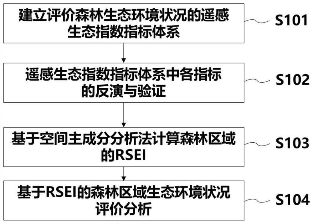
[0043] Such as figure 1 Shown, the present invention is based on the forest eco-environmental state evaluation method of remote sensing technology and specifically includes the following processes:

[0044] S101 Establish a remote sensing ecological index system for evaluating forest ecological environment conditions

[0045]Selecting indicators that can represent the ecological environment of the forest area to construct the forest remote sensing ecological index index system, it should be noted that the selected indicators can not only scientifically reflect the differences in the evaluation of forest objects, but also meet the requirements of the evaluation indicators in the extraction process based on remote sensing technology. requirements for spatial and temporal resolution. Finally, you can choose 4-8 indicators, including: Greenness (Greenness), vegetation and soil moisture (Wetness), heat (Heat), forest canopy chlorophyll content (ForestCanopy Chlorophyll Content-FCC...

Embodiment 2

[0061] Example 2. Evaluation of Tamarix Forest Ecological Environment Effects Based on Remote Sensing Ecological Index Method

[0062] The inventor took Tamarix forest in Changyi National Marine Ecological Special Reserve as the research object, and carried out a series of monitoring and evaluation studies on the ecological environment of the protected area based on remote sensing technology, including the evaluation of the ecological environment effect of Tamarix forest based on RSEI.

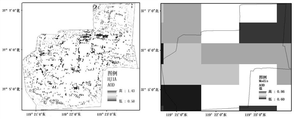
[0063] In terms of RSEI-based evaluation of the environmental effects of ecological restoration in protected areas, this study uses six types of representative and near-real-time indicators that can represent the ecological environment of protected areas as the evaluation indicators of the remote sensing ecological index proposed in this study, namely AOD, salt degree, greenness, humidity, heat, and dryness, and obtained the results of each index through the improved dark pixel method, multiple...


PUM


Abstract

The invention provides a forest ecological environment condition evaluation method based on a remote sensing technology, and belongs to the field of environment monitoring. According to the method, a forest remote sensing ecological index system is constructed, and a remote sensing ecological index method is adopted to evaluate the ecological environment condition of a forest area. The following steps are included: firstly, selecting indexes capable of representing the forest ecological environment condition to construct the forest remote sensing ecological index system; then, referring to the inversion model of each existing index, establishing an inversion model suitable for evaluating the forest region, and eliminating the dimension inconsistency of each inversion result through a normalization method; and finally, obtaining the RSEI for evaluating the forest region through a spatial principal component analysis method, and evaluating and analyzing the ecological environment condition of the forest. According to the method, the ecological environment condition of the forest region can be simply and visually obtained, the method has certain universality, scientific basis and technical guidance can be provided for protection, restoration and management of the forest region, and development of a regional scale remote sensing ecological index universality model is promoted.

Description

technical field [0001] The invention belongs to the field of environmental monitoring, and in particular relates to an application method of remote sensing technology in ecological environment monitoring. Background technique [0002] With the in-depth development of ecological civilization construction, people pay more and more attention to regional ecological environment conditions, and the requirements for timeliness, continuity, and diversity of ecological environment monitoring and evaluation also increase. Applications in environmental monitoring provide an opportunity. [0003] Although the ground measurement method has high precision in forest ecosystem monitoring, it requires high labor intensity, long cycle, high cost, and may even cause some damage to the monitoring environment, and it is not conducive to the realization of continuous space and large-area monitoring . [0004] At present, remote sensing technology, as an efficient means of forest ecological envi...

Claims


Application Information

Patent Timeline
IPC IPC(8): G06K9/00G06K9/62G06Q10/06G06Q50/26
CPCG06Q10/06393G06Q50/26G06F18/2135G06F18/2431G06F18/2415
Inventor 王晋陈飞勇韩萍刘兵武道吉李锦煜付萍杰刘耀辉沈雪杨志刚徐林煦许思思宋扬
Owner SHANDONG JIANZHU UNIV
Why Eureka
Eureka Blog
Learn More