System and method suitable for combined orbit determination of networking low-orbit satellites

A technology for low-orbit satellites and satellites, which is applied in the field of satellite orbit determination, which can solve the problems of autonomous, real-time, and high-precision orbit determination of LEO constellation satellites, and achieve high-precision orbit determination, high-precision orbit determination, and improved precision.

Active Publication Date: 2021-11-02
重庆两江卫星移动通信有限公司
View PDF10 Cites 1 Cited by
  • Summary
  • Abstract
  • Description
  • Claims
  • Application Information

AI Technical Summary

Problems solved by technology

[0004] The purpose of the present invention is to provide a system and method suitable for joint orbit determination of low-orbit satellites in a network, and solve the situation that there are LEO satellite ground tracking stations in only some areas Under the current situation, it cannot satisfy the problem of autonomous, real-time and high-precision orbit determination of LEO constellation satellites

Method used


Image

  • System and method suitable for combined orbit determination of networking low-orbit satellites
  • System and method suitable for combined orbit determination of networking low-orbit satellites
  • System and method suitable for combined orbit determination of networking low-orbit satellites

Examples


Embodiment

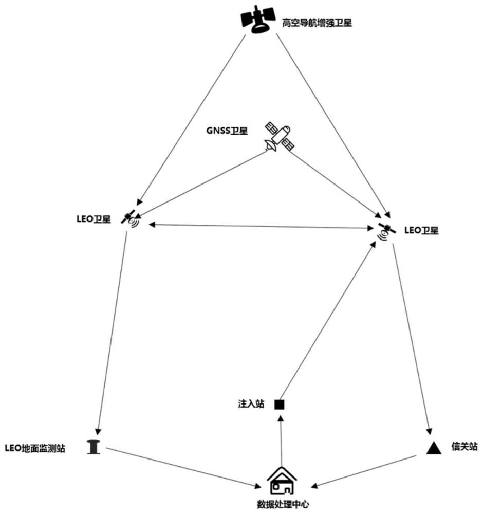
[0062] A system suitable for joint orbit determination of low-orbit satellites in a network, such as figure 1 shown, including the space part and the ground part;

[0063] Space part:

[0064] Includes multiple LEO constellation satellites, a GNSS satellite, and a high-altitude navigation augmentation satellite. Among them, each LEO constellation satellite has the same structure, and is equipped with a spaceborne GNSS receiver (for measuring the distance between the LEO constellation satellite and the GNSS satellite), and a laser reflector (for the ground tracking station to measure and track the LEO constellation satellite) And the on-board computer; at the same time, each LEO constellation satellite can establish a two-way inter-satellite link (ranging and data transmission) with the surrounding LEO constellation satellites; GNSS satellites are used to broadcast GNSS ranging signals; high-altitude satellite-based augmentation satellites, Used to broadcast GNSS corrections ...
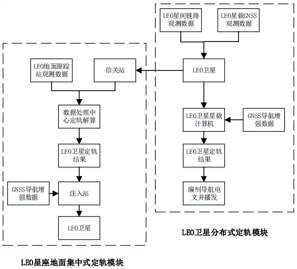
Embodiment 2

[0116] On the basis of Embodiment 1, this embodiment proposes a method suitable for joint orbit determination of networked low-orbit satellites, including steps:

[0117] S1: Obtain observation data and measurement data;

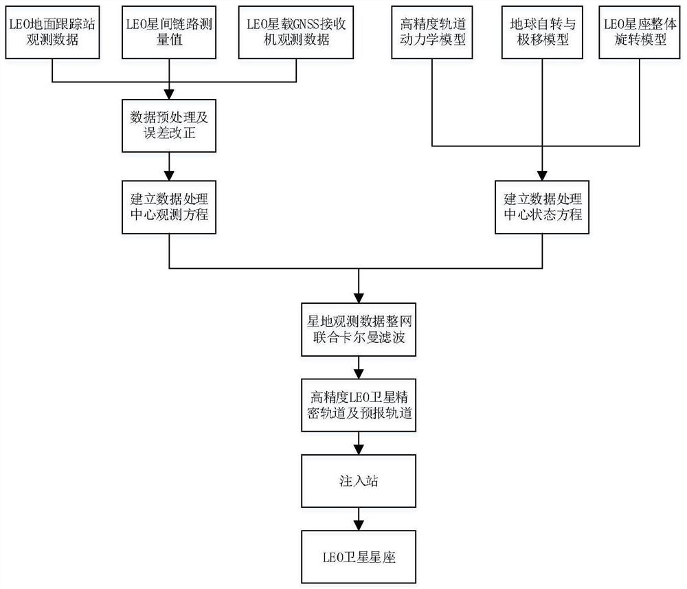
[0118] Among them, the observation data is obtained by tracking and measuring the LEO constellation satellites within the trackable range by the ground tracking station; the measurement data includes the distance between the LEO constellation satellite and the surrounding LEO constellation satellites (inter-satellite link measurement value) and the distance between the LEO constellation satellite and GNSS distance to the satellite (measurements transmitted by the on-board GNSS receiver);

[0119] S2: Obtain the predicted orbit information of each LEO constellation satellite according to the observation data and measurement data;

[0120] S3: Obtain the orbit information of the LEO constellation satellites according to the measurement data and predicted orbi...


PUM


Abstract

The invention discloses a system and method suitable for combined orbit determination of networking low-orbit satellites. The system comprises an LE0 constellation ground centralized orbit determination module and an LEO constellation distributed orbit determination module. The LE0 constellation ground centralized orbit determination module is used for acquiring observation data and measurement data, and acquiring predicted orbit information of each LE0 constellation satellite according to the observation data and the measurement data; and the LEO constellation distributed orbit determination module is used for acquiring the orbit information of the LEO constellation satellite according to the measurement data and the predicted orbit information. The invention aims to provide a system and a method suitable for combined orbit determination of networking low-orbit satellites, and solves the problem that autonomous, real-time and high-precision orbit determination of LEO constellation satellites cannot be met under the condition that only a part of areas have LEO satellite ground tracking stations.

Description

technical field [0001] The invention relates to the technical field of satellite orbit determination, in particular to a system and method suitable for joint orbit determination of networked low-orbit satellites. Background technique [0002] In recent years, many major countries and companies in the world have successively proposed and begun to deploy low-orbit satellite constellations for Internet, Internet of Things, and navigation enhancement services. It is foreseeable that the low-orbit satellite constellation will integrate navigation, communication, remote sensing and other functions in the future, which will be the focus of satellite navigation / communication development in the next stage. The use of low-orbit satellite constellations can promote the further development of satellite navigation systems in the "smart era" towards the integration of satellite-based and ground-based augmentation technologies and the integration of communication / remote sensing / navigation ...

Claims


Application Information

Patent Timeline
Patent Type & Authority Applications(China)
IPC IPC(8): B64G3/00B64G1/10B64G1/24
CPCB64G3/00B64G1/1085B64G1/1014B64G1/242
Inventor 谭理庆曹阳彭琦杨鑫
Owner 重庆两江卫星移动通信有限公司
Why Eureka
Try Eureka