A ship-borne GNSS-assisted Beidou navigation satellite orbit determination method

A Beidou navigation and Beidou satellite technology, which is used in satellite radio beacon positioning systems, measuring devices, instruments, etc., to improve the accuracy of orbit determination, weaken system errors, and improve the precise orbit determination configuration of BDS.

Inactive Publication Date: 2017-09-15
CHINESE ACAD OF SURVEYING & MAPPING
View PDF3 Cites 0 Cited by
  • Summary
  • Abstract
  • Description
  • Claims
  • Application Information

AI Technical Summary

Problems solved by technology

[0005] The object of the present invention is to provide a kind of shipborne GNSS assisted Beidou navigation satellite orbit determination method, thus solve the aforementioned problems existing in the prior art

Method used


Image

  • A ship-borne GNSS-assisted Beidou navigation satellite orbit determination method
  • A ship-borne GNSS-assisted Beidou navigation satellite orbit determination method
  • A ship-borne GNSS-assisted Beidou navigation satellite orbit determination method

Examples


specific Embodiment

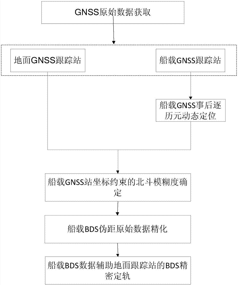
[0110] The shipborne GNSS assisted Beidou satellite determination method provided in the embodiment of the present invention is implemented according to the following steps:

[0111] Step 1: Obtain shipborne GNSS raw data and terrestrial GNSS raw data:

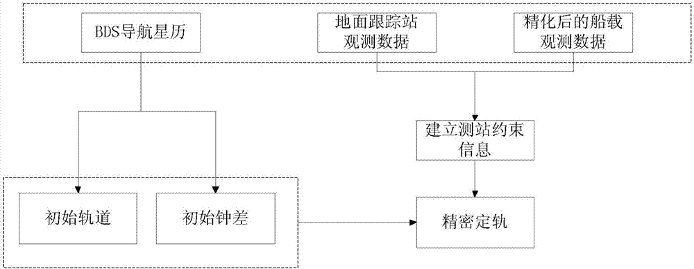
[0112] Shipborne and terrestrial GNSS raw data are at least compatible with BDS and GPS dual systems, which include GNSS satellite navigation ephemeris and satellite raw observation data; the satellite raw observation data include pseudorange observations and carrier phase observations of two frequencies;

[0113] Step 2, Kalman filter-based shipboard GNSS post-event dynamic positioning by epoch:

[0114] The kinematic models of large cargo ships, cruise ships and other ship-borne GNSS platforms are relatively obvious, and their routes are preset, and the platform movement is relatively slow and stable. Therefore, the Kalman filter method is used to perform high-precision ship-borne GNSS post-event dynamic positioning by epoc...


PUM


Abstract

The invention discloses an onboard GNSS-assisted Beidou navigation satellite orbit determination method, and relates to the technical field of earth observation and navigation. The method, by research of key technologies such as high-precision onboard GNSS tracking station epoch-by-epoch dynamic positioning, onboard GNSS Beidou satellite ambiguity determination, onboard GNSS-assisted Beidou satellite orbit determination, makes full use of the onboard (such as cargo ships and cruise ships in the oceans) GNSS data, optimizes tracking station configuration in BDS orbit determination, and assists precise Beidou navigation satellite orbit determination. The BDS precise orbit determination configuration is greatly enriched and BDS precision orbit system error is weakened because cargo ship onboard device air routes are everywhere in the oceans. Since there are many cruise ship routes, a dynamic location fills in the blank area of the tracking station, provides richer raw data for BDS precision orbit determination, improves the BDS precision orbit accuracy, and provides users with a more accurate track product.

Description

technical field [0001] The invention relates to the technical field of earth observation and navigation, in particular to a method for determining the orbit of a ship-borne GNSS assisted Beidou navigation satellite. Background technique [0002] my country's BeiDou Navigation Satellite System ("BDS" for short) consists of a space terminal, a ground terminal and a user terminal. At present, 22 satellites have been launched, and 14 satellites are operating normally in orbit, stably transmitting data and providing services. They adopt Geostationary Earth Orbit (GEO) and Inclined Geosynchronous Satellite Orbit (IGSO) And (Medium Earth Orbit, MEO) hybrid constellation design, while meeting the positioning and navigation services in the Asia-Pacific region, it has begun to move towards global networking. [0003] At present, the distribution status of global BDS-compatible tracking stations is as follows: ① China and Europe are relatively densely distributed, and other regions ar...

Claims


Application Information

Patent Timeline
Patent Type & Authority Patents(China)
IPC IPC(8): G01S19/42G01S19/44
CPCG01S19/423G01S19/44
Inventor 党亚民张龙平薛树强谷守周王虎易慧
Owner CHINESE ACAD OF SURVEYING & MAPPING
Why Eureka
Try Eureka