Community security and protection control system and method based on Internet of Things
What is AI technical title?
AI technical title is built by Patsnap AI team. It summarizes the technical point description of the patent document.
A control system, the technology of the Internet of Things, which is applied to the traffic control system of road vehicles, traffic control system, radio wave measurement system, etc., can solve the problem of inaccurate analysis of the driving speed of fire trucks
Inactive Publication Date: 2021-11-09
江苏梦想物联有限公司
View PDF7 Cites 4 Cited by
Summary
Abstract
Description
Claims
Application Information
AI Technical Summary
This helps you quickly interpret patents by identifying the three key elements:
Problems solved by technology
Method used
Benefits of technology
Problems solved by technology
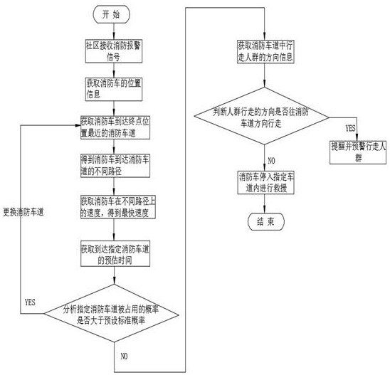
[0003] Especially when a fire or other emergency occurs in the community, the community work at this time is extremely important; the community needs to arrange for fire vehicles to reach the end position in a short time to put out the fire, so as to protect the lives of residents and the public property of the community Safety; for this, it is necessary to arrange the optimal path for the fire truck to the terminal position, thereby reducing the time for the fire truck to wait on the path; in the Chinese patent: the application number is 202110087151.5, and the invention patent with the publication date of 2021.5.18 discloses "a A path planning method based on equivalent road resistance analysis and considering the dynamic availability of fire hydrants". In the manual, the traffic speed of fire trucks in road sections is judged by vehicle density; but in the analysis process, only the speed of each road section is calculated. However, the road section is divided into main road sections and small road sections, and the specific speed consumed by each road section is not judged, but only the speed of the overall road section is analyzed; the analysis of the speed of fire trucks on specific road sections is not accurate. Therefore, This problem needs to be improved to ensure that fire trucks can ensure the safety of the community in a timely manner. In this process, the Internet of Things is needed to assist it, so that information can be fed back to the terminal in a timely manner at any location in the community.
Method used
Image
Click on the blue label to locate the original text in one second.
Reading with bidirectional positioning of images and text.
Examples
Embodiment 1
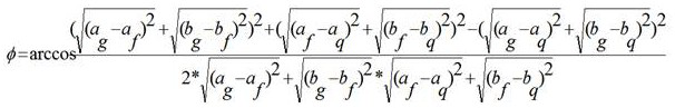
[0101] Example 1: The obtained real-time walking position of pedestrians in the community is {(a g ,b g ),(a f ,b f ),(a q ,b q )}={(150,450),(620,1000),(1200,1800)}, o refers to the number of steps of pedestrians; the position coordinates of the vertices of the fire lane are ={(900,1200),(900,540),(1500,1200),(1500,540)};
[0102] To establish a rectangular coordinate system, the specific formula for the first included angle is as follows:
[0103] Set, the coordinates of the pedestrian’s location in the community (a f , b f )=(620,1000) and the line between the extension line of this position and the intersection position (950,1240) of the fire lane, and the second angle between the line and the horizontal direction, the calculation steps of the second angle as follows:
[0104] Establish a Cartesian coordinate system, then ;
[0105] If the detection result is 90>40, it will give an early warning and remind pedestrians not to continue driving in the current d...
Embodiment 2
[0106] Example 2: The real-time walking position of pedestrians in the community is obtained as {(a g ,b g ),(a f ,b f ),(a q ,b q )}={(1000,1600),(1250,1750),(1100,1300)}, o refers to the number of steps of pedestrians; the position coordinates of each vertex of the fire lane are ={(900,1200),(900,540),(1500,1200),(1500,540)};
[0107] To establish a rectangular coordinate system, the specific formula for the first included angle is as follows:
[0108] Set, the coordinates of the pedestrian’s location in the community (a f , b f )=(1250,1750) and the line between the extension line of this position and the intersection position (950,1240) of the fire lane, and the second angle between the line and the horizontal direction, the calculation steps of the second angle as follows:
[0109] To establish a rectangular coordinate system, then;
[0110] If 90>60 is detected, it will give an early warning and remind pedestrians not to continue driving in the current dir...
PUM
Abstract
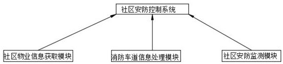
The invention discloses a community security and protection control system and method based on the Internet of Things, and relates to the technical field of instruction sending and alarming. The system comprises a community property information acquisition module, a fire lane information processing module and a community security and protection monitoring module. The community property information acquisition module is used for receiving an alarm signal of a fire fighting truck in a community and acquiring information of the fire fighting truck in the community; the fire lane information processing module is used for arranging an optimal path for the fire fighting truck to reach the final position from the community position according to the acquired information, so that the fire fighting truck can reach the final position at the fastest speed; the community security and protection monitoring module is used for acquiring position information when pedestrians walk in a community and monitoring the relative positions of the pedestrians and the fire lane, so that the pedestrians in the community cannot prolong the parking time of the fire fighting truck in the fire lane; the safety of the community can be guaranteed through the community security and protection monitoring module; through the alarm information, the fire fighting truck can reach the rescue position at the fastest speed.
Description
technical field [0001] The invention relates to the technical field of command sending and alarming, in particular to a community security control system and method based on the Internet of Things. Background technique [0002] As a hot research topic, the security control work in the community has been extensively studied; the community is a large group of several groups gathered in a certain field, and the community is the microcosm of the macro society; the community is a specific area. population groups; [0003] Especially when a fire or other emergency occurs in the community, the community work at this time is extremely important; the community needs to arrange for fire vehicles to reach the end position in a short time to put out the fire, so as to protect the lives of residents and the public property of the community Safety; for this, it is necessary to arrange the optimal path for the fire truck to the terminal position, thereby reducing the time for the fire tru...
Claims
Application Information
Patent Timeline
Application Date:The date an application was filed.
Publication Date:The date a patent or application was officially published.
First Publication Date:The earliest publication date of a patent with the same application number.
Issue Date:Publication date of the patent grant document.
PCT Entry Date:The Entry date of PCT National Phase.
Estimated Expiry Date:The statutory expiry date of a patent right according to the Patent Law, and it is the longest term of protection that the patent right can achieve without the termination of the patent right due to other reasons(Term extension factor has been taken into account ).
Invalid Date:Actual expiry date is based on effective date or publication date of legal transaction data of invalid patent.

