Check patentability & draft patents in minutes with Patsnap Eureka AI!

Optical satellite remote sensing image block adjustment method and system based on post-verification compensation

A block adjustment and optical satellite technology, which is applied in the field of optical satellite remote sensing image processing, can solve the problems of high-precision block adjustment of optical satellite remote sensing images, etc., achieve small control costs, ensure consistency, and solve inconsistent geometric positioning errors Effect

Pending Publication Date: 2022-01-07
WUHAN UNIV
View PDF0 Cites 0 Cited by
  • Summary
  • Abstract
  • Description
  • Claims
  • Application Information

AI Technical Summary

Problems solved by technology

[0003] The problem to be solved by the present invention is the problem of high-precision block adjustment of optical satellite remote sensing images

Method used


Image

  • Optical satellite remote sensing image block adjustment method and system based on post-verification compensation
  • Optical satellite remote sensing image block adjustment method and system based on post-verification compensation
  • Optical satellite remote sensing image block adjustment method and system based on post-verification compensation

Examples


Embodiment Construction

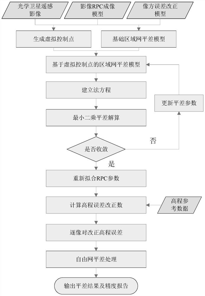
[0061] The specific implementation of the present invention will be described in detail below in conjunction with the accompanying drawings and examples. This method adopts the processing method of block adjustment-height error post-test compensation-re-block adjustment to process the block adjustment of optical satellite remote sensing images, and eliminates the elevation error and elevation error in the block network under the condition of lack of ground control constraints. The cumulative effect of the image positioning error caused by the error ensures the accuracy and reliability of the block adjustment. see figure 1 , the implementation process of the present invention can be divided into following 5 steps:

[0062] Step 1. By dividing the uniform grid on the image in the regional network, virtual control points are generated, and the basic adjustment model is established by introducing an additional error compensation model into the image square of the initial RPC mode...


PUM


Abstract

The invention provides an optical satellite remote sensing image block adjustment method and system based on post-check compensation, which combines robust block adjustment and error post-check compensation, and compensates systematic elevation errors in a block at a low cost after block adjustment; block adjustment is adopted to realize consistency processing of geometric accuracy of images in the block so that problems of elevation errors in the block and error accumulation caused by the elevation errors under the condition of lack or no ground control point are solved.

Description

technical field [0001] The invention belongs to the field of optical satellite remote sensing image processing, and relates to an optical satellite remote sensing image area network adjustment method and system based on posterior compensation. Background technique [0002] Block adjustment is an important part of geometric preprocessing of optical satellites and an effective means to improve the geometric quality of images. The demand for high-precision mapping for global regions is becoming more and more urgent, but most areas of the global land surface cannot obtain high-precision ground control points, and it is necessary to use the block adjustment method that lacks ground control point constraints. In the absence of ground control points, not only the block network itself lacks absolute constraints, but also affects the convergence and accuracy of the adjustment calculation. Due to the initial geometric positioning error of the image, the block adjustment cannot converg...

Claims


Application Information

Patent Timeline
IPC IPC(8): G01C25/00G06T7/73
CPCG01C25/00G06T7/73G06T2207/10032
Inventor 皮英冬李欣杨博王密王太平
Owner WUHAN UNIV
Features
  • R&D
  • Intellectual Property
  • Life Sciences
  • Materials
  • Tech Scout
  • Unparalleled Data Quality
  • Higher Quality Content
  • 60% Fewer Hallucinations
Learn More