Automatic parameterization three-dimensional pipeline modeling method and system based on GIS (Geographic Information System)
A technology of three-dimensional pipeline and modeling method, applied in 3D modeling, image data processing, design optimization/simulation, etc.
- Summary
- Abstract
- Description
- Claims
- Application Information
AI Technical Summary
Problems solved by technology
Method used
Image
Examples
Embodiment 1
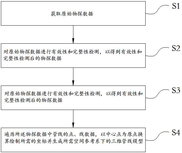
[0061] refer to figure 1 As shown, the present invention provides a kind of automatic parametric three-dimensional pipeline modeling method based on GIS system, comprising the following steps:
[0062] S1: Obtain the original geophysical data.
[0063] In this embodiment, the original geophysical prospecting data includes point data and line data of corresponding pipelines which are stored according to pipeline types. It should be noted that the original geophysical data may be the raw geophysical data of pipelines read from databases including but not limited to SHP or MDB format.
[0064] In the embodiment of the present invention, the surface data of the corresponding pipeline can also be read.
[0065] S2: Carry out validity and completeness testing on the original geophysical prospecting data to obtain the geophysical prospecting data after validity and completeness testing.
[0066] It should be noted that, in the specific implementation of step S2 provided in the emb...
Embodiment 2
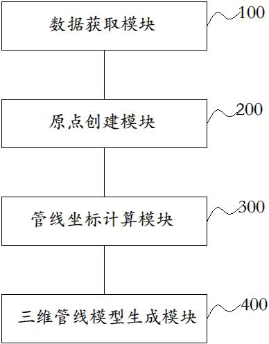
[0116] image 3 Shown is a structural block diagram of the GIS system-based automatic parameterized three-dimensional pipeline modeling system provided in Embodiment 2 of the present invention. The GIS system-based automatic parameterized three-dimensional pipeline modeling system includes: a data acquisition module 100, an origin creation module 200 . A pipeline coordinate calculation module 300 and a three-dimensional pipeline model generation module 400 . in:
[0117] The data acquisition module 100 is configured to acquire raw geophysical data including point data and line data of corresponding pipelines stored according to pipeline types, and check the validity and integrity of the data.
[0118] In this embodiment, the original geophysical prospecting data includes point data and line data of corresponding pipelines that are stored according to pipeline types. It should be noted that the original geophysical data may be the raw geophysical data of pipelines read from d...
PUM
 Abstract
Description
Claims
Application Information
 - R&D
- Intellectual Property
- Life Sciences
- Materials
- Tech Scout
- Unparalleled Data Quality
- Higher Quality Content
- 60% Fewer Hallucinations
Browse by: Latest US Patents, China's latest patents, Technical Efficacy Thesaurus, Application Domain, Technology Topic, Popular Technical Reports.
© 2025 PatSnap. All rights reserved.Legal|Privacy policy|Modern Slavery Act Transparency Statement|Sitemap|About US| Contact US: help@patsnap.com


