Modeling method and system of automatic parametric 3D pipeline based on gis system

A 3D pipeline, parametric technology, used in 3D modeling, image data processing, design optimization/simulation, etc.

Active Publication Date: 2022-05-13
武汉智联时空科技有限公司
View PDF10 Cites 0 Cited by
  • Summary
  • Abstract
  • Description
  • Claims
  • Application Information

AI Technical Summary

Problems solved by technology

[0007] In order to solve many problems faced by manual modeling, the purpose of the embodiment of the present invention is to provide a method that can automatically check the correctness and completeness of the original geophysical data, and automatically and efficiently generate WGS84 (WorldGeodetic System 1984, for A system and method for a parameterized three-dimensional pipeline model in an easy-to-publish standard format of the coordinate system established by the GPS global positioning system) coordinates, and the data published on the web side can be generated through the built model

Method used


Image

  • Modeling method and system of automatic parametric 3D pipeline based on gis system
  • Modeling method and system of automatic parametric 3D pipeline based on gis system
  • Modeling method and system of automatic parametric 3D pipeline based on gis system

Examples


Embodiment 1

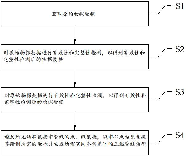
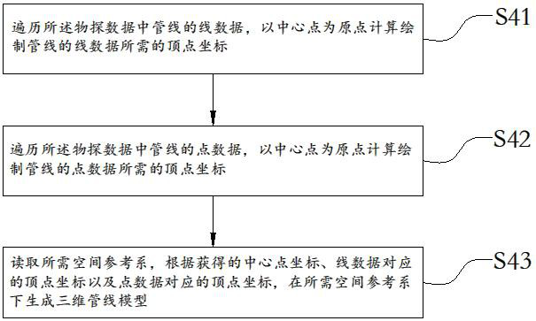
[0061] refer to figure 1 As shown, the present invention provides a kind of automatic parametric three-dimensional pipeline modeling method based on GIS system, comprising the following steps:

[0062] S1: Obtain the original geophysical data.

[0063] In this embodiment, the original geophysical prospecting data includes point data and line data of corresponding pipelines which are stored according to pipeline types. It should be noted that the original geophysical data may be the raw geophysical data of pipelines read from databases including but not limited to SHP or MDB format.

[0064] In the embodiment of the present invention, the surface data of the corresponding pipeline can also be read.

[0065] S2: Carry out validity and completeness testing on the original geophysical prospecting data to obtain the geophysical prospecting data after validity and completeness testing.

[0066] It should be noted that, in the specific implementation of step S2 provided in the emb...

Embodiment 2

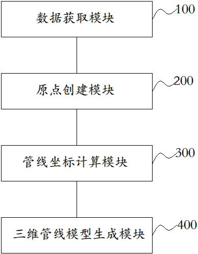
[0116] image 3 Shown is a structural block diagram of the GIS system-based automatic parameterized three-dimensional pipeline modeling system provided in Embodiment 2 of the present invention. The GIS system-based automatic parameterized three-dimensional pipeline modeling system includes: a data acquisition module 100, an origin creation module 200 . A pipeline coordinate calculation module 300 and a three-dimensional pipeline model generation module 400 . in:

[0117] The data acquisition module 100 is configured to acquire raw geophysical data including point data and line data of corresponding pipelines stored according to pipeline types, and check the validity and integrity of the data.

[0118] In this embodiment, the original geophysical prospecting data includes point data and line data of corresponding pipelines that are stored according to pipeline types. It should be noted that the original geophysical data may be the raw geophysical data of pipelines read from d...


PUM


Abstract

The invention relates to the technical field of automatic three-dimensional modeling, in particular to an automatic parameterized three-dimensional pipeline modeling method and system based on a GIS system. The method includes: obtaining original geophysical prospecting data, the original geophysical prospecting data including point data and line data of corresponding pipelines respectively stored according to pipeline types; performing validity and completeness detection on the original geophysical prospecting data to obtain validity and completeness detection Geophysical prospecting data; traverse all geophysical prospecting data to obtain the center point, and create the center point as the origin of the local coordinate system of the model; traverse the point data and line data of the pipeline in the geophysical prospecting data, use the center point as the origin to convert and draw the required coordinates and generate the A 3D pipeline model in a spatial reference system is required. The invention automatically generates a three-dimensional pipeline model in a required space reference system with minimal manual operations, realizes automatic connection between pipelines and pipe points, appendages, and feature points, fits the ground, and forms nearly real three-dimensional visualization model data of underground pipelines.

Description

technical field [0001] The invention relates to the technical field of automatic three-dimensional modeling, in particular to an automatic parameterized three-dimensional pipeline modeling method and system based on a building information model (BIM) and a geographic information system (GIS) system. Background technique [0002] In the geographic information system (GIS) project of three-dimensional comprehensive pipeline or professional pipeline, it involves the modeling of various types of pipelines such as electric power, telecommunications, water supply, drainage, heat, gas, etc., and the structures, There are many sizes, and different types of pipelines have slightly different definitions of some attributes such as caliber and buried depth, and the coordinates of their geophysical source data mostly use CGCS2000 (China Geodetic Coordinate System 2000) coordinates, and some geophysical units use offset local coordinates Tie. Using manual modeling will face many problems...

Claims


Application Information

Patent Timeline
Patent Type & Authority Patents(China)
IPC IPC(8): G06T17/00G06F30/18G06F30/20G06F113/14
CPCG06T17/00G06F30/18G06F30/20G06F2113/14
Inventor 闫跃郛张创王道胜赵志友鲁苗
Owner 武汉智联时空科技有限公司
Why Eureka
Try Eureka