Long time-series identification method of coastal zone regional functions based on multi-source big data

An identification method and technology for coastal zones, applied in character and pattern recognition, instruments, calculations, etc., can solve the problem of weak research on coastal zone functional identification and change monitoring, lack of attention to functional changes, and constraints on identification and change detection accuracy, etc. question

Active Publication Date: 2022-06-14
INST OF GEOGRAPHICAL SCI & NATURAL RESOURCE RES CAS
View PDF8 Cites 0 Cited by
  • Summary
  • Abstract
  • Description
  • Claims
  • Application Information

AI Technical Summary

Problems solved by technology

The outstanding performances are as follows: First, the functional classification system of the coastal zone still focuses on the land cover / land use system, lacking the overall consideration of land and sea, especially the lack of attention to the main functional changes that affect the sustainable development of the coastal zone; When solving the classification mapping and change detection of complex areas such as coastal zones, it is necessary to further leverage the advantages of multi-source data fusion of the big data platform; the third is long-term, large-scale, high-density coastal zone regional function identification and change monitoring. The research is relatively weak. Few of these existing studies can take into account the reasonable change logic between the time series and spatial neighborhoods of the unique geographical function types of the coastal zone, which seriously restricts the accuracy of its identification and change detection.

Method used


Image

  • Long time-series identification method of coastal zone regional functions based on multi-source big data
  • Long time-series identification method of coastal zone regional functions based on multi-source big data
  • Long time-series identification method of coastal zone regional functions based on multi-source big data

Examples


Embodiment Construction

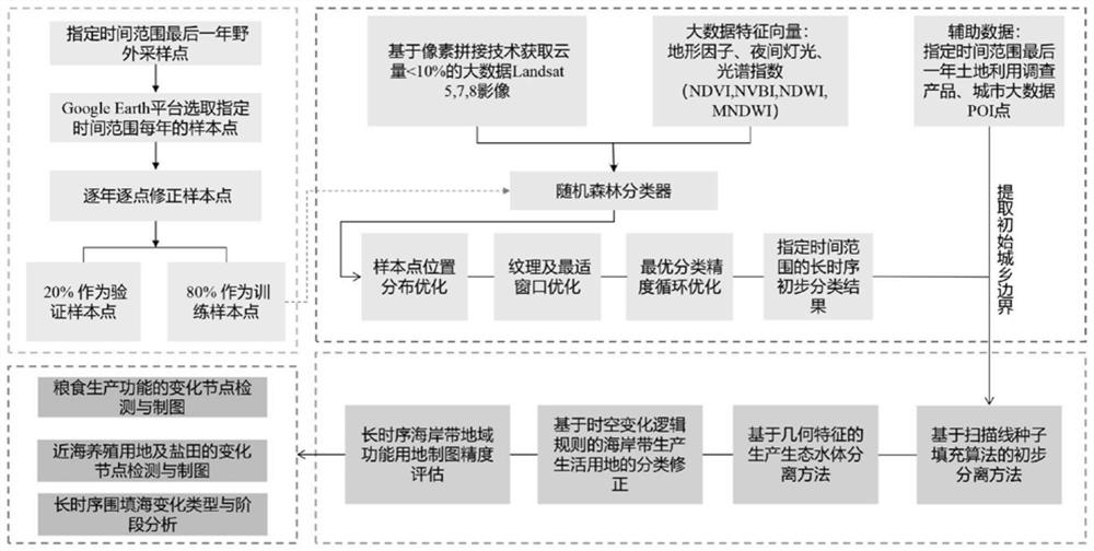
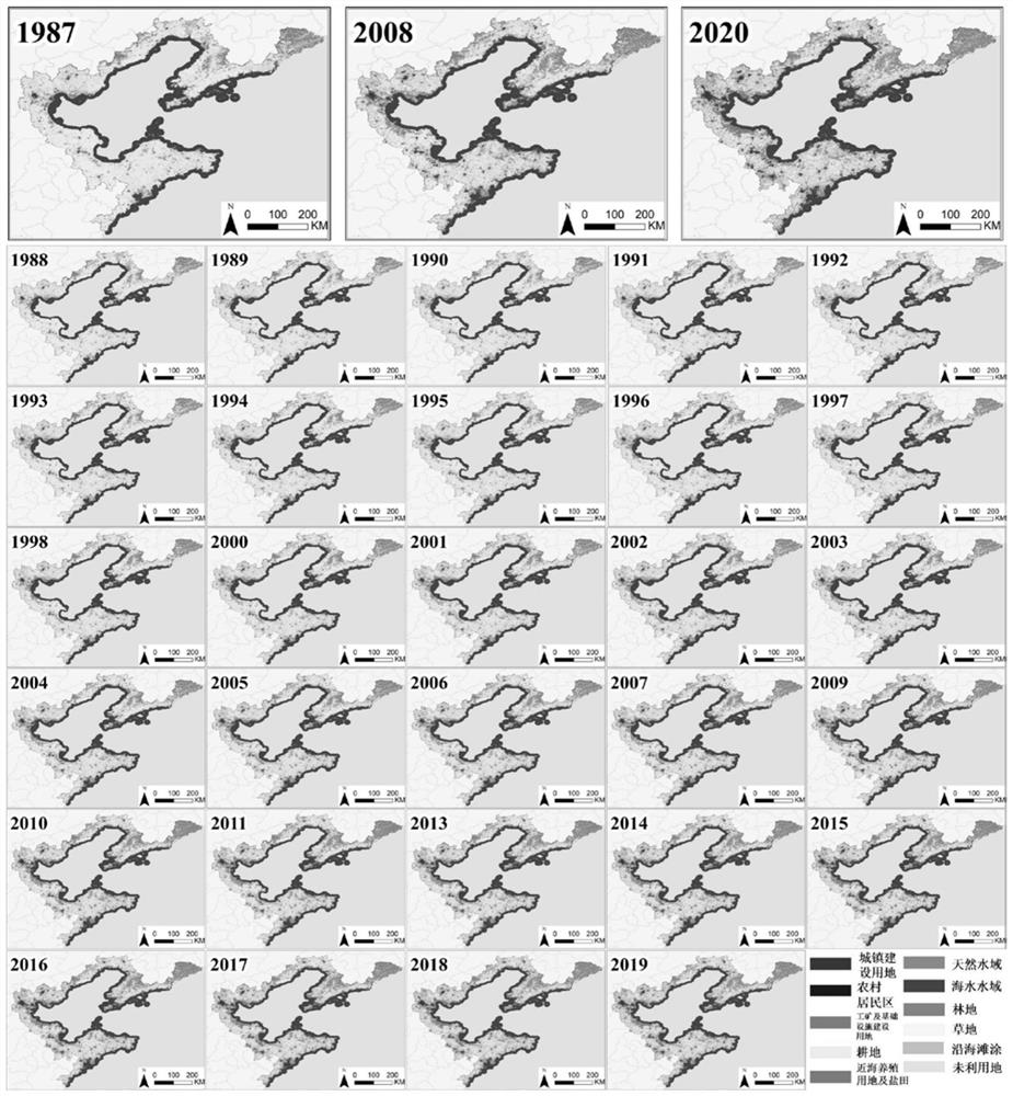
[0049] The experimental data used in this experiment include: Landsat series images for 32 years from 1987 to 2020, surface reflectance products, 30m resolution; VIIRS nighttime light data (Nighttime Day / Night Band CompositesVersion 1), 500m resolution; 2020 digital elevation Data (SRTM), 30m resolution; 2020 urban point of interest (POI) data; 2020 annual administrative division data of townships and administrative villages. like figure 1 shown.

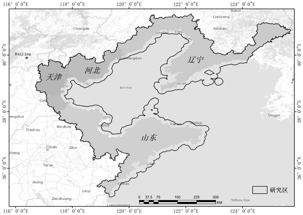
[0050]The Bohai Rim coastal zone is selected as the study area in the northeastern part of my country, starting from Panshan County, Liaoning Province in the north, and extending to Rizhao City, Shandong Province in the south (35°5′-41°27′N, 116°42′-125°41′E). The total length is about 6,050 kilometers, accounting for one-third of the total length of the country's coastline. The coastal zone around the Bohai Sea involves Shandong, Hebei, Liaoning and Tianjin, with a total of 17 coastal cities. The coastal zone around the Bohai Se...


PUM


Abstract

The present invention relates to a long time-series identification method for coastal zone functions based on multi-source big data. The forest algorithm performs initial classification on long time series images. Secondly, the spatial separation of impermeable surface and water body is achieved by using the scanning line seed filling algorithm and geometric feature analysis, and the functional types involved in the transformation of cultivated land, offshore aquaculture land, salt pans, and sea reclamation are corrected based on the logic rules of time and space changes. Finally, based on the classification results, the range and time period of changes in grain production, offshore aquaculture, and reclamation were extracted. This method improves the accuracy of long-term recognition of coastal regional functions, and is especially suitable for long-term, large-scale, high-density near-coastal human activities. Auxiliary decision-making for spatial planning and regional policy.

Description

technical field [0001] The invention relates to a long-sequence identification method of long-sequence coastal zone regional functions based on multi-source big data, in particular to a long-sequence identification of the transformation of regional functional land and reclamation construction caused by coastal human activities based on remote sensing big data classification method. Background technique [0002] The coastal zone is an area with high population and economic agglomeration and rapid growth, and it is also the area where the relationship between man and land is the most intense. Driven by the growing human demand for seafood and the economic benefits of coastal economic development, whether it is the land part of the coastal zone or the offshore waters, in addition to traditional seawater / mixed aquaculture, salt pans and other human production activities, reclamation is used for port industry. Park development, coastal real estate development, coastal tourism an...

Claims


Application Information

Patent Timeline
Patent Type & Authority Patents(China)
IPC IPC(8): G06V20/17G06V10/764G06K9/62
CPCG06F18/24323
Inventor 王亚飞
Owner INST OF GEOGRAPHICAL SCI & NATURAL RESOURCE RES CAS
Why Eureka
Try Eureka